 NAMBUCCA
SHIRE COUNCIL
Ordinary Council Meeting
AGENDA ITEMS
12 June 2014
Council
has adopted the following Vision and Mission Statements to describe its
philosophy and to provide a focus for the principal activities detailed in its
Management Plan.
Our Vision
Nambucca Valley ~ Living at its best.
Our Mission Statement
‘The Nambucca Valley will value and protect its natural
environment, maintain its assets and infrastructure and develop opportunities
for its people.’
Our Values
in Delivery
·
Effective leadership
·
Strategic direction
·
Sustainability of infrastructure and
assets
·
Community involvement and enhancement
through partnerships with Council
·
Enhancement and protection of the
environment
·
Maximising business and employment
opportunities through promotion of economic development
·
Addressing social and cultural needs of
the community through partnerships and provision of facilities and services
·
Actively pursuing resource sharing
opportunities
Council
Meetings: Overview and Proceedings
Council meetings are held on the last
Thursday of each month AND on the Thursday two weeks before the Thursday
meeting. Both meetings commence at 5.30 pm. Meetings are held in the
Council Chamber at Council's Administration Centre—44 Princess Street,
Macksville (unless otherwise advertised).
How
can a Member of the Public Speak at a Council Meeting?
1 Addressing
Council with regard to an item on the meeting agenda:
Members
of the public are welcome to attend meetings and address the Council.
Registration to speak may be made by telephone or in person before 2.00 pm on a
meeting day. The relevant agenda item will be brought forward at 5.30 pm in
agenda order, and dealt with following preliminary business items on the
agenda. Public addresses are limited to five (5) minutes per person with a
limit of two people speaking for and two speaking against an item.
2 Public
forum address regarding matters not on the meeting agenda:
Council
allows not more than two (2) members of the public per meeting to address it on
matters not listed in the agenda provided the request is received before
publication of the agenda and the subject of the address is disclosed and
recorded on the agenda.
Speakers
should address issues and refrain from making personal attacks or derogatory remarks.
You must treat others with respect at all times.
Meeting
Agenda
These
are available Council’s website: www.nambucca.nsw.gov.au
NAMBUCCA SHIRE COUNCIL
Ordinary Council Meeting - 12 June 2014
Acknowledgement of Country
(Mayor)
I would like to acknowledge the Gumbaynggirr people who
are the Traditional Custodians of this Land. I would also like to pay
respect to the elders both past and present and extend that respect to any
Aboriginal People present.
AMENDED AGENDA Page
1 APOLOGIES
2 PRAYER
3 DISCLOSURE OF INTEREST
4 CONFIRMATION OF MINUTES —
Ordinary Council Meeting - 29 May 2014...................................................................................... 5
5 NOTICES OF MOTION
5.1 Notice of Motion - Request For Suggestions to Offset Loss of
Financial Assistant Grants Funding (SF851).......................................................................................................................... 12
5.2 Notice Of Motion - Change To XPT Train Timetable (SF92)................................................ 14
5.3 Notice Of Motion - Future Of Macksville Hospital (SF988) - DELEGATION........................ 21
6 PUBLIC FORUM/DELEGATIONS
5.3 Notice Of Motion - Future Of Macksville Hospital ............................................................ 21
i) Dr Daniel Ryan – Supporting Notice of Motion
9.3 Proposed Link Road Extension of Marshall
Way - Nambucca Gardens Estate................... 36
i) Mr
Mal Boden – Objector
ii) Mr
Kevin Ballangarry - Objector
iii) Mr
Geoff Smythe (Consulting) – on behalf of applicant
7 ASKING OF QUESTIONS
WITH NOTICE
8 QUESTIONS
FOR CLOSED MEETING WHERE DUE NOTICE HAS BEEN RECEIVED
9 General Manager Report
9.1 Outstanding Actions and Reports.................................................................................... 23
9.2 Consultation on the Crown Lands Legislation White Paper................................................ 30
9.3 Proposed Link Road Extension of Marshall Way - Nambucca Gardens
Estate................... 36
9.4 Donation to St Patrick's Primary School Biennial Fete...................................................... 62
9.5 IPART - Draft Report on Local Government Compliance and
Enforcement......................... 65
9.6 Annual Reporting of Contracts for Senior Staff................................................................ 81
9.7 Pelican Park - Review of On Site Sewerage Management System .................................... 84
9.8 Outstanding DA's greater than 12 months, applications where
submissions received not determined from 21-31 May 2014.................................................................................................... 148
9.9 Council Ranger's Report May 2014................................................................................ 152
9.10 Independent Pricing and Regulatory Tribunal (IPART) - Draft Report
on Reforming Licensing in NSW.................................................................................................................................... 156
9.11 Report to JRPP - Bellwood subdivision - DA 2012/011................................................... 164
9.12 Construction and Complying Development Certificates Approved May
2014.................... 210
9.13 2014 May - Development and Complying Development Applications
Received................ 215
10 Assistant General Manager
Corporate Services Report
10.1 Investment Report To 31 May 2014................................................................................ 217
10.2 Schedule of Council Public Meetings............................................................................. 222
11 Assistant General Manager
Engineering Services Report
11.1 Request for Council to upgrade the end of Maras Creek Road to
accommodate bus and truck movement.................................................................................................................... 223
11.2 Naming the Old Pacific Highway.................................................................................... 225
12 GENERAL MANAGER’S
SUMMARY OF ITEMS TO BE DISCUSSED IN CLOSED MEETING
12.1 Submissions – DA2013/183 –
Proposed Link road Extension of Marshall Way – Nambucca Gardens Estate
It is recommended that
the Council resolve into closed session with the press and public excluded to
allow consideration of this item, as provided for under Section 10A(2)(e) of
the Local Government Act, 1993, on the grounds that the report contains
information that would, if disclosed, prejudice the maintenance of law.
12.2 Submission
– DA2012/011 – Proposed 346 Lot Residential Subdivision – Alexandra Drive,
Bellwood
It is recommended that
the Council resolve into closed session with the press and public excluded to
allow consideration of this item, as provided for under Section 10A(2)(e) of
the Local Government Act, 1993, on the gorunds that the report contains
information that would, if disclosed, prejudice the maintenance of law.
12.3 Bowraville Off River Water
Storage – Claim for Foundation Preparation.
It is recommended that
the Council resolve into closed session with the press and public excluded to
allow consideration of this item, as provided for under Section 10A(2)(c) of
the Local Government Act, 1993, on the grounds that the report contains
information that would, if disclosed, confer a commercial advantage on a person
with whom the Council is conducting (or proposes to conduct) business.
A Questions raised by Council in 8 above
i) MOTION TO CLOSE THE MEETING
ii) PUBLIC VERBAL REPRESENTATIONS
REGARDING PROPOSAL TO CLOSE
iii) CONSIDERATION OF PUBLIC
REPRESNETATIONS
iv) DEAL LWITH MOTION TO CLOSE THE
MEETING
13 MEETING CLOSED TO THE PUBLIC
14 REVERT TO OPEN MEETING FOR DECISIONS IN
RELATION TO ITEMS DISCUSSED IN CLOSED MEETING
NAMBUCCA SHIRE COUNCIL

DISCLOSURE OF INTEREST AT MEETINGS
|
Name of Meeting:
|
|
|
Meeting Date:
|
|
|
Item/Report Number:
|
|
|
Item/Report Title:
|
|
|
|
|
|
I
|
|
declare the following interest:
|
|
(name)
|
|
|
|
|
|
|
Pecuniary – must leave chamber, take no part in discussion
and voting.
|
|
|
|
|
|
|
|
|
Non Pecuniary – Significant Conflict – Recommended that Councillor/Member
leaves chamber, takes no part in discussion or voting.
|
|
|
Non-Pecuniary – Less Significant Conflict – Councillor/Member may choose to remain
in Chamber and participate in discussion and voting.
|
|
For the reason that
|
|
|
|
|
|
|
|
|
|
|
|
Signed
|
|
Date
|
|
|
|
|
|
|
Council’s Email Address – council@nambucca.nsw.gov.au
Council’s Facsimile Number – (02) 6568 2201
(Instructions
and definitions are provided on the next page).
Definitions
(Local Government Act and Code of Conduct)
Pecuniary – An interest that a person has in a matter because of a reasonable
likelihood or expectation of appreciable financial gain or loss to the person
or another person with whom the person is associated.
(Local Government Act, 1993 section 442 and 443)
A Councillor or other member of a Council Committee
who is present at a meeting and has a pecuniary interest in any matter which is
being considered must disclose the nature of that interest to the meeting as
soon as practicable.
The Council or other member must not take part in the
consideration or discussion on the matter and must not vote on any question
relating to that matter. (Section 451).
Non-pecuniary – A private or personal interest the council official
has that does not amount to a pecuniary interest as defined in the Act (for
example; a friendship, membership of an association, society or trade union or
involvement or interest in an activity and may include an interest of a
financial nature).
If you have declared a non-pecuniary conflict of
interest you have a broad range of options for managing the conflict. The
option you choose will depend on an assessment of the circumstances of the
matter, the nature of your interest and the significance of the issue being
dealt with. You must deal with a non-pecuniary conflict of interest in at
least one of these ways.
·
It may be appropriate
that no action is taken where the potential for conflict is minimal. However, council officials should consider providing an explanation of why they consider a conflict
does not exist.
·
Limit involvement if
practical (for example, participate in discussion but not in decision making or
visa-versa). Care needs to be taken when exercising this option.
·
Remove the source of
the conflict (for example, relinquishing or divesting the personal interest
that creates the conflict or reallocating the conflicting duties to another
officer).
·
Have no involvement by
absenting yourself from and not taking part in any debate or voting on the
issue as if the provisions in section 451(2) of the Act apply (particularly if
you have a significant non-pecuniary conflict of interest).
Ordinary
Council Meeting
MINUTES
OF THE Ordinary Council
Meeting HELD ON 29 May
2014
The following document is the
minutes of the Ordinary Council meeting held on 29 May 2014. These
minutes are subject to confirmation as to their accuracy at the next meeting to
be held on 12 June 2014 and therefore subject to change. Please refer to
the minutes of 12 June 2014 for confirmation.
PRESENT
|
Cr Rhonda Hoban (Mayor)
|
Cr John Ainsworth
|
|
Cr Martin Ballangarry OAM
|
Cr Brian Finlayson
|
|
Cr Kim MacDonald
|
|
ALSO PRESENT
|
Michael Coulter (General Manager)
|
Scott Norman (AGM Corporate Services)
|
|
Paul Gallagher (AGM Engineering Services)
|
Monika Schuhmacher (Minute Secretary)
|
The Mayor welcomed a group of
young, local Venturers from the Scouting movement who were attending Council
meeting as part of their training.
APOLOGIES
Cr Bob Morrison, Cr Anne Smyth, Cr Paula Flack and Cr Elaine
South
PRAYER
Pastor Darryl Spriggs from the Presbyterian Church offered a
prayer on behalf of the Nambucca Minister's Association.
DISCLOSURE OF INTEREST
There were no disclosures of interest.
|
CONFIRMATION OF MINUTES - Special Meeting of
Council 22 May 2014
|
|
267/14 RESOLVED: (MacDonald/Ainsworth)
That the minutes of the Special Meeting of Council of
22 May 2014 be confirmed.
|
|
CONFIRMATION OF MINUTES – LAND DEVELOPMENT
COMMITTEE Meeting 22 May 2014
|
|
268/14 RESOLVED: (Ainsworth/Finlayson)
That the minutes of the Land Development Committee
Meeting of 22 May 2014 be confirmed.
|
NOTICE OF MOTION - CR Hoban
– LATE
|
ITEM 5.1 SF851 290514 Australian
Local Government Association (ALGA) - Call to have the Australian Government
Restore the Indexation of the local government Financial Assistance Grants
(FAGs)
|
|
269/14 RESOLVED: (Hoban/MacDonald)
That Council
make representations to the Member for Cowper, the Hon. Luke Hartsuyker MP as
well as the Australian Labor Party and the Australian Greens calling for the
Government to restore the indexation of the local government Financial
Assistance Grants.
|
NOTICE OF MOTION - CR Smyth
– LATE
|
ITEM 5.2 SF1933 290514 Notice
of Motion - Request for Leave - Cr Anne Smyth - 26 April to 30 June 2014
(SF1228)
|
|
270/14 RESOLVED: (Hoban/Ainsworth)
That Cr Anne Smyth be
granted leave of absence in accordance with Section 234(d) of the Local
Government Act for the period 26 April to 30 June 2014 inclusive.
|
|
PUBLIC FORUMS
|
|
RESOLVED (Ainsworth/MacDonald)
That the following speaker be heard:
i) Ms Moira Ryan - Community Strategic Plan
(Public Forum)
ii) Mr Michael Blockey - Community Strategic
Plan (Public Forum)
iii) Mr Paul Foley - Pedestrian danger on Adin Street
joining oval and provision of a walkway
iv) Mr
Mark Brazel - Caravan Park - entry point - increase in payment - reduction
in lease term – Mr Brazel did not attend the meeting
|
Ms Moira Ryan addressed Council making the following points:
·
Flurry of activity by Council in Scotts Head this week
·
Ms Ryan is the Secretary of community group and will comment on Community Strategic Plan
·
No 355 committees in Scotts Head so cannot see how Scotts Head
residents can contribute
·
Scotts Head Road pretty dreadful and is major topic of interest
·
One cut slash of vegetation on edge of road is of great concern
·
Slasher needs to be washed down regularly as weeds get spread
·
Requested down grade of speed limit – would like 80 km/hr speed
all along Scotts Head Road
·
Major intersection camber is an issue
·
Town entry – pretty horrible – cattle yards
·
What happens to Section 94 money for Scotts Head?
·
Footpaths required, more connectivity between shops and club –
many elderly residents
·
Commitment from Council that money from lease would be used on
Scotts Head
·
West Street is a major access and requires a proper footpath
·
The Reserve not being maintained
·
Needs a town central meeting place other than the Surf Club, not
that accessible, or free, nowhere in town where practitioners come to meet with
residents, no visiting/meeting rooms
·
Perhaps something could be done in collaboration with Council and
Surf Club
·
Street sweeping only done annually, needs to be done regularly,
polluting stormwater drains and creek
·
Beach – used to be raked occasionally – nothing with maintenance
of beach now…heap of rubbish, prime tourist area
·
No maintenance of shower in West Street
·
Animals on beach is a huge problem particularly off-leash dogs,
signs too small in main parking area
·
Residents pick up rubbish on the beach
·
Strategic Plan needs some vamping up
·
Safety, Policing – support Council’s initiative in seeking 24
hour Police presence
·
Late night hooning – cars, fires on beach, burning vegetation,
Inspector/Ranger would be good if came out at night
·
Item 11.3 in report – is totally illogical
Mr Michael Blockey addressed
Council making the following points:
·
Chairman of the Community Group
·
Master Plan – would like further consultation from Council
·
Subdivision of Council land – community not told much about it,
rumours abound
·
Council could have been putting information in the local
newsletter
·
Asked if General Manager could provide information
·
Walking track/bush tucker – want a dream time walk around Scotts
Head – could Council assist with this? Walking track from Headland, behind
Little Beach, Elephant Head, school
|
271/14 Resolved: (MacDonald/Ainsworth)
That Mr Jason O’Donnell, President of the
Macksville-Scotts Head Surf Life Saving Club be granted permission to address
Council.
|
Mr Jason O’Donnell addressed
Council making the following points:
·
Mr O’Donnell advised that the Surf Club has received dollar for
dollar funding to put in a toilet for the people with a disability.
Mr Paul Foley addressed Council making the following points:
·
Wants walkway built along Adin Street
·
New footpath is on cliff and would be too costly
·
Children do not understand the concept of no-footpath
·
No dogs on leash allowed through caravan park
·
No dogs on beach during day
·
Therefore most people take the drive option to the shops
·
Discussed obesity in relation to drive to the shop option – no
safe walkway
·
South side of road is too steep for footpath, road is very
narrow,
·
Reducing speed limit is not necessarily the answer – speeding
cars are not the problem the walk ways are the problem
·
Walkway on edge of oval
·
Perhaps take strip of oval back at base of cliff to build a
walkway
·
How will this be paid for? From the holiday park people? Need
Council to be strong, make a better deal to extract from these people who are
getting the prime real estate to better Scotts Head
·
Council needs to act against State Government that is in the
hands of developers
·
Wants Council to make a deal for the Scotts Heads residents
·
Can’t afford any further increases in rates
·
Section 94 funds?
·
Would not want concrete path….gravel/dirt would be more
attractive
ASKING OF
QUESTIONS WITH NOTICE
There were no Questions with Notice.
QUESTIONS FOR CLOSED MEETING
WHERE DUE NOTICE HAS BEEN RECEIVED
There were no Questions for Closed Meeting where due Notice
has been received.
General Manager
Report
|
ITEM 9.1 SF959 290514 Outstanding
Actions and Reports
|
|
272/14 RESOLVED: (Ballangarry/Ainsworth)
That
the list of outstanding actions and reports be noted and received for
information by Council.
|
|
ITEM 9.2 SF1948 290514 Proposed
Highway Service Centre - Nambucca Heads Interchange
|
|
273/14 RESOLVED: (Ainsworth/MacDonald)
1 That Council make a written submission to Roads and
Maritime Services in support of the revised policy for the location of
highway service centres, and particularly the proposed highway service centre
at the Nambucca Heads interchange.
2 That Council note the RMS is calling for expressions of
interest to develop a highway service centre at the Nambucca Heads
interchange.
|
|
ITEM 9.3 SF254 290514 Proposed
Local Government Boundary Adjustment between Nambucca and Bellingen Shire
Councils
|
|
274/14 RESOLVED: (MacDonald/Ballangarry)
1 That Nambucca Shire Council support a submission to the
NSW Minister for Local Government for a boundary adjustment transferring part
Lots 11 and 12 DP 851841 to Nambucca Shire Council.
2 That Bellingen Shire Council be thanked for initiating
the local government boundary adjustment; for dealing with the affected
property owners and for preparing a report on the matter.
|
|
ITEM 9.4 SF1415 290514 Internal
Audit - Engagement of Service Provider
|
|
275/14 RESOLVED: (Ainsworth/MacDonald)
Subject to
clarification on responsibility for employment costs, Nambucca Shire Council
engage Coffs Harbour City Council to provide internal audit services for an
initial two (2) year term.
|
|
ITEM 9.5 SF988 290514 Provision
of a Renal Dialysis Service in the Nambucca Valley
|
|
276/14 RESOLVED: (Ainsworth/MacDonald)
That
Council extend its thanks to the Mid North Coast Local Health District Board
and its Chief Executive for awarding a contract to the Nambucca Health Care
Centre to partner with the Health District in providing dialysis services in
the Nambucca Valley.
|
|
ITEM 9.6 DA2014/056 290514 3
Lot Subdivision - Adin Street, Scotts Head
|
|
277/14 RESOLVED: (Ainsworth/Finlayson)
That Council as the consent authority, pursuant Section
80 of the Environmental Planning and Assessment Act 1979, grant consent
for Development Application 2014/056 for a three lot subdivision of Lot 104
DP 622709, subject to the schedule of conditions outlined in attachment 3
of this report.
For the motion – Councillors Hoban, Ballangarry,
Finlayson, Ainsworth and MacDonald (Total 5)
Against the motion - nil
|
|
ITEM 9.7 SF1947 290514 Outstanding
DA's greater than 12 months, applications where submissions received not
determined from 8 - 20 May 2014
|
|
278/14 RESOLVED: (MacDonald/Ainsworth)
That the applications where
submissions have been received be noted and received for information by
Council.
|
|
ITEM 9.8 SF1804 290514 Vegetation
Mapping and Koala Habitat Study
|
|
279/14 RESOLVED: (MacDonald/Ballangarry)
1 That Council accept the funding
offer of $70,000 from the Office of Environment and Heritage to commence CLASS
5 vegetation mapping of the areas (gaps) not included in the previous mapping
of Endangered Ecological Communities.
2 That Council accept the funding offer of $50,000 from the
Office of Environment and Heritage under the state government’s Saving
Our Species koala ‘iconics’ funding in the next financial year for koala
habitat study, mapping and reporting.
3 That $10,000 and be committed from Councils Environmental
Levy to contribute to the project and staff resources be allocated as
necessary to assist OEH in the management of project.
|
General Manager
Report – LATE
|
ITEM 9.9 SF688 290514 Environmental
Levy Program
|
|
280/14 RESOLVED: (Ainsworth/Ballangarry)
1 That following completion of the exhibition of the draft
operational plan/delivery program that Council consider the 2014/15
Environmental Levy Budget comprising the projects shown in the table
headed “Proposed 2014/15 Environmental Levy Budget”.
2 That Council accept the offer of up to
$7,500 Heritage Advisor Funding for the 2014/15 Heritage Program, requiring
matching funds from Council.
|
Assistant General
Manager Corporate Services Report
|
ITEM 10.1 SF1871 290514 March
2014 Budget Review
|
|
281/14 RESOLVED: (MacDonald/Ainsworth)
1 That the budget
review for the quarter ended 31 March, 2014 be received.
2 That the recommended increases and decreases in votes be
included as subsequent votes for the financial year 2013/2014.
|
|
ITEM 10.2 SF316 290514 Macksville
Gift Committee of Management - AGM - 31 March 2014 - Minutes
|
|
282/14 RESOLVED: (Ainsworth/Ballangarry)
That
Council endorse the minutes of the Committee of Management for the Macksville
Gift, held on 31 March 2014.
|
|
ITEM 10.3 SF251 290514 Schedule
of Council Public Meetings
|
|
283/14 RESOLVED: (Ainsworth/MacDonald)
That the schedule of dates
for public Council meetings be noted and received for information by Council.
|
Assistant General
Manager Engineering Services Report
|
ITEM 11.1 SF844 290514 Nambucca
District Water Supply Steering Committee Meeting - 7 May 2014
|
|
284/14 RESOLVED: (Ainsworth/Ballangarry)
That the minutes of the
record of discussion held on 7 May 2014 in lieu of the formal Steering
Committee Meeting be received and noted by Council.
|
|
ITEM 11.2 SF711 290514 Tender
for Supply and Delivery of Bulk Chemicals for Water Treatment
|
|
285/14 RESOLVED: (Ainsworth/MacDonald)
1 That Council award contracts for the supply and delivery of
bulk chemicals in accordance with the recommendations of the Tender
Evaluation Committee for Tender T051415 called by Regional Procurement as
follows:
Omega Chemicals - Aluminium Sulphate –
Redox Pty Ltd - Hydrated Lime and Sodium Fluoride (Granular)
Price Chemicals – Sodium Hypochlorite
2 That Council award the contracts for a period of 2 years
commencing 1 July 2014 with the provision of a further 1 year period subject
to satisfactory performance.
|
|
ITEM 11.3 SF853 290514 Salvinia
Molesta Infestation - Swimming Creek, Nambucca Heads
|
|
286/14 RESOLVED: (Ainsworth/Finlayson)
That
Council approve the use of registered herbicides on the Salvinia Molesta
infestation in Swimming Creek, following appropriate consultation,
preparation of a media release and correct pesticide
notification procedures as outlined within this report.
Note: Cr Ballangarry requested that his vote be recorded
against this resolution as the pesticide affects other vegetation considered
bush tucker.
|
CLOSURE
There being no further business the Mayor then closed the
meeting the time being 7.10 pm.
Confirmed and signed by the Mayor on 12 June 2014.
CR RHONDA HOBAN
MAYOR
(CHAIRPERSON)
Ordinary Council Meeting 12
June 2014
Notice
of Motion
ITEM 5.1 SF1933 120614 Notice of Motion - Request For
Suggestions to Offset Loss of Financial Assistant Grants Funding (SF851)
AUTHOR/ENQUIRIES: Rhonda Hoban, Councillor
|
Summary:
Councillors will be aware of
the recent announcement in the Federal budget that the indexation of
Financial Assistance Grants (FAGs) will be paused for the next three years.
This will have a significant impact on council’s budget now and into the
future and will erode Council’s Special Rate Variation.
|
|
Recommendation:
That, in order to offset the
impacts of the loss of Financial Assistance Grants (FAGs) indexation, all
Managers be asked to identify and report on opportunities to make savings or
increase revenue in their own area of operations which preferably maintain
the service levels anticipated in Council’s Community Strategic Plan: or
alternatively and less preferred, propose a reduction in service levels on
matters considered secondary to our mission statement.
|
DISCUSSION:
Council has actively pursued
opportunities for efficiencies, savings and productivity gains for some time
now; in order to address our infrastructure backlog and show those that we are
accountable to that we are making a genuine attempt to become financially
sustainable.
The recent T-Corp and Local
Government Infrastructure Audit reports have both highlighted what Councillors
and staff have known for some time – we are not financially sustainable under
current practices and funding.
It is acknowledged that it is
unlikely that efficiencies alone will solve the overall problem, but every
small gain is an overall improvement to our financial sustainability and we owe
it to our community to ensure we have considered every possibility before we
consider reducing service levels or further rate increases.
Council has already asked our
ratepayers to dig deep with eight special rate variations in the last ten years
and a current application with IPART for increases over the next three years.
A great deal of staff effort and time goes into preparing a special rate
variation and council should be keen to ensure that the approved increase
brings benefits to our ratepayers rather than being swallowed up by the loss of
FAG funding.
The indexation pause on FAGs will
mean a reduction of almost $100,000 in funding anticipated for 2014/15. The
cumulative effects of this decision are substantial. Whilst it may still be
possible to adopt a balanced budget, each year the council will be adding to
its now regular operating deficit. This is not sustainable.
Historically Council have made
the final decisions regarding efficiency and productivity gains and ultimately
they will have to do the same again, but there is a danger that council will
not make the best decisions as a result of their limited knowledge of the
everyday work practices of each of council’s functions.
Those best placed to consider
this are Council’s Managers. They are all responsible Managers but operate at
a level closer to the day to day workings of Council and know and understand
the tasks of individual employees. They are responsible for ensuring the
smooth delivery of the functions and services of their area of management and
also have an obligation to the organisation and the elected council to provide
advice that will inform the decision making process.
It is recommended that each
Manager be asked to consider and report to Council on any measure they can
identify in their own area of responsibility that will deliver savings or
increase revenue. It is not intended to provide any further parameters or
boundaries as each Manager should be allowed to consider any and all
possibilities.
Attachments:
There are no attachments for this report.
Ordinary Council Meeting 12
June 2014
Notice of Motion
ITEM 5.2 SF1933 120614 Notice Of Motion - Change To XPT
Train Timetable (SF92)
AUTHOR/ENQUIRIES: Rhonda Hoban, Councillor
|
Summary:
In response to a Notice of
Motion and community representations Council previously resolved to write to
Transport NSW and the Hon Andrew Stoner MP requesting the reinstatement of
the Nambucca Heads stop of the 2.41pm Sydney to Brisbane XPT train (letter attached).
Council received a response (attached) that indicated that for
QLD timetabling and technical reasons this was no longer possible. Further
investigation of the issue led to a second public meeting being called to
discuss the matter (minutes attached).
It became clear at the meeting
that there had been no public consultation about the timetable changes and
that responses received by individuals from various representatives of
Transport NSW and Trainlink NSW were based on a lack of understanding that
there are indeed two tracks at Nambucca Heads Railway Station and trains have
been passing there for many years. It was also emphasised that these train
passes took less than eight minutes, not the twenty minutes suggested by some
departmental officers. As a result of discussion at the public meeting and
after these issues were pointed out, Mr Gary Budden, Regional Manager of NSW
Trainlink advised that it was indeed possible to include a stop at Nambucca
Heads station and meet the QLD timetable requirements,
|
|
Recommendation:
That based on the advice
given to by the Regional Manager of NSW Trainlink to the public meeting of 26
May 2014, Council again write to Transport NSW and the Hon Andrew Stoner MP
requesting the reinstatement of the Nambucca Heads stop of the 2.41 pm Sydney
to Brisbane XPT train.
|
Attachments:
|
1
|
26163/2013 - Request to reinstate the
Nambucca Heads stop-2.41 pm Sydney to Brisbane XPT train
|
|
|
2
|
28695/2013 - Transport for NSW - Response
regarding Council's request to reinstate the Nambucca Heads stop for the
Sydney to Brisbane XPT
|
|
|
3
|
15684/2014 - Minutes of meeting - Changes
in Railway Timetable at Nambucca Heads - Nambucca Heads Community Action
Group - 26 May 2014
|
|
|
Ordinary Council Meeting - 12 June 2014
Notice Of Motion -
Change To XPT Train Timetable (SF92)
|
Enquiries
to: Mr Michael Coulter
Phone No : 6568 0200
Email : michael.coulter@nambucca.nsw.gov.au
Mobile : 0409 153 788
Our Ref : SF92
18 October 2013
The Chief Executive Officer
Transport for NSW
PO Box K659
HAY MARKET NSW 1240
Dear Sir
REQUEST TO REINSTATE THE NAMBUCCA HEADS STOP—2.41 PM SYDNEY
TO BRISBANE XPT TRAIN
Nambucca Shire Council has received representations from
Nambucca Heads residents who are concerned about the announcement by Transport
NSW that the 2.41 pm XPT train from Sydney to Brisbane will no longer stop at
Nambucca Heads.
Apparently, under the new arrangements passengers
travelling from Nambucca Heads to Brisbane will depart Nambucca Heads by
Trainlink road transport and travel to Macksville to connect with the XPT
service. Conversely, those passengers wanting to travel to Nambucca Heads will
alight at Macksville and catch the Trainlink road transport to Nambucca Heads.
Nambucca Heads railway station serves more than 10,000
residents as well as tourists. Many of the Nambucca Heads residents who use
the rail service are elderly and choose to travel by train because they find
sitting in the confined space of a car or coach for long trips uncomfortable
and the train is a very cost effective means of transport. The rail service is
also popular with tourists, particularly backpackers, students and families
travelling long distances with children.
The reason given for the change is a combination of train
passing requirements and restricted platform access. However, Council has been
provided with a copy of a submission by one Nambucca Heads resident who was for
many years responsible for train timetables in New South Wales. In his
submission he sets out how the train passing requirements could be met while
still allowing for a passenger stop at the Nambucca Heads railway station.
It is also difficult to conceive how the provision of a bus
service from Nambucca Heads to Macksville and return every day could be
justified and Council is concerned that in the future it will be dropped for
cost reasons with residents being forced to pay for a taxi service.
The rail service has operated successfully for many years
with six daily services from Nambucca Heads station.
Residents and Council request that you intervene and
reinstate the Nambucca Heads stop.
Yours faithfully
MICHAEL COULTER
GENERAL MANAGER
MAC:ms
cc The Hon Andrew Stoner MP
|
Ordinary
Council Meeting - 12 June 2014
Notice Of Motion -
Change To XPT Train Timetable (SF92)
|
|
Ordinary
Council Meeting - 12 June 2014
Notice Of Motion -
Change To XPT Train Timetable (SF92)
|
NAMBUCCA HEADS
COMMUNITY ACTION GROUP Inc.(NHCAG)
An independent
improvement group with no political affiliations.
P.O. Box 540,
Nambucca Heads 2448.
MINUTES OF COMMUNITY
MEETING HELD TO DISCUSS THE CHANGES IN RAILWAY TIMETABLE AT NAMBUCCA HEADS.
HELD AT NUMBUCCA HEADS
BOWLING CLUB 26/5/2014 AT 9.30 A.M.
Chair: Graham Harris Minute
Secretary: Dorothy Harris.
The Meeting opened at 9.32 a.m. There were 47
members of the Community present including 12 members of NHCAG
Invited guests were - Mayor Rhonda Hoban, Shadow
Minister for Transport Hon Penny Sharpe MLC, Greens Candidate for Oxley, Carol
Vernon and Mr Gary Budden Regional S.R.A. Manager.
Chair Graham Harris opened the meeting and
welcomed our invited guests.
Apologies – Cr Paula Flack, Cr Kim Macdonald,
Hon Andrew Stoner, Member for Oxley, Paul and Rhonda Davies and Cr Anne Smyth.
Correspondence In; Hon Andrew Stoner,
Hon Penny Sharpe MLC Shadow Minister for Transport, Hon Dr Mahreen Faruqi,
Greens MLC and Spokesperson for NSW Transport.
Correspondence Out: Mr Jim Teasel, read
out his letter which was sent to the Minister dated 27th March
outlining the resolutions made at the meeting of 20th January,
2014, and reasons why the timetable could and should be changed. As a former
District Crewing Manager, Sth Grafton he was confident that it was doable.
“Passenger trains have historically regularly crossed at Nambucca Heads with
all services discharging and picking up passengers when out of course running occurs”
he said.
Mr Teasal further outlined the case as to why
the services should be restored saying that the 5 minute stop at Nambucca Heads
could be increased by a further 12 minutes.
Chair called for questions from the floor.
Cr Bob Morrison asked if the local
member for Oxley was actually doing anything for us or just acting as a post
office for our letters. The Member does not appear to be acting in our
interest? He further added “ is he giving his support”?
Gary Budden, Regional Manager NSW Trainlink – Outlined the reasons why
the stop has been discontinued and explained how a train was put into the
siding. He believes they need 20 – 30 minutes to do this. He stated planning
for the timetables started a long time ago and there were clashes with freight
trains right along the track as well as passenger trains. He explained that
Qld Rail don’t want the train to clash with the early morning peak. State Rail
have to plan a path and pay for that path. He went on to speak about technical
and safety requirements for drivers.
Karyn Mitchell – Nambucca resident and
frequent train traveller to Brisbane outlined her case. She said it’s crazy
you have to go south to go north!!! She explained about her correspondence
with the Minister and various people in the SRA and how there was a failure of
the Politicians’ to reply satisfactorily, if at all. She said another thing
about arriving at a deserted Roma Railway Station, Brisbane at 4 or 5 a.m. in
the morning was that the toilets were closed. You could make your way to the
Transit lounge provided you could find it, find the lift, dragging your luggage
then head for your connection train and hope you got there in time. The
response to that query from the bureaucrats– “go to the toilet on the train
before it gets in”.
Motion: That this meeting demands that the Premier, the
Deputy Premier and local Member and the Minister for Transport restore Nambucca
Heads XPT services to the same level as all other North Coast destinations,
prior to the introduction of the current unfair and unnecessary timetable in
2013. This needs to be done as soon as practicable. Carried
Unanimously.
Discussion revealed that taxi’s were taking
advantage and going the long way around to and from Macksville. How much does
it cost for the Taxi to take people to Macksville from Nambucca Heads? Reply
about $60.
Mayor Rhonda Hoban assured the meeting that
Council was resolved to support the Community. It was important that the
Minister understood the needs of the community. Not only were the elderly,
unemployed and disadvantaged members of our community being deprived of the
service so too were families, and women travelling with young children. She
felt we were being “had”. There seemed no logic and reason for the change. The
timetable allows for the possibility of making up time. It is a small stop
with very few passengers getting on and off the train, but so too are many
other stops along the way. There was no community consultation. Council was
not notified of the changes, she questioned how did they balance the cost of
using alternate transport, why was Nambucca Heads chosen? People travel on the
train for many reasons, Medical appointments, court attendances, family,
shopping and social outings. The Mayor was concerned that it was just another
nail in the coffin for this low socio economic and disadvantaged community.
She urged the Community to not give up, it would be a hard slog but we must
continue.
Carol Vernon Greens Candidate urged those present to
pressure our Member to support us, we are all his constituents no matter how we
voted. Many in the community feel that Mr Stoner has too many port folios, six
at the last count and therefore did not have the time to adequately represent
the electorate. Many in the electorate feel we are the forgotten people.
Greens MLC the Hon Dr Mehreen Faruqi the NSW spokesperson for transport will
listen to the people and press for a case for the Nambucca Valley. She said
that the State Government tend to make decisions for city people and are not
listening to the country. The Minister needs to negotiate further with Qld Rail
on our behalf and to that end we need to use all our resources to convince
her. We need to continue to appeal to our local member and ask him to find time
in his timetable to listen to our concerns, he needs to put forward a case on
our behalf.
Hon Penny Sharpe MLC – Shadow Minister for
Transport NSW. Stressed the need for this vital service to continue. There
are over 2 million people in this state using the rail system to travel to
destinations across the state. Govt support in NSW generally does not stretch
further than Wollongong, Newcastle and Sydney. There has been no consultation
with any communities across the state about changes to timetables. Transport
needs to be revitalised and plans need to be made for the future. Our XPT’s
which do a marvellous job are aging, have been here since Neville Wran’s day
and yet the Government have made no plans for replacing them. It takes 5-7
years to get a new train. Timetabling is about choices and she believes that
the State Government should renegotiate with Qld transport. Country passengers
are at the bottom of the heap and there should be consultation with the people.
John McCormack spoke briefly about his
need to get to Brisbane for appointments, he was disabled and in extreme pain
and the journey he took to Macksville went through back roads and he arrived 2
mins before the train left. He travelled on that train because it was the only
service where you stayed on the train, i.e. you didn’t have to change to a
coach at Casino.
Ray Taylor former train driver explained about the
engines and that he felt it was quite possible to still allow passengers to be
set down and picked up at Nambucca Heads. He expressed concern about the
railway services across the state being run down.
Mayor Hoban passed a question through the Chair to
Mr Budden. She asked if he could say categorically that it was impossible to
change the timetable, or could it be done. He believed it was possible to
readjust the timetable with negotiation. Mayor Hoban thanked him and
apologised for putting him on a spot.
Jim Teasel : Motion: That this meeting calls
on the NSW Ombudsman to investigate the operations of the North Coast XPT in
relation to the administrative processes that lead to poor advice in relation
to the current timetable and the inability to include Nambucca Heads as a
scheduled stop. Further, that unnecessary extra expenditure on alternatives
and the inability of the NSW Government to reach agreement with the Queensland
Government to enable reasonable time access to inter capital city rail services
also be examined. Carried.
In discussion it was noted that there were other
sidings between Nambucca Heads and Coffs Harbour at Raleigh and Toormina where
the north and south bound services could pass each other which would only need
a minor adjustment to the timetable.
Jim also mentioned that Mr Stoner is planning to
be available at Nambucca Heads on June 27.
He advised those present that we had a Facebook
page where people could leave their comments, or read letters we had sent or
received.
Graham Harris thanked the invited guests and
those present for attending and asked people to write letters taking note of
the addresses provided on the back of the Agenda.
There being no further business the meeting
closed at 10.50 a.m.
Ordinary Council Meeting 12
June 2014
Notice of Motion
ITEM 5.3 SF988 120614 Notice Of Motion - Future Of
Macksville Hospital (SF988)
AUTHOR/ENQUIRIES: Rhonda Hoban, Councillor
|
Summary:
Approximately three hundred
citizens attended a public meeting on the 25 May 2014 to share their concerns
about the future of Macksville Hospital.
Although it is understood that
there are no immediate plans to close the Hospital, it is feared that without
urgent planning and funding, the diminishing condition of the hospital and
the subsequent inability to attract professional staff will lead to an
inevitable down grading or closure in the future.
At the meeting Council was asked
to support the community’s concerns and invite the NSW Health Minister to
inspect the Hospital. The attached letter sent to both the Hon
Jillian Skinner MP NSW Minister for Health and Mr Stewart Dowrick, Chief
Executive of the MNCLHD is self-explanatory and was supported unanimously by
the attendees at the public meeting.
|
|
Recommendation:
1 That Council write to the NSW Minister for Health the Hon
Jillian Skinner MP and Mr Stewart Dowrick Chief Executive of Mid North Coast
Local Health District emphasizing the urgent need for the planning and
funding of a replacement of Macksville Hospital; and the urgent need for
support for, and the recruitment of, doctors and nurses.
2 That in consultation with the CEO of Macksville Hospital
Council extends an invitation to the NSW Minister for Health to inspect
Macksville Hospital and hear the concerns held for its future.
|
Attachments:
|
1
|
15698/2014 - Future of Macksville
Hospital - Copy of letter sent by Dr Daniel Ryan
|
|
|
Ordinary Council Meeting - 12 June 2014
Notice Of Motion -
Future Of Macksville Hospital (SF988)
|
The
Honourable Jillian Skinner, MP,
Minister
for Health,
Level
31 Governor Macquarie Tower,
1
Farrer Place,
Sydney,
2000.
Dear
Minister,
At a
public meeting on 25 May 2014 three hundred citizens of the Nambucca Valley
shared their concerns for the future of their hospital, Macksville Hospital.
This letter was read out and received the unanimous support of the meeting.
We
understand that there are no plans to close the hospital but we fear that in
years to come our aging hospital together with its diminishing medical and
nursing work forces will lead to the inevitable downgrading or closure of our
hospital.
We
understand that Health Infrastructure NSW confirmed last year that the
structure of Macksville Hospital is too old and difficult to renovate. A
complete rebuild of the hospital is necessary. However there are no plans for
a rebuild. Without a “shovel ready” plan to rebuild we will never attract the
funding to proceed. History shows that every other area in the Mid North Coast
Local Health District takes priority over the Nambucca Valley and because the
commitment to rebuild is such a major undertaking, we fear it will never
happen. We note that $80 million is committed to Kempsey Hospital and that
Bellingen Hospital has just had a $7 million upgrade.
We are
also aware that the number of doctors who work at the hospital is diminishing
with no new Visiting Medical Officers appointed for many years. We note how
hard the nurses work in difficult circumstances. History shows that there has
been an inadequate commitment from the Mid North Coast Local Health District to
maintain and plan for the future of our hospital at Macksville. There has also
been an inadequate commitment to ensure its medical and nursing workforce into
the future.
Our
community asks that you ensure that the Mid North Coast Local Health District
make their highest priorities:
1. The
development of a plan to rebuild Macksville Hospital and
2. Increased
support for and recruitment of doctors and nurses for our hospital.
Yours
sincerely,
Dr
Daniel Ryan on behalf of
Concerned
citizens of the Nambucca Valley
Ordinary Council Meeting 12
June 2014
General
Manager
ITEM 9.1 SF959 120614 Outstanding
Actions and Reports
AUTHOR/ENQUIRIES: Michael
Coulter, General Manager
|
The
following table is a report on all outstanding resolutions and questions from
Councillors (except development consents, development control plans &
local environmental plans). Matters which are simply noted or received,
together with resolutions adopting rates, fees and charges are not listed as
outstanding actions. Where matters have been actioned they are indicated with
strikethrough and then removed from the report to the following
meeting. Please note that the status comments have been made one week before
the Council meeting.
|
|
Recommendation:
That
the list of outstanding actions and reports be noted and received for
information by Council.
|
|
|
FILE
NO
|
COUNCIL
MEETING
|
SUMMARY OF MATTER
|
ACTION
BY
|
STATUS
|
|
|
MARCH 2011
|
|
1
|
DA2010/234
|
17/3/11
|
Council develop a policy as to the
cumulative impacts of locating fill on the floodplain at Macksville and also
review the matrix in the Floodplain Risk Management Plan
|
GM
|
Brief to be prepared and new
floodplain study to be undertaken during 2011.
RTA has now engaged
Consultants to prepare a new full and comprehensive flood study which will be
provided to Council upon completion. At this time Council will be able to
proceed to complete a new Flood Plain Risk Management Plan incorporates a
revised matrix.
DEP advised meeting arranged
with RTA.
Draft flood study likely to
be presented to Council May/June 2012.
Re the delay, Council’s
Strategic Planner has followed up the RMS.
Staff meeting with
Consultants on Wednesday 18/10/12.
Part funding for a Flood
Risk Management Plan which would consider filling is included in the 2013/14
Environmental Levy program. A grant has been applied for, if unsuccessful
will not proceed until next year.
Grant funding application
was successful and Council resolved at the 28 November 2013 meeting to accept
the grant. Project will commence in 2014.
Update as at 16 April – the
consultant brief for the project is with the OEH for their approval. The OEH
are providing contributory grant funding towards the project.
|
|
|
|
|
|
|
|
|
|
|
JULY 2011
|
|
2
|
SF1031
|
21/7/11
|
That the policy for Climate Change
Adaption be deferred to allow amendments to be made to the draft policy
|
GM
|
Policy under revision and to
be reported to future meeting. Also the State Government policy has recently
changed.
Awaiting finalisation of
Nambucca River Flood Studies which are presently on exhibition, will report
to Committee then Council once adopted then proceed with amending the climate
change policy and report to Council.
Funding has now been
received for the Flood Risk Management Plans.
Work to commence in 2014.
Update as at 16 April - the
project is awaiting the completion of the floodplain risk management matrix
which will formally consider the acceptance or otherwise of a forecast
climate change induced sea level rise of 900mm by 2100.
|
|
OCTOBER 2011
|
|
|
3
|
SF1460
|
17/11/11
|
Structure of the Farmland (rate) Category
be changed to incorporate the statutory minimum with ad valorem maintaining
yield. Council undertake a review of the farmland criteria to better reflect
high intensity pursuits.
|
AGMCS
|
Change in Rates staff meant
that there has not been the opportunity to review the criteria. To be
reported in 2013/2014.
Shall be reviewed as part of
the 2014-15 budget.
To be included in with
proposed rates workshop – April 2014.
2014/15 rating structures
set as per Special Rate Variation include with rating workshop August 2014
|
|
|
JULY 2013
|
|
|
4
|
RF275
|
25/7/13
|
Council request that RMS consider
providing Natural Disaster Funding for the provision of a
bicycle/walking/horse riding trail in lieu of reinstating the Bowraville to
Bellingen Road.
|
GM
|
Letter sent 1 August 2013.
Follow up letter sent 8
November 2013
Recent (January 2014) advice
received from National Parks supporting provision of restricted 4 wheel drive
access for National Parks and emergency vehicles. National Parks also
looking for rehabilitation of eroding slopes. RMS advised that Council
supports the submission from National Parks.
|
|
|
AUGUST 2013
|
|
|
5
|
SF1031
|
14/08/13
|
That the tree policy be again presented
after Councillors have had sufficient time to comment on the amendments
presented by Councillors and in view of the previous motion of Council,
namely “Tree Removal” (SF629) containing the 6D principles.
|
AGMES
|
Report in September 2013.
Deferred to October 2013.
At the request of Cr
Morrison this item has been deferred to the first meeting in November 2013.
Cr Morrison has provided
information to the Manager Civil Works who will draft a report to the
December Council meeting.
Staff on leave during
December – deferred until February 2014.
Deferred until April – Staff
dealing with landslips.
Deferred until May 2014
Deferred until June 2014
|
|
|
NOVEMBER 2013
|
|
6
|
SF1817
|
13/11/13
|
RMS be requested to place speed cameras
at the northern approach/exit of the Macksville Bridge and a red light camera
at Partridge/Cooper Street intersection or Boundary Street/Highway
intersection. Also RMS be requested to make the left lane at the
Cooper/Partridge Street lights southbound a left turning lane only.
|
AGMES
|
Letter sent to RMS 15
November 2013.
Acknowledgement letter
received from RMS advising the matter has been referred for investigation,
(copy of RMS letter provide to Councillors on 17/12/13.)
Raised at the Traffic
Committee on 4/2/14. RMS advised that the matter is being investigated.
Letter sent to RMS 6 June
seeking update on progress.
|
|
7
|
SF600
|
13/11/13
|
That a further report come to Council on
the estimated cost of the proposed subdivision of land adjoining the
Macksville Sewerage Treatment Plant and the recommended terms of any
agreement with Mr Gordon.
|
GM
|
Awaiting lodgement of EIS.
|
|
8
|
SF 825
|
13/11/13
|
There be an annual report on the disposal
of Council owned surplus materials and small equipment; the items disposed
of; how they were disposed of; and the prices received.
|
AGMES
|
Report to July 2014 Council
meeting.
|
|
9
|
SF642
|
28/11/13
|
That
Council review both the Pesticides Use Notification Policy and Noxious Weed
Policy.
|
AGMES
|
Report
to April 2014 meeting and will include the State change to Noxious Weeds Act.
Deferred
until September – pending outcome of the Noxious weeds review following the
Minister of Primary Industries request that the Natural Resources Commission
(NRC) conduct a review into the effectiveness and efficiency of weed
management in New South Wales.
|
|
DECEMBER 2013
|
|
10
|
SF1830
|
11/12/13
|
Council consider
options for upgrading its Pound when it considers its draft budget
|
GM
|
Report
February/March 2014
Deferred
to April 2014
Proposed
upgrade to be considered in Draft Budget for 2014/15.
.
|
|
11
|
SF1830
|
11/12/13
|
That grants be
sought to assist with the Pound upgrade costs.
|
GM
|
Report
February/March 2014
DLG
have announced a grant scheme arising out of the Companion Animals
Taskforce. Will need to await the formal release of the funding guidelines
and criteria.
Grant
officer has made enquiries about Grant Scheme.
|
|
12
|
SF1915
|
11/12/13
|
Council note that
before a determination as to whether the pool inspection program be
shortened, a compilation of the pools is required through investigation of
aerial photographs and the current pool register and that a further report be
provided to Council once staff have completed this investigation.
|
GM
MDE
|
April
2014
Deferred
until May 2014.
Inspections
have been accelerated.
Report
deferred to June.
|
|
13
|
SF1842
|
11/12/13
|
That if Council and
IPART support a rate increase above rate pegging, Council provide a quarterly
report either through a media release or its rates newsletter to confirm to
ratepayers that the additional funds are being spent on roads and bridges as
indicated in our community consultation.
|
GM
|
The
first quarterly report would be the rates newsletter to be distributed with
the 2014/2015 rates notice.
|
|
14
|
SF6515
|
11/12/13
|
(Macksville
Industrial Estate Channel Remediation Works) That Council seek legal advice
as to the ownership of the lot containing the drainage channel in the event
that Eureka 2 Project 6 Pty Ltd becoming insolvent and the responsibility of
liability to rectify the channel. That following legal advice, Council
receive another report to determine whether Council should issue a Notice of
Intent to issue an order for the remediation of the drainage channel which
shall include the terms of the proposed order to be issued to Eureka 2
Project 6 Pty Ltd a) to provide a firm timeline for the remediation of the
blocked & unstable drainage channel b) carry out initial works to improve
the integrity & capacity of the existing blocked drain c) carry our works
that will provide for a permanent solution to unstable drainage walls and
floor to the satisfaction of Council.
|
AGMES
|
Report in February
2014
Has
not been actioned as yet - Council advised that the company has already been
placed into liquidation. Brief being redrafted for the legal advice and
report to April Council meeting.
Brief
forwarded for legal advice, report deferred until May pending receipt of the
legal advice.
Solicitor
has requested additional information from Council. Report deferred pending
legal advice.
|
|
JANUARY 2014
|
|
15
|
SF1933
|
16/01/14
|
DA 2013/170
(Boundary adjustment, shed, depot at Valla) be called in for determination by
Council and there be a site inspection.
|
GM
|
Additional
information in relation to the proposed crushing and processing of material
is to be submitted by a planning consultant. At this stage it is unknown
when the application will be referred to Council for determination.
Additional
information has been submitted and is currently being assessed.
|
|
|
|
|
|
|
|
|
16
|
SF1855
|
16/01/14
|
Council resolve to
progress to detail plans for River Street – Macksville Streetscape
Improvement
|
GM
|
The
consultant is to be engaged in February 2014 to prepare the plans. The
matter was presented to the Local Traffic Committee on 5 February 2014.
Strategic
Planner and Engineers to meet on site with consultants on 20 May to review
engineering details. The aim is to have the draft detailed concept plans
completed by early June 2014.
Concepts
reported to LATC meeting held on 3 June 2014
|
|
17
|
SF1933
|
30/01/14
|
Council receive a
report on possible ways to remedy time wasting associated with the approval
of minor donations.
|
GM
|
Advice
sought from DLG.
Report
March 2014
Advice
from DLG obtained. Report in June 2014.
|
|
FEBRUARY 2014
|
|
18
|
SF1933
|
13/02/14
|
Council consider a
budget allocation of $10,000 for the purpose of recognising and/or supporting
existing businesses within the Nambucca Valley ….
|
GM
|
Report
May 2014
To
be discussed at the Budget Meeting 22 May 2014.
|
|
19
|
SF734
|
13/02/14
|
Council defer the
request from the Leckie’s to acquire a small section of Gordon Park and
request representatives of Crown Lands come to Council to explain the
proposal and its implications.
|
GM
|
Letter
to Crown Lands’ representatives requesting their attendance at a Council
meeting sent on 11/02/14. Email acknowledgement received the same day.
Follow-up
letter sent week ending 18 April 2014.
Second
follow up letter sent 4 June 2014.
|
|
20
|
SF1755
|
13/02/14
|
Council receive a brief
report from the AGMCS indicating the progress in his section, strengths and
weaknesses and future direction.
|
AGMCS
|
Report
to March 2014.
Deferred
to April 2014.
Deferred
to May 2014.
Financial
Briefing at the Budget Meeting on 22 May 2014.
Asset
Management briefing to meeting 12 June
Invitations
emailed to all Councillors 27/5 -
papers
to be distributed prior to the meeting
|
|
21
|
SF844
|
27/02/14
|
That Council
prepare a Dam Filling Options report as required by the Office of Water and
undertake consultation with Fisheries, EPA and downstream landholders.
|
AGMES
|
Report
July 2014
|
|
MARCH 2014
|
|
22
|
SF125
SF1933
|
27/3/14
|
Report on staff
training outlining what staff training requirements are, compared to training
offered; perceived benefit/value/effectiveness of training
|
GM
MHR
|
Report
in May 2014
Deferred
to June 2014
|
|
23
|
SF841
SF1933
|
27/3/14
|
Council make
further representations re the option of bridging the NV floodplain in
preference to a filled embankment and culverts.
Council make representations to the Minister
re concerns regarding impact of construction phase – cut and fill and length
of construction period and long term maint-enance costs and impact of
addition flooding issue.
|
AGMES
|
Letter
sent 24 April 2014 (TRIM 9433/2014)
Letter
drafted 3 April 2014
|
|
24
|
SF1431
|
27/3/14
|
Council require
that within 8 weeks Groundwork Plus provide Council and the EPA with a
complete and current QEMP
|
GM
|
Letter
sent 8 April 2014
Revised
and updated QEMP submitted 22 May 2014
|
|
25
|
SF1541
|
27/3/14
|
Commercially zoned
land, Macksville – Council receives a further report for endorsement of a
planning proposal once the matter has been further investigated.
|
GM
|
Report
June 2014
|
|
26
|
SF732
|
27/3/14
|
Council receive a
report on what it needs to make an application for funding under the NSW Gov
Sust Dredging Strategy to develop a strategy and the costs involved.
|
GM
|
Report
June 2014
|
|
APRIL 2014
|
|
27
|
PRF54
|
10/4/14
|
Council allow dogs
on leads at the Gumma Reserve up until November 2014 and review the situation
prior to the peak season.
|
GM
|
Report
December 2014
|
|
28
|
PRF54
|
10/4/14
|
Council undertake
an inspection of the Gumma Reserve after the grant funds for its upgrade have
been expended.
|
GM
|
To
be scheduled – second half of 2014
|
|
MAY 2014
|
|
29
|
SF430
|
15/5/14
|
Petition to support
Flying Fox dispersing in urban areas
|
GM
|
Petition
drawn up
Letters
sent to Member for Clarence and Mr Hartsuyker MP sent
Advertisement
for Guardian news
|
|
30
|
SF1496
|
15/5/14
|
Commercial Fishing –
Andrew Goulston and Darren Reynolds from
Fisheries be invited to address Council on state of recreational fishing
|
GM
|
Letters
sent 6 June 2014.
|
|
31
|
SF851
|
29/5/14
|
Council make representations to the
Member for Cowper, the Australian Labor Party and the Australian Greens
calling for the Government to restore FAGs indexation.
|
GM
|
Letters
sent w/e 6/6/2014.
|
|
32
|
SF1948
|
29/5/214
|
Council make a submission to the RMS in
support of the revised policy for the location of highway service centres,
and particularly the proposed service centre at the NH’s interchange.
|
GM
|
Letter
sent w/e 6/6/2014
|
|
33
|
SF688
|
29/5/14
|
That following completion of the
exhibition of the draft operational plan/delivery program that Council
consider the 2014/15 Environmental Levy Budget comprising the projects shown
in the table headed “Proposed 2014/15 Environmental Levy Budget”.
|
GM
|
Report
to Council on 26 June 2014.
|
Attachments:
There are no attachments for this report.
Ordinary Council Meeting 12
June 2014
General Manager's Report
ITEM 9.2 SF669 120614 Consultation on the Crown Lands
Legislation White Paper
AUTHOR/ENQUIRIES: Michael Coulter, General Manager
|
Summary:
The NSW
Government has undertaken a management review of Crown Lands which has led to
the release of the Crown Lands Legislation White Paper for public comment.
The White
Paper sets out recommendations to:
· Create simpler legislation to support Crown land management in the
21st century
· Help grow the NSW economy through the more effective management of
Crown land
· Continue the key objective of managing Crown land for the benefit
of the people of NSW
· Reduce red tape for the community and stakeholders
· Streamline and speed up administration
· Cement the role of local communities in the management of Crown
land.
A snapshot
of the proposals in the White Paper is:
· NSW
Government is to retain land that is required for the public of NSW
· Land
with predominantly local values to be owned or managed by councils
· New,
consolidated Crown lands legislation
· Review
of TSRs to determine their best future management
|
|
Recommendation:
That
Council make a submission to the Crown Lands Legislation White Paper
suggesting an alternative model to that proposed being a
collaborative endeavour by stakeholders to identify that land which has
economic value and then to realise that value.
|
OPTIONS:
Council can
choose whether or not it wishes to make a submission. If it makes a submission
there is almost an infinite number of policy options ranging from no change to
very significant change. On this spectrum the White Paper is assessed to
represent a fairly conservative and incremental change.
DISCUSSION:
The NSW
Government has released the Crown Lands Legislation White Paper for public
comment following the first major review of Crown lands legislation in more
than 25 years. The opportunity for public comment closes on 20 June 2014. A
copy of the letter from Crown Lands concerning consultation on the White Paper
is attached.
The White
Paper arose from a Crown Lands Management Review undertaken by prominent
businessman, Mr Michael Carapiet in 2012. Carapiet stated that his review
should be a pathway to NSW Crown Land being more effectively managed in the
structure of a public trading enterprise. He believes such an approach to be
necessary and that a significant part of the Crown estate can be run more
effectively, whilst not compromising the NSW Government’s social, community and
environmental objectives. He stated that the current system has too much
duplication in legislation and operations, delays in the timely implementation
of good public policy, dated information management systems, unnecessary red
tape, and the cooperation between Crown Lands Division and other NSW Government
departments could be noticeably improved. Council will no doubt identify with
many of these comments.
Mr Carapiet
also stated that:
“From the
Committee’s perspective, it is most important that the NSW Government
consolidates legislation and facilitates opportunities for local councils to
better and more easily manage lands that are used primarily by local
communities.”
The NSW Government
has now produced a White Paper for public comment which incorporates 35 of the
36 recommendations made by Mr Carapiet’s committee.
By way of
overview, Crow Land is not freehold title, National Park or State Forests. It
comprises about half of NSW with the majority contained in land leases in the
western half of the State. Crown land is used for most purposes, including 270
caravan parks across the State. There are 580,000 individual parcels of Crown
Land.
A snapshot of
the proposals in the White Paper is:
· NSW
Government is to retain land that is required for the public of NSW
· Land
with predominantly local values to be owned or managed by councils
· New,
consolidated Crown lands legislation
· Review
of TSRs to determine their best future management
However the
complexity of defining land required for the public of NSW –v- land with
predominantly local values has resulted in a proposed pilot phase whereby four
(4) local government areas will be used to refine, develop and test “local
land” criteria and develop a process for negotiating between state and local
governments in relation to land transfers.
A Working
Group is to develop the criteria however a draft list of criteria presented at
a Workshop at Coffs Harbour on 30 May 2014 provided that the following land be
classified as “State” land:
· Land
subject to leasehold tenure that is not reserved, except where the tenure is
held by councils
· Land
required for critical infrastructure (eg harbours, coastal breakwalls,
foreshore protection, telecommunication towers and infrastructure expansion)
· Land
that is part of a system or network (eg environmental corridors, beaches,
rivers, major walking trails)
· Iconic
land, including major sporting venues (whether identified through the NSW
heritage list, the NSW Stadia Strategy, or by some other method)
· Land
within a certain distance of beaches, coasts, estuaries
· Land
within a certain distance of the central business zone of cities or towns with
populations of more than (for example) 10,000 residents
· Land
known to have serious contamination or other significant liability
A stocktake
of State land is to be run in parallel to the Pilot program. The stocktake is
to refine, develop and test “State land” criteria to identify Crown land assets
the State should retain ownership of on public policy and/or market failure
grounds.
No one is
likely to disagree with the principle that Crown land be managed by the most
appropriate level of government. However with 580,000 individual parcels of
Crown land; with 11 different State Departments and agencies with an interest
in Crown Land as well as 152 local government authorities; and not to mention
other stake holders such as Local Aboriginal Land Councils; it will be a case
of many devils lurking in the detail.
The draft
criteria which are yet to be tested by the pilot program suggest there will be
other considerations such as property value introduced into the mix. The
criterion, “land with a certain distance of the central business zone of
cities or towns with populations of more than (for example) 10,000 residents”, would
prima facie seem to be a fairly crude attempt to capture land value.
The
complexity of the task and the number of stakeholders is such that it is
queried whether the approach being taken by the White Paper and the proposed
pilot program and stocktake is the right one. If the quoted common vision, “that
better management of the Crown estate is imperative for the economic good of
NSW”, then a more collaborative approach in relation to land with economic
value may produce more public good within a shorter time frame.
The reality
of the Crown estate is that much of the land is held for purposes which will
not provide an economic return or where the return is constrained because of
the means and nature of the users eg, clubs, not for profits, farmers in the
Western Lands Division etc. As a general principle it should be expected that
land with the potential for an economic return would have largely left the
Crown estate to be freehold land. This means there will always be a cost to
managing the Crown estate and lengthy, contested deliberation as to whether
this is undertaken by the State or local government, neither of which have
sufficient funds to undertake the task, will not increase the economic good for
NSW.
An
alternative model to that proposed would be a collaborative endeavour by
stakeholders to identify that land which has economic value and then to realise
that value. As a collaborative endeavour, the model would include an arrangement
to share the realised value. The stocktake and other legislative change could
continue but it would be secondary in focus to realising the economic value.
Again a pilot program could be undertaken to develop the collaborative model
before rolling it out to all LGA’s across the State.
CONSULTATION:
There has
been consultation with the Manager Business Development.
SUSTAINABILITY
ASSESSMENT:
Environment
At this stage
there are no implications for the environment.
Social
At this stage
there are no social implications.
Economic
At this stage
there are no economic implications.
Risk
At this stage
there are no risks.
FINANCIAL
IMPLICATIONS:
Direct
and indirect impact on current and future budgets
At this stage
there is no budgetary impact.
Source
of fund and any variance to working funds
At this stage
there is no impact on working funds.
Service
level changes and resourcing/staff implications
The General
Manager and Manager Business Development attended a seminar in Coffs Harbour on
the provisions of the White paper.
Attachments:
|
1
|
9963/2014 - Crown Lands
|
|
|
Ordinary Council Meeting - 12 June 2014
Consultation on the
Crown Lands Legislation White Paper
|

Ordinary Council Meeting 12
June 2014
General Manager's Report
ITEM 9.3 DA2013/183 120614 Proposed Link Road Extension of
Marshall Way - Nambucca Gardens Estate
AUTHOR/ENQUIRIES: Michael Coulter, General Manager
|
Summary:
This report has been prepared
for Council by Mr Peter Chapman, a Director of All About Planning, a town
planning consultancy based in Port Macquarie. Council staff have provided
assistance with the drafting of the consent conditions and by providing some
history. Council had previously engaged Mr Chapman to assess the development
application DA 2012/011, being the related 346 lot subdivision located
between Marshall Way and Alexandra Drive. As Mr Chapman has been undertaking
the assessment of the subdivision, it was logical that his engagement be
continued to this related development application. Also a third party
assessment is preferred given the land is owned by Council and both
applications are contentious.
This application is for the
construction of part of a new link road through Bellwood to facilitate the
eventual connection of Marshall Way in the south and Alexandra Drive in the
north. The southern section of the proposed road falls within the confines
of an existing Council owned lot (Lot 75 DP 832082) and is the subject of
this DA.
The General Manager has signed
an Owner’s Consent in respect of the DA.
The remaining northern section
of the link road extends through privately owned property (Lot 2 in DP
1119830) and is not included in the subject DA. Rather this northern section
is included in current DA No. 2012/011 for a 346 lot subdivision and
associated works. The Joint Regional Planning Panel is the consent authority
for this other DA, but Council is the consent authority for the subject DA as
it is not called up by Schedule 4A Environmental Planning and Assessment Act
1979 (and the State and Regional Development SEPP).
The assessment of DA 2012/011
on the adjoining property has found that the proposed 346 lot subdivision
lacked planning merit without a road link connecting the new subdivision to
the south to Marshall Way. In addition the NSW Rural Fire Service who is an
integrated agency for the DA refused to grant their general terms of approval
(which are required for the DA to be supported) without a link road. In
addition BUSWAYS advised that it would not provide public bus services to the
proposed subdivision without a link road being provided.
As a consequence of the above,
the applicants for DA 2012/011 were asked to integrate the provision of the
full length of the link road into their subdivision DA to provide adequate
certainty of it proceeding but they were not willing to do so. After a site
inspection and briefing with the Joint Regional Planning Panel (JRPP) on DA
2012/011, the applicants agreed to lodge a separate DA for the southern
Council owned section of the road (the subject DA) which would be assessed
and determined by Council. If the subject part link road DA is approved then
a report on the 346 lot subdivision DA (No. 2012/011) will be prepared to the
JRPP with a condition applied (if it is recommended for approval) requiring
the construction of the northern and southern section of the link road as per
(in this scenario) the ‘approved’ subject DA.
Of relevance to DA 2012/011 and
(more recently) the subject DA, Council has considered reports on matters
associated with the developments. Of particular relevance to the proposed
Link Road construction are the following:
General Purpose Committee
Meeting 15 July 2009
At its July 2009 meeting
Council considered the 2009 Bellwood Traffic Contributions Plan. This
included notification of the draft Contributions Plan to residents, an
assessment of the submissions received which particularly focussed on the
Link Road proposal, a discussion of detailed Council projections for expected
traffic growth over 20 years, a consideration of social and economic
considerations and impact on Aboriginal Cultural Heritage (Diamond Tree
site).
At Council’s meeting on 16 July
2009 which considered the recommendations of the General Purpose Committee,
it was resolved as follows:
That the matter of the
Section 94 Plan be deferred to allow the review of the draft Contributions
Plan works schedule to provide for an option which excludes the link road.
That Council write to the
Minister for Planning drawing her attention to the strong community and
Aboriginal cultural objections to the proposed link road.
That Council staff seek
advice from its Section 94 Coordinator and if necessary legal advice
regarding the possibility of obtaining a contribution from subdivision in the
Palmwoods Estate to be applied to the Bellwood Road intersection and other
upgrading of Bellwood Road.
The matter came back to
Council’s meeting on 20 August 2009
Council Meeting 20 August
2009
It was reported to this meeting
that the proposed Link Road is critical to the road network modelling upon
which the contribution plan is based. The view expressed was that assuming
development proceeds in accordance with the land zonings, an additional
population of about 900 people will require the link road to provide
reasonable access to basic neighbourhood facilities. Otherwise the Palmwoods
residents would be forced to drive an additional 4 kilometres. It was
resolved:
That Council adopt the draft
Bellwood Local Roads and Traffic Infrastructure Developer Contribution Plan
2009 and that it be reviewed within 12 months.
Council Meeting 19 January
2012
It was reported that since the
plan was adopted in 2009 there had been no change in circumstances to warrant
any review of the plan’s provisions. It was suggested that the next review
of the plan be undertaken following a definite decision on the upgrade of the
Pacific Highway between Warrell Creek and Nambucca Heads. It was noted that
this would have a significant impact on traffic volumes at intersections and
may warrant a review of the works schedule as over $3m in work relates to
intersection improvements and associated work on or adjacent to the Pacific
Highway. Specifically the report nominated the following projects in the
Contribution Plan being:
1. Intersection upgrade
at the intersection of Pacific Highway and Bellwood Road - $1.24m (2009)
2. Roundabout at the
intersection of Bellwood Road and Mumbler Street - $1.14m (2009)
3. Intersection upgrade
at intersection of Pacific Highway and Riverside Drive - $1.17m (2009)
4. Construction of the
Link Road segment - $774,000 (2009)
5. Bellwood Road upgrade
between Mumbler Street and Marshall Way - $130,700 (2009)
6. Roundabout at
intersection of Bellwood Road and Marshall Way - $407,000 (2009)
7. Bellwood Road upgrade
between Mumbler Street and Pacific Highway - $865,000 (2009)
The Council resolved that the
information be received.
Council Meeting 12 December
2012
It was resolved as follows:
1 That Council note
this report on the assessment progress for DA 2012/011
2 That Council consider A Voluntary Planning Agreement
being prepared and submitted by Nambucca Gardens Estate for the construction
of the link road.
3 That in the event that the Voluntary Planning Agreement
is agreed to between the parties the construction of the link road proceed
pursuant to State Environmental Planning Policy (Infrastructure) 2007 which
identifies road infrastructure as a development permitted without consent.
Clause 94 of SEPP (Infrastructure) 2007 requires an Environmental Impact
Assessment (EIA) to be completed addressing the Threatened Species
Conservation Act and the Environment Protection & Biodiversity Act.
4 That in the event that DA 2012/011 is approved by the
Northern Joint Regional Planning Panel and the construction of the “link”
road is undertaken pursuant to a Voluntary Planning Agreement, Council
authorise the proponent and their approved contractors to enter upon the land
to construct the road and ancillary works as required and in accordance with
the construction certificate issued for the road and the terms of the
Voluntary Planning Agreement.
5 That in the event that DA 2012/011
progresses to a recommendation for approval by the Northern Joint Regional
Planning Panel, a condition be applied regarding the acceptance of dedication
of all reserve areas as follows:
Prior to the release of a construction certificate for the first
stage of subdivision works, a detailed and site specific Environmental
Management Plan (EMP) is to be endorsed by Council. The EMP is to be prepared
by a suitably qualified person/consultant in consultation with the Office of
Environment and Heritage for the ongoing management, maintenance, weed
management, bushfire management and rehabilitation of the entire reserve
areas proposed to be dedicated to Council. Further, that the proponent is to
implement the EMP from commencement of subdivision works up to the dedication
of the reserve areas. Dedication shall occur upon registration of the final
subdivision stage of the development. Further, prior to the release of the
subdivision certificate for the final stage of development, a monetary
contribution to the ongoing management of the reserve areas shall be made to
Council based on the costs to undertake the following 5 years management
regime (5 years from dedication) outlined in the Environmental Management
Plan.
6 That
all submissions be passed on to the Joint Regional Planning Panel for their
consideration.
This resolution required that
Council be responsible and bear the costs for preparing a Review of
Environmental Factors under Part V of the Environmental Planning and
Assessment Act. Subsequently this was not accepted by the General Manager
and instead the applicant agreed to accept both the responsibility for and
costs of investigation by lodging a development application for the Link Road
under Part IV of the Act. Refer to report to and resolution of Council’s
meeting on 13 November 2013.
Council Meeting 28 February
2013
It was resolved as follows:
1 That Council endorse for exhibition, the Draft Voluntary
Planning Agreement presented by Nambucca Gardens Estate for the construction
of the Link Road between Marshall Way and Alexandra Drive at Bellwood
associated with DA 2012/011 subject to the typographical corrections
suggested inclusion of a clause which establishes the process for the
determination of construction costs/value for the Link Road and associated
costs, to ensure that the credits for contributions relating to Roadworks are
clearly identified up front and in the Agreement.
2 That the exhibition of the Draft Voluntary
Planning Agreement not be commenced until the remaining additional
information has been provided and exhibited at the same time, including the
Environmental Impact Assessment as required by SEPP (Infrastructure) 2007.
Again, the investigation of the
Link Road has proceeded via a development application rather than a Review of
Environmental Factors under Part V of the Act.
Council Meeting 16 October
2013
The General Manager reported
that a substantial commitment of resources would be required by Council to
complete the Review of Environmental Factors for the Part V assessment and
that Council would be open to risk with the potential for a legal challenge.
It was queried why Council should accept such risk.
It was resolved:
That the information
concerning the status of DA2012/011 and the briefing of the Joint Regional
Planning Panel on Friday 18 October 2013 be received and that a further
report come to Council on the outcome of the Panel’s briefing.’
and
‘That Council make a
submission to the JRPP whereby if the Link Road is required by the
development that all costs concerning the Road be paid for by the developer.’
Council Meeting 13 November
2011
The General Manager reported
that in relation to the assessment of the Link Road, there are two options
being Council prepare a Review of Environmental Factors (REF) under Part V of
the Act or the applicant submit a development application with Council’s
authority as owner under Part IV of the Act. To avoid risk and expense to
Council the recommended preferred action was for the applicant to prepare a
development application under Part IV of the Act. Accordingly, Council
resolved as follows:
That Council provide its
consent as owner for the lodgement of a development application for the
construction of the Link Road on Council’s land and in the event the
application is approved, Council authorise the proponent and their
contractors to submit for approval detailed design plans and then to enter
upon the land to construct the road and ancillary works as required.
This brings us to the current
point.
All matters are considered to
have been properly assessed.
A copy of the plans for the
proposal have been circularised to Councillors.
NOTE: This matter
requires a “Planning Decision” referred to in Section 375A of the Local
Government Act 1993 requiring the General Manager to record the names of each
Councillor supporting and opposing the decision.
|
|
Recommendation:
That Council approve
Development Application DA2013/183 subject to the conditions of consent
attached to the report.
|
OPTIONS:
1 Approve the application subject to additional or
alternative conditions
2 Refuse the application
MATTERS FOR CONSIDERATION
–SECTION 79C(1) EP&A ACT
In its assessment of a
development application, Council is required to take into consideration the
following matters:
a The provisions of
i Any environmental
planning instruments
Environmental Planning and
Assessment Act 1979
Under Section 91, EPA Act 1979
the subject development is classified as ‘Integrated Development’ due to the
need to obtain an approval under the Water Management Act 2000 for works on
‘water front land’. An integrated development referral to the NSW Office of
Water has been completed and the response received has been discussed under
Section (d) Submissions, later in this report.
Nambucca Local
Environmental Plan 2010
The Council owned road corridor
is partly zoned E3 Environmental Management and RE1 Public Recreation. The
proposed road is permissible with consent in each Zoning.
Clause 5.5 Development
within the coastal zone
The
subject land is located within the coastal zone and as such the provisions of
this clause need to be addressed in the application. The provisions of this
clause and those of SEPP 71 and the principles of the NSW Coastal Policy are
closely related and as such these matters will be addressed in this section of
the report.
Principles and objectives of Clause 5.5 specifically
relevant to the proposal are listed below:
(a) to provide for the
protection of the coastal environment of the State for the benefit of both
present and future generations through promoting the principles of ecologically
sustainable development,
(b) to implement the principles
in the NSW Coastal Policy, and in particular to:
(i) protect, enhance, maintain
and restore the coastal environment, its associated ecosystems, ecological
processes and biological diversity and its water quality, and
(ii) protect and preserve the
natural, cultural, recreational and economic attributes of the NSW coast, and
(iv) recognise and accommodate
coastal processes and climate change, and
(v) protect amenity and scenic
quality, and
(ix) ensure that the type,
bulk, scale and size of development is appropriate for the location and
protects and improves the natural scenic quality of the surrounding area, and
(x) ensure that decisions in
relation to new development consider the broader and cumulative impacts on the
catchment, and
(2) Development consent must
not be granted to development on land that is wholly or partly within the
coastal zone unless the consent authority has considered:
(b) the suitability of the
proposed development, its relationship with the surrounding area and its impact
on the natural scenic quality, taking into account:
(i) the type of the proposed
development and any associated land uses or activities (including compatibility
of any land-based and water-based coastal activities), and
(ii) the location, and
(iii) the bulk, scale, size and
overall built form design of any building or work involved, and
(c) the impact of the proposed
development on the amenity of the coastal foreshore including:
(i) any significant
overshadowing of the coastal foreshore, and
(ii) any loss of views from a
public place to the coastal foreshore, and
(d) how the visual amenity and
scenic qualities of the coast, including coastal headlands, can be protected,
and
(e) how biodiversity and
ecosystems, including:
(i) native coastal vegetation
and existing wildlife corridors, and
(iii) water quality of coastal
waterbodies, and
(iv) native fauna and native
flora, and their habitats, can be conserved, and
(3) Development consent must
not be granted to development on land that is wholly or partly within the
coastal zone unless the consent authority is satisfied that:
(d) the proposed development
will not:
(i) be significantly affected
by coastal hazards, or
(ii) have a significant impact
on coastal hazards, or
(iii) increase the risk of
coastal hazards in relation to any other land.
Planning Comment:
The above matters have been addressed within the overall
assessment of the application as contained in this report. In particular this
assessment has found that the proposal is suitable given its relationship with
the surrounding area and its impact on natural scenic quality. The proposal
will not have an impact on the
amenity of the coastal foreshore through any significant overshadowing or loss of views from a public place. The development will
largely be screened by the existing adjoining vegetation (other than from
Farrington Fields), however it is not located in a visually prominent area and
will not detrimentally affect the visual amenity and scenic qualities of the
coast. In addition the proposal will not affect the ecological values,
biodiversity and ecosystems of the area as assessed in this report and outlined
in the submitted ecological report.
The
principles of ecologically sustainable development (ESD) are referred to in
clause 5.5 of the NLEP 2010 (as well as the Local Government Act). Section 89 of the Local Government Act indicates that Council must take into consideration the principles of ESD. ESD incorporates
the precautionary principle which indicates lack of full scientific certainty
should not be used a reason for postponing measures to prevent environmental
degradation. It also includes inter-generational equity—namely, that the
present generation should ensure that the health, diversity and productivity of
the environment is maintained or enhanced for the benefit of future
generations.
This assessment report
demonstrates that the proposal will comply with ESD principles.
Clause 5.9 Preservation of Trees
or Vegetation
Clause 5.9 (Preservation of
trees or vegetation) of the Nambucca LEP seeks to preserve the amenity
of the area, including biodiversity values, through the preservation of trees
and other vegetation. Under subclause (3) a person must not ringbark, cut
down, top, lop, remove, injure or wilfully destroy any tree or other vegetation
to which any such development control plan applies without the authority
conferred by a development consent or a permit granted by the Council. The
subject DA (if approved) would constitute the required development consent.
However (also relevant to the subject DA) subclause 8(d) states that clause 5.9
does not apply to action required or authorised to be done by or under the
Roads Act 1993.
Clause 5.10 Heritage Conservation
Clause 5.10 of the Nambucca LEP seeks to conserve the
environmental heritage of Nambucca, conserve the heritage significance of
heritage items and heritage conservation areas, including associated fabric,
settings and views, conserve archaeological sites, and conserve Aboriginal
objects and Aboriginal places of heritage significance.
Clause 5.10 requires development consent for the demolition
or moving of a heritage item, an Aboriginal object or a building, work, relic
or tree within a heritage conservation area. Consent is also required for disturbing
or excavating an archaeological site while knowing, or having reasonable cause
to suspect, that the disturbance or excavation will or is likely to result in a
relic being discovered, exposed, moved, damaged or destroyed and disturbing or
excavating an Aboriginal place of heritage significance.
The existing road alignment for the proposed works is not
known to include any heritage item, Aboriginal object, archaeological site or
relic either listed in the Nambucca LEP or known to the local community. The
proposal within the existing road alignment also will not involve disturbing or
excavating any known Aboriginal place of heritage significance.
In view of the above. the subject DA has not been
accompanied by a separate Heritage Impact Report or Archaeological assessment.
It is relevant to note however that the proposed Link Road extension has been
included in Archaeological reports and consultation with Aboriginal community
stakeholders on the associated DA No. 2012/011 for a 346 lot subdivision and
associated works in Alexandra Drive- Lot 2 DP 1119830, as discussed in the
Executive Summary of this report.
The consultation with the Local Aboriginal community
undertaken for the proposed subdivision of Lot 2 (and the Link Road) was
undertaken by the archaeological consultant acting on behalf of the developers
in a number of phases since 2002 to accommodate the evolving requirements for
such consultation. This has included a field survey with an Aboriginal Elder
and Sites Officer for the Nambucca Heads Local Aboriginal Land Council (LALC)
and the receipt of formal written advice from the LALC in 2002.
In 2009 the consultant wrote to Aboriginal Community
stakeholders in the area regarding proposals to preserve the scarred tree
location. Later in 2009 further advice from the Nambucca LALC was received and
in response to new Government Guidelines at the time, two meetings with the
LALC were arranged.
In 2012 and in response to another set of Government
consultation guidelines, an updated list of local Aboriginal Community
Stakeholders was obtained and newspaper advertisements were placed requesting
registrations of interest in the project. Each of these was written to,
provided with a copy of the consultants previous reports on the site to date,
with a request for written comments – no responses were received.
In view of the above the developer’s archaeological
consultant later in 2012 contacted the Nambucca Heads LALC to ask for a meeting
to be arranged with Community Elders. A meeting was held 13th June
2012 which agreed that a site meeting and walkover was required and this was
organised for 20th June 2012. The consultant’s report advises that
the proximity of the Link Road construction and the proposed subdivision to the
Diamond Tree site/ reserve were the primary concerns of the Aboriginal
Community.
Clause 5.10(8) of the Nambucca LEP 2010 includes the
following requirements relevant to this discussion:
(8) Aboriginal
places of heritage significance
The consent authority must, before granting consent under this
clause to the carrying out of development in an Aboriginal place of heritage
significance:
(a) consider the
effect of the proposed development on the heritage significance of the place
and any Aboriginal object known or reasonably likely to be located at the place
by means of an adequate investigation and assessment (which may involve
consideration of a heritage impact statement), and
(b) notify the local
Aboriginal communities, in writing or in such other manner as may be
appropriate, about the application and take into consideration any response
received within 28 days after the notice is sent.
Council’s notification of the
subject DA in February 2014 included the Nambucca LALC and other registered
Aboriginal stakeholders in the area. The submitted consultant archaeological
reports and consultation (discussed above), and the assessment of the subject
DA in this report, collectively constitute and satisfy the above LEP provisions.
In response to Council’s
notification of the subject DA the Nambucca LALC made a submission to Council.
No individual submissions were made by community members identifying themselves
as part of the local Aboriginal Community. The following is a summary of the
submission made by the Nambucca LALC:
1. The subject site is within an area and landscape of significant
cultural value and the Aboriginal Community do not want to see the area
developed any further. The whole landscape of the area is significant due to
the ceremonial activities that took place for up to 40,000 years. These values
are not bounded by European traditional boundaries eg fences or roads but ‘by
creeks, rivers and natural landscapes’.
2. The above cultural values centre around The Diamond Tree being
located outside of the subject site for the link road but approximately 120m to
the north west. ‘The Diamond Tree is the focal point of cultural belief on the
entire Gumbaynggirr Nation’. The proposed link road and subdivision of Lot
2 DP 1119830 is too close to the Diamond Tree and will significantly affect
these cultural values.
3. The lack of registered sites on the AHIMS Register within the
subject road alignment does not reduce this cultural significance of the area.
4. The Local Aboriginal Community have been objecting to the
increasing urban development in the area since the original Marshall Way area
was first proposed.
5. The proposed landscape screening between the proposed road and the
Diamond Tree site does not satisfy the Aboriginal people.
6. The above is not just an issue for the local Aboriginal community
‘but is significant to the whole Nation’. If the subject link road is approved
then the LALC’s from the wider region will be asked to consider joining a court
action against the proposal.
7. In a previous submission to Council the Nambucca LALC outline that
in 1979 a 0.4ha area for a Diamond Tree buffer or reserve was acquired and
dedicated by NPWS with the intention that it would be located within a
surrounding and continuing forest context that was not developed. At that time
the Aboriginal Community were apparently calling for a 400m buffer to be
provided assuming that the surrounding land to the south west remained
forested. Since then most of this surrounding land has been purchased by
developers and the forests cleared leaving the Diamond Tree inadequately
protected.
Comment: The LALC has
advised that the Diamond Tree is a significant Secret Men’s Business ceremonial
site and in traditional aboriginal culture, Aboriginal women and children are
not permitted to be in the area within the distance that a Bull Roarer can be
heard if sounded from the Diamond Tree site. Furthermore it is understood that
there is an Aboriginal belief that Aboriginal people who live in proximity to
the tree will get sick. It is clear from the advice of the LALC that the local
aboriginal elders consider that the Bull Roarer will be heard from the site of
the proposed part Link Road and at least part of the proposed new Bellwood subdivision,
as is the case currently with the Farringdon Playing Fields. It is further
noted that due to proximity to the Diamond Tree, the local aboriginal community
does not currently use the Farringdon Playing Fields as they are an area deemed
to be within earshot of a Bull Roarer if sounded from the Diamond Tree.
The NSW Office of Environment and
Heritage (OEH) maintain a data base ‘Atlas’ of Declared NSW Aboriginal Places
and a separate Aboriginal Heritage Information Management System (AHIMS) of
recorded sites and other Aboriginal reports. The Diamond Tree is a listed site
in the AHIMS database but is not listed as a declared place in the Atlas.
In April 2011, OEH produced a
document titled: “Guide to investigating, assessing and reporting on Aboriginal
Cultural Heritage in NSW”. This guideline states in respect of assessing harm
to Aboriginal objects and declared Aboriginal places that it is important to
quantify both direct and indirect harm.
In respect of this particular DA,
the key Aboriginal heritage issue is therefore the potential impact of the Link
road on the significance of the Diamond Tree and this Tree’s intrinsic and
central cultural link to the surrounding landscape and the Gumbaynggirr Nation.
It is noted that the Aboriginal community’s strong objection to any urban
development in the area has remained largely unchanged since those same
objections were raised, discussed and assessed in the past regarding the now
approved and constructed urban development in Marshall Way and Alexandra Drive.
Whilst it will be open to the
local Aboriginal community to not use the Link Road if it was constructed, a
key question is whether such an outcome would be reasonable and whether
approval of the Link Road would result in direct or indirect harm to the
cultural value of the Diamond Tree ceremonial site.
Consideration of impacts on items
of Aboriginal heritage are not dissimilar to assessments of items of European
heritage. It is an accepted principle that development in the vicinity of an
item of heritage can present a threat to the significance of that item. In the
case of the Diamond Tree, the Aboriginal Community has confirmed that the
Diamond Tree is of paramount significance to the Gumbaynggirr Nation Further,
the advice of the local Aboriginal elders is that Aboriginal women and children
would be able to hear a Bull Roarer from the subject part Link Rd site.
Formal advice from NSW OEH is not
required in respect of the subject DA however it is noted that the NSW OEH
office provided comment in September 2013 on the associated Bellwood
subdivision DA 2012/011. At that time no specific advice in respect of the
acceptability or other of impacts on Aboriginal cultural heritage was provided,
nor was any specific detail provided in respect of direct or indirect impacts.
The OEH submission focussed on the inadequacy of the proponent’s then Heritage
Assessment and the significance of the Diamond Tree and surrounding area to the
Gumbaynggirr Nation.
The Aboriginal Heritage
Assessment prepared by John Appleton of Archaeological Surveys and Reports
(most recently updated June 2012) considering the Bellwood Subdivision states
that:
“As a consequence of the field
investigation in respect of the proposed subdivision of Lot 2 and comprehensive
consultation with the registered Aboriginal stakeholders and male elders of the
Nambucca district Aboriginal community, there are no grounds of an Aboriginal
cultural nature that present a constraint to the proposed subdivision in
principle. Further it is recommended that the proponent should consider the
preferred option of the Aboriginal stakeholders in future plans for the
subdivision of Lot 2, being no subdivision around the slopes of the Diamond
Tree and no Link Road.”
John Appleton further stated that:
“The Aboriginal or cultural significance of Aboriginal relics and sites can
only be assessed by the Aboriginal community and in particular the elders.”
Whilst the proposed part Link
Road construction will increase vehicular and pedestrian access in the area,
use of the road will be optional for Aboriginal people who are keen to preserve
cultural heritage. As such, the new road will not appreciably worsen the
existing impact of urban development in Marshall Way and Alexandra Drive on the
cultural heritage value of the Diamond Tree.
Furthermore, whilst the part Link
Road will involve some low lying tree clearing in the area, this clearing will
not be visible from the Diamond Tree site due to the extent of existing tree
cover around the Diamond Tree.
Traffic noise will increase if
the Link Road is completed and a vehicle and pedestrian connection through
Bellwood is established. This additional noise however is not considered
likely to significantly reduce the acoustic amenity of the Diamond Tree site,
given the Tree’s existing setback from the proposed Link Road. No acoustic
mitigation appears possible or necessary.
It is therefore considered that
no direct harm to the Diamond Tree will result from the proposed construction
and future use of the subject part of the Link Road. No submission has been
received to date that states the Diamond Tree would no longer be able to be
used for male initiation ceremonies if the Link Road is proceeded with (if it
is still being used to date). Whilst the Aboriginal community clearly considers
the surrounding landscape setting of the Diamond Tree would be further
diminished by the Link Road, no direct impact on the actual Diamond Tree site
will result. Further, in respect of the Link Road increasing vehicular and
pedestrian access in proximity of the significant site, it is noted that it is
open to the Aboriginal community to continue their current practice of avoiding
the subject area.
Lastly, it is relevant to
consider what weighting should be placed on one key assessment issue over
another and what weighting is relevant in respect of intergenerational equity.
In the case of the subject part Link Road, there is clearly a tension between
Aboriginal Heritage values and the need for the proposed new residential
community on Lot 2 and the other existing Alexandra Drive residents to have
appropriate and convenient vehicular and pedestrian access to local shops and
services.
In light of the above assessment
and circumstances, it is considered that the subject proposal’s potential
indirect impacts on the Diamond Tree Aboriginal heritage site are acceptable.
Whilst the submitted concerns of
the Aboriginal Community are acknowledged and accepted, it is also noted that
it is outside the legislative mandate of the subject DA to rectify past (actual
or perceived) mistakes and decisions regarding the provision and appropriate
sizing of a buffer to the Diamond Tree and what is now approved and constructed
residential development.
Further, the now private
ownership of the land surrounding the existing dedicated Diamond Tree buffer is
not something that Council or this DA assessment can change. The diamond tree
buffer could now only be expanded if the relevant private landowners
voluntarily donated some of their land for purposes of expanding the buffer or
if the private land was acquired. No offer of additional land to enhance the
existing buffer has been made to date and it is noted that an expansion of the
buffer of itself would not change the fact that a Bull Roarer can be heard from
the site of the proposed part Link Road. In addition, it is noted that no offer
to purchase some or all of the privately owned land has been made by government
or the Local Aboriginal Land Council.
Lastly, it is relevant to note
that the Assessment Report on the proposed DA 2012/011 is yet to be completed
and an assessment of the Aboriginal heritage impact of the proposed subdivision
area closest to the Diamond Tree is yet to be completed.
A condition is included in the
recommendation of this report to address the situation where items of
Aboriginal heritage are discovered within the work zone during the construction
works or process.
Clause 7.1 Acid
Sulphate Soils
The part link road proposed in
the subject DA is within land classified as Class 5 Acid Sulphate Soils – that
being land on which works are proposed within 500 metres of adjacent Class
1, 2, 3, or 4 land that is below 5 metres Australian Height Datum and by which
the water table is likely to be lowered below 1 metre Australian Height Datum
on adjacent Class 1, 2, 3 or 4 land. It is not envisaged that the proposed
works will result in the water table on adjoining land being lowered below 1
metre AHD.
Nevertheless to ensure no ASS
soils are exposed the recommended conditions at the end of this report include
a condition requiring an ASS soil assessment if works below 1m natural ground
level are required.
Clause 7.3 Flood Planning
Clause 7.3 of the Nambucca LEP
2010 requires the following:
(3) Development consent must not be granted to development on
land to which this clause applies unless the consent authority is satisfied
that the development:
(a) is
compatible with the flood hazard of the land, and
(b) will
not significantly adversely affect flood behaviour resulting in detrimental
increases in the potential flood affectation of other development or
properties, and
(c) incorporates
appropriate measures to manage risk to life from flood, and
(d) will
not significantly adversely affect the environment or cause avoidable erosion,
siltation, destruction of riparian vegetation or a reduction in the stability
of river banks or watercourses, and
(e) is
not likely to result in unsustainable social and economic costs to the
community as a consequence of flooding.
The subject site for this DA is
low lying flood prone land. In view of this and to address the above LEP
requirements the applicants were requested to submit a preliminary advice from
a qualified and experienced person to address clause 7.3, and whether the link
road can be adequately designed to avoid it detrimentally affecting existing
flood patterns, levels and behaviour on existing and proposed residential
development in the vicinity of the proposal, through appropriate culvert
sizing and road heights.
The information submitted by the
proponents has adequately addressed clause 7.3.
SEPP 71 Coastal Protection
The
provisions of SEPP 71 Coastal Protection relate closely to the issues
identified in clause 5.5 of the Nambucca LEP 2010. Please refer to the earlier
discussion of Clause 5.5 of the Nambucca Local Environmental Plan 2010 (Development
within the coastal zone) for further information.
SEPP 55 Contaminated Land
Clause 7 (1) (A) of this planning
instrument requires Council to consider whether land is contaminated in its
assessment of a development application.
Based on the information
available regarding the site’s history of use as a natural forest and road
reserve it is concluded that the subject site is unlikely to include any
contaminated soil (or other contaminating agents) and that it is suitable for
the construction of the proposed Link Road.
ii Any draft
environmental planning instrument
There are none specifically
relevant to the proposal.
iii Any development
control plan (DCP)
Nambucca Development
Control Plan 2010
A3.0 Notification and Public
Participation
The subject DA was notified to
161 properties in the vicinity of the proposal. This extended to all of
Marshall Way and Alexandra Drive. The Nambucca Heads LALC was specifically
notified. The application was also advertised in the Guardian News.
External referrals on the
application were sent to NSW Roads and Maritime Services, the NSW Rural Fire
Service and the NSW Office of Water (as in Integrated Agency under Section 91
Environmental Planning and Assessment Act 1979). The responses received from
these agencies (and the public submissions) are discussed under Section (d)
Submissions, later in this report.
A5.0 Environmental Context
The sections of this part of the
Nambucca DCP 2010 relevant to the subject DA have been considered elsewhere in
this report.
Part D Sediment and Erosion
Control
Conditions to ensure the
implementation of adequate sedimentation and erosion measures complying with
the DCP requirements have been included in the recommended conditions to this
report.
b The Likely Impacts
Of The Development
The body of this report includes
consideration of many likely impacts of the proposed development. Following is
a consideration of those matters which are not otherwise considered.
Context and Setting
The proposed road extension will
be consistent with the immediately adjoining and predominant urban land use in
Marshall Way and will not substantially change the character and nature of the
area.
Access, Transport and Traffic
The proposal will connect
Marshall Way with Alexandra Drive and will intrinsically permit the flow of
traffic over each road for both local residents and others. This will no doubt
result in an increase in traffic on each of these streets compared to the
existing levels which are reflective of their existing dead end natures. To
date this has been a temporary situation which the existing residents of each
street have understandably become used to, and (in many cases) have come to
expect. However Council’s overall plans for the Marshall Way area has for an
extended period of time included the logical construction of a Link Road
between Marshall Way and Alexandra Drive extending back to at least 1994. To
this end Marshall Way was designed and constructed to a Collector Road standard
on the basis of this expectation.
As mentioned in the summary of
this report Council has previously considered the potential traffic impacts of
the proposed Link Road when it considered the 2009 Bellwood Traffic
Contributions Plan in July 2009. This included notification of the draft
Contributions Plan to residents, an assessment of the submissions received
which particularly focussed on the Link Road proposal, a discussion of detailed
Council projections for expected traffic growth over 20 years, a consideration
of social and economic considerations and impact on Aboriginal Cultural
Heritage (Diamond Tree site). Having weighed these considerations it was
resolved “That Council adopt the draft Bellwood Local Roads and Traffic
Infrastructure Developer Contribution Plan 2009 and that it be reviewed within
12 months.
The Bellwood Local Roads and
Traffic Infrastructure Developer Contributions Plan was adopted in August 2009
and continues to be in force. On the above basis it is considered that Council
has already considered and signed off on the issue of Traffic Impacts of the
Link Road and the proposal should continue to be supported on traffic grounds.
The applicants have indicated
that the proposed Link Road will include a 2.5m wide pedestrian/cycleway, which
is considered necessary and adequate for the desired purpose. This
pedestrian/cycleway however was not shown on the submitted DA plans but has
subsequently been included.
Heritage
Please refer to the discussion of
clause 5.9 (Heritage Conservation) under the consideration of Section 79c(1)
EP&A Act and the Nambucca Local Environmental Plan 2010 earlier in this
report for a discussion of Heritage impacts of the proposal.
Noise and Vibration
Aside from some short term higher
noise and vibration levels during construction, the proposal will be in keeping
with the established character and nature of the area. Standard conditions to
address Noise and Vibration impacts during construction have been included in
the recommendation of this report.
Social Impact in the Locality
When Council considered the 2009 Bellwood Traffic Contributions Plan in July
2009 (mentioned above under the assessment of Traffic, Transport and Traffic)
the report included the following assessment of the social impact of the Link
Road which is still relevant to the proposal:
“The
“link” generates both positive and negative impacts. Local residents are
concerned about the impact of higher traffic numbers on their safety and
amenity.
On a
larger scale the access is needed to improve the travel route to the commercial
area, to allow through road for school bus and traffic generally to remove one
way in access to Alexandra Drive and Marshall Way, to link growing local
communities, to upgrade the roads for increases in traffic numbers relating to
new housing and other developments (eg Aged Care and Education are possible)
and to reduce the need to use the Pacific Highway.
The distance from the southern
end to the Plaza via the proposed link is 1.3 km compared to 5.5 km via the
Pacific Highway”
It is considered that the Link
Road is essential to any further large scale residential development of the
Bellwood area and will also be very valuable in improving connectivity between
exiting residential areas and the local shopping centre.
Crime Risk
The proposal will facilitate
additional opportunities for passive surveillance by passers-by and will
consequently make the area less attractive for criminal activity.
Economic Impact in the
Locality
When Council considered the 2009 Bellwood Traffic Contributions Plan in July
2009 (mentioned above under the assessment of Traffic, Transport and Traffic)
the report also included the following assessment of relevant to the Economic
impact of the Link Road which is still relevant to the proposal:
‘Economic
The
development and re-development of land on the western side of the Pacific
Highway is likely to continue due to its close proximity to the urban areas of
Nambucca Heads. A circular through route is essential to that growth in
population and housing for access to commercial areas and as a transport route
for school buses and waste collection for example.
Risk
The
residents believe that the value of their properties will reduce with greater
traffic flows.
Not
resolving this matter now will result in even greater difficulties in the
future as more people will be impacted. Council will also be faced with
meeting the full cost of the Link Road if it is progressed at a future time.
Some 15
years ago Council decided not to allow the link to be created. At that time
there was standard urban housing in Marshall Way and Rural Residential in
Alexandra Drive. Now there is urban housing on both roads.
Removing
the link road will exclude 363 residential blocks from the northern side making
the plan not-financially viable. The income will not be sufficient to
undertake the other traffic management projects.’
Ecological Impact
An ecological report on the
proposed Link Road has been submitted with the subject DA. This report has
found that “the proposed road construction in the existing road corridor
between Alexandra Drive and Marshall Way in the Bellwood suburb of Nambucca
Heads is unlikely to have any environmental impact associated with the one
Endangered Ecological Community (EEC) located adjacent to the eastern boundary
of the site. Additionally, the likelihood of threatened flora and fauna
species occurring in the study area is considered to be moderate to low.
The site has been maintained
as a future road corridor through periodic slashing of the derived grassland –
sedgeland vegetation communities currently found on-site.
Through effective design of
road, stormwater drainage works, riparian crossings and associated
placement of services
including walking paths and cycleway to the western side of the road corridor
minimal impact is proposed to
the regrowth Swamp Forest EEC and downstream wetlands adjacent to
the site. A 7-part test of
significance was undertaken for the Swamp Forest EEC and concluded that
there is not likely to be a
significant effect on this community arising from the proposed activities.
A range of safeguards and
mitigation measures are proposed to effectively control actions at the site to
minimise any potential
environmental impacts. This ecological assessment concluded that the potential
direct and indirect impacts that may be associated with the proposal are
considered to be minimal.”
It is proposed to retain the
parts of the identified EEC which now extend into the road corridor by way of a
conditions contained within the recommendation of this report.
Cumulative Impacts
The primary potential cumulative
impact of the proposal will be on future traffic levels in Marshall Way and
Alexandra Drive along with associated issues. These issues have been considered
under the discussion of Access, Traffic, and Transport earlier in this report
and were signed off by Council back in 2009 when it considered and adopted the Bellwood
Traffic Contributions Plan discussed earlier.
c The suitability of
the site for the development
Having regard to its location and
the overall assessment of the proposal as contained in this report, the site
will adequately accommodate the proposed works in that:
· The proposed development
will not create any unreasonable detrimental impacts on adjoining or nearby
properties;
· The proposal is
compatible with surrounding developments and these adjacent developments do not
pose any prohibitive constraints on the proposal,
· The proposed development
complies with the relevant State and Council’s local planning controls and
objectives,
· The subject site is not
subject to any natural hazards that would prohibit the construction and
operation of the development in the proposed form.
· The proposal will result
in positive social and economic benefits for the area by facilitating the
ongoing urban development in the area and the provision of services to the
community such as public transport, garbage services and improved access to
commercial development.
· The form of development
is appropriate for the site and is in keeping with the existing character and
nature of the area (and will continue to do so as it evolves).
d Any submissions
made in accordance with the Act or the regulations
14
submissions have been received with respect to the proposal including one from
the Nambucca Heads Local Aboriginal Land Council – a précis of each submission
follows. A full copy of the submissions are included in a closed report for
information.
|
1.
|
i) The subject DA and DA2012/11 (346 Lot Subdivision)
have not adequately addressed traffic impacts of the proposal
ii) We do not agree with DA submission that more traffic
will travel to the north and use Alexandra Drive rather than Marshall Way
iii) Temporary changes to access to the Pacific Highway
during RMS upgrade works will encourage more traffic to use Link Road if
constructed
iv) Existing traffic danger in Marshall Way which will be
accentuated by proposal.
v) A centre line ripple strips should be installed in
vicinity of Marshall Way roundabout at entrance to Farrington Village to stop
people cutting corners. Centre parking in this vicinity should also be
reconsidered.
vi) Proposal will result in large trucks and others using
Marshall Way as a short cut impacting on resident amenity
vii) Increased traffic in Marshall Way & Bellwood Road
from proposal will add to existing congestion problems at Pacific Highway and
Bellwood Road
iix) Increased traffic danger to elderly residents of
retirement villages & children
ix) Existing traffic danger in Marshall Way which will be
accentuated by proposal.
x) Traffic and road improvements identified in s94
contributions plan should not wait until funds are available but should be
completed or commenced in conjunction with the Link Road
xi) When properties were purchased in Marshall Way there
was no reference or flagging of a future proposal for the Link Road
construction until the 2009 s94 plan.
xi) Council should hold a community meeting regarding
this proposal.
|
|
2.
|
i) Proposal will result in large trucks and others using
Alexandra Drive as a short cut impacting on resident amenity
ii) Increased traffic danger to elderly residents
|
|
3.
|
i) Proposal will result in large trucks and others using
Alexandra Drive as a short cut impacting on resident amenity
ii) Increased danger from additional traffic for
children
iii) Alexandra Drive is currently very poorly maintained
& will not cope with additional traffic
iv) Existing traffic danger in Alexandra Drive including
narrow lane widths and poor visibility at Alexandra Drive roundabout which
will not be mitigated by proposal.
|
|
4.
|
i) Potential conflict of interest with Nambucca Gardens
Estate being the applicant for subject DA in addition to the 346 Lot
Subdivision DA.
ii) Potential conflict of interest with Council being
the consent authority for DA and it being proposed on Council land.
iii) Should the JRPP determine subject DA
iv) Application does not adequately address impacts on
Acid Sulphate Soils
v) Community Welfare, safety and amenity have been
disregarded
vi) Given recent concerns previously expressed regarding
traffic & the intersection at Old Coast Road, NSW Roads and Maritime
Services should be consulted.
|
|
5.
|
i) Negative effect on EEC
ii) Impact on Flora & Fauna including endangered
species
iii) Increased danger to elderly gopher drivers
iv) Increased danger to children attending pre-school
& school children
v) Existing need for speed humps to be installed in
Marshall Way
|
|
6.
|
i) Negative effect on EEC
ii) Impact on Flora & Fauna including endangered
species
iii) Existing traffic danger in Marshall Way which will
be accentuated by proposal.
iv) Existing need for traffic calming/ mitigation in Marshall Way
v) Increased danger to elderly gopher drivers and
children
vi) Proposal will result in increased traffic using
Alexandra Drive as a short cut impacting on resident amenity
|
|
7.
|
i) Increased traffic danger to elderly residents of
retirement villages & children including crossing Bellwood Road to shops
ii) Impact on Aboriginal Archaeology
iii) Loss of amenity to playing fields from increased
traffic
iv) Danger of proposing increased dwellings adjoining
mosquito prone areas
v) Negative impact on EEC
vi) Existing traffic danger in Marshall Way which will be accentuated by
proposal.
vii) Existing need for reduced speed limit to 40km/h in the vicinity of the
Plaza and Medical centre
|
|
8.
|
i) Existing traffic danger in Marshall Way which will be
accentuated by proposal.
ii) Impact on Koala population
|
|
9.
|
i) Increased danger to elderly residents
ii) Council has deceived residents about Link Road
proposal
iii) Existing traffic danger in Marshall Way which will
be accentuated by proposal.
iv) Existing and quiet and safe nature of area will be
lost
v) Who is going to pay for the ongoing maintenance of the
road?
vi) Detrimental impact on property local values
|
|
10.
|
i) Proposal will result in large trucks and others using
Marshall Way as a short cut impacting on resident amenity
ii) Proposed road will add to existing noise and amenity
impact of traffic
iii) Increased danger from additional traffic for
children
iv) Marshall Way has not been constructed to handle
additional resulting traffic.
iv) Resultant Loss of property values
v) Residents should have been advised that from a long
time ago that the Link Road would be proposed at some time
vi) Does Council have the funds to pay for this project?
vii) Is the project only being proposed to allow the
developers to make a profit?
iix) Detrimental impact on EEC and water flows into and
out of the swamp
|
|
11.
|
i) Proposed road will add to existing noise and amenity
impact of traffic which is already a problem in peak periods
ii) Increased danger to elderly residents
iii) Proposal will result in large trucks and others
using Marshall Way as a short cut impacting on resident amenity
iv) Detrimental impact on land values
v) Residents were lead to believe that Marshall Way would
remain as a closed road end.
|
|
12.
|
i) Residents were lead to believe that Marshall Way/
Alexandra Drive would remain as a closed road end.
ii) Increased traffic danger to elderly residents &
children
iii) Existing traffic danger in Alexandra Dve which will
be accentuated by proposal.
iv) Alexandra Drive is currently very poorly maintained
& narrow in parts and will not cope with additional traffic
|
|
13.
|
i) Alexandra Drive is currently very poorly maintained
& will not cope with additional traffic
ii) The proposal will accentuate the existing traffic
danger at the intersection of Old Coast Road & Alexandra Drive
iii) Increased traffic on Alexandra Dve will affect
amenity and safety of residents
iv) Existing need for: speed humps to be installed in
Alexandra Drive, a roundabout at intersection of Alexandra Drive and Old
Coast Road and increased road maintenance in Alexandra Drive
|
|
14.
|
Nambucca Heads LALC: (please refer to clause 5.10
(Heritage Conservation), Nambucca LEP 2010 earlier in this report for a
detailed discussion on the matters raised by the Land Council.
|
Comment: The matters raised
in the above public submissions have on the whole been addressed in the
assessment provided in this report and the July
2009 report to Council on the 2009 Bellwood Traffic Contributions Plan
(mentioned above under the assessment of Traffic, Transport and Traffic). The
additional matters raised in the above submissions are addressed below:
Poor Condition and Maintenance
of Alexandra Drive: this is a matter appropriately addressed within the
consideration of the current Subdivision DA No. 2012/011 on Lot 2, Alexandra
Drive. It has already been flagged as an issue in the ongoing assessment of
this adjoining DA and is likely to be required to be resolved if the other DA
is approved.
Existing and Future Need for
Traffic Calming in Alexandra Drive and Marshall Way: The adopted Bellwood
Traffic Management Contributions Plan includes the following measures to
improve the safety of traffic on existing local roads: Road widening and shoulder improvements, Intersection improvements,
Roundabout construction, Traffic control and safety devices, New road
construction and Signage.
Agency Submissions: External referrals on the application were sent
to NSW Roads and Maritime Services, the NSW Rural Fire Service and the NSW
Office of Water (as in Integrated Agency under Section 91 Environmental
Planning and Assessment Act 1979).
The NSW Office of Water response
(dated 20 March 2014) advised that as the proponent is a public authority,
under clause 38 of the Water Management (General) Regulation 2011 that it is
exempt from Section 91E (1) of the Water Management Act 2000 and no controlled
activity approval is required.
The NSW Rural Fire Service
response advised that “The intent of measures for public roads is to provide
safe operational access to structures and water supply for emergency services,
while residents are seeking to evacuate from an area. To achieve this, the
following conditions shall apply:
The public
road access shall comply with section 4.1.3(1) of ‘Planning for Bushfire
Protection 2006’ and provide a minimum pavement width of 8 metres.”
At Council’s request the
applicant has supplied amended plans for the link road complying with the above
terms of approval.
No response was received from NSW
Roads and Maritime Services.
e The public
interest
There are no
known Federal and/or State Government policy statements and/or strategies other
than those discussed in this report that are of relevance to this particular
case. There are no other circumstances that are relevant to the consideration
of this development application.
The proposed
development is in the public interest.
SUSTAINABILITY
ASSESSMENT:
For an
assessment of Sustainability of the proposal please refer to the discussion
earlier in this report under Section 79c EPA Act 1979 of the Nambucca LEP 2010
(particularly Clause 5.5 Development within the coastal zone), the
earlier under (b) (The Likely Impacts of the Development) and the July 2009 report to Council on the 2009 Bellwood
Traffic Contributions Plan (as also referenced earlier and) as attached to this
report.
FURTHER
CONSULTATION:
Recent
consultations with the applicant were undertaken in the form of an additional
information request. In summary it was requested that the applicant provide
the following information:
a) Additional Plans: additional detailed plans
were required which include the 2.5m proposed pedestrian/ cycle path, the wider
(8m) pavement width required by the NSW Rural Fire Service (ref below) and
allowing for the location of the existing utility services and the EEC vegetation
which extend within the road reserve. Consideration was to be given to
alternative designs for the incorporation of the pedestrian/ cycle path to the
west of the Link Road. The existing services were to be located and levels
confirmed.
b) Compliance with NSW Rural Fire Service
Requirement: amended plans complying with the required 8m width for the Link
Road.
c) Flooding: preliminary advice from a
qualified and experienced person was required to address clause 7.3 (Flood
Planning) of the Nambucca LEP 2010, and whether the Link road can be adequately
designed through appropriate culvert sizing and road heights to avoid it
detrimentally affecting existing flood patterns, levels and behaviour on
existing and proposed residential development in the vicinity of the
proposal.
This information has been submitted by the
applicant and is shown as an attachment.
Comment
from General Manager
In relation
to the preferred design of the Link Road, it is apparent there are some
conflicting objectives. Whilst it is desirable to avoid the coastal lowland
forest (EEC) which is regenerating within the road corridor and minimise the
width of the road, the Rural Fire Service have required that the road pavement
be increased from 7m to 8m. There are also other construction requirements for
the road which need to be incorporated. These are the table drain shown on the
western side of the road, the required edge beams, and a batter on the sides of
the road at the southern end where the design level of the road will be up to
1.3m and on average 1.0m higher than the existing ground. So as to reduce the
extent of clearing, the 2.5 metre wide cycleway/footpath has been located to
the west of the road corridor in Farringdon Fields. Following discussion with
Council’s engineering staff I’m not aware of any other practical initiatives
which can be taken to reduce the impact of the construction footprint on the
regenerating endangered ecological community (EEC).
Attachments:
|
1
|
12984/2014 - Conditions of Consent
|
|
|
2
|
12624/2014 - Additional Information
|
|
|
Ordinary Council Meeting - 12 June 2014
Proposed Link Road
Extension of Marshall Way - Nambucca Gardens Estate
|
DA2013/183 – NAMBUCCA
GARDENS ESTATE – LINK ROAD - CONDITIONS
1 Development is to be
in accordance with approved plans
The development is to be
implemented generally in accordance with the plans and supporting documents set
out in the following table except where modified by any conditions of this
consent.
|
Plan No/Supporting
Document
|
Version
|
Prepared by
|
Dated
|
|
Link Road Concept Plan
|
C
|
RDG
|
6/5/2014
|
In the event of any inconsistency
between conditions of this development consent and the plan referred to above,
the conditions of this development consent prevail.
The approved plans and supporting
documents endorsed with the Council stamp and authorised signature must be kept
on site at all times while work is being undertaken.
THE FOLLOWING CONDITIONS ARE TO BE COMPLIED WITH PRIOR
TO ISSUE OF A CONSTRUCTION CERTIFICATE FOR WORK
2 Removal of Trees to
be Minimised
The removal of trees that are
located within the subject site that are part of the Endangered Ecological Community
extending from within the allotment immediately to the east of the site shall
be minimised. Prior to the issue of a construction certificate for the
proposal a plan outlining the proposed tree removal shall be submitted to, and
approved by Council staff.
3 Consent Granted For
Works within the Road Reserve
This development consent includes
the works within the road reserve set out in the table below. The work must be
carried out in accordance with the standard specified in the column opposite
the work. All works are to include the adjustment and/or relocation of services
as necessary to the requirements of the appropriate service authorities.
All new services, including cycle
and walking paths shall be located to the west of the road corridor or on the
playing fields so as to avoid and minimise vegetation disturbance and future
maintenance issues.
Three (3) copies of engineering
construction plans and specifications must accompany the construction
certificate application. Such plans are to provide for the works in the
following table in accordance with Council’s current Design and Construction
Manuals and Specifications
|
Work
|
Standard to be
provided
|
|
Edge Beam, Road Shoulder
Construction
|
Concrete edge beam 450 x 225,
road shoulder and associated drainage construction, footpath formation and
turfing including any necessary relocation of services along the alignment of
the collector road
|
|
Full Width Road Construction
|
Sealed Carriageway width of 8m
(excluding edge beam) together with a smooth transition into adjoining roads
|
|
Off road cycleway for the full length of the road
|
2.5m wide at a cross-fall of 1 % or 1:100 (maximum 2.5% or
1 in 40) Connecting Road 1 to Marshall Way
|
|
Culverts required across
drainage channels or streams
|
Culvert to be designed to
ensure that peak flow rates for the 1 in 100 year storm event are not
affected. The applicant is to obtain any necessary approvals from NSW Office
of Water
|
4 Geotechnical Report
required – Engineering Works
A certificate from a professional
Engineer experienced in soil mechanics is to be provided to the Principal
Certifying Authority, certifying that:
a the design of the civil engineering works, including retaining
walls and/or cut & fill batters, has been assessed as structurally
adequate;
b the civil engineering
works will not be affected by landslip or subsidence at, above or below the
works;
c adequate drainage has
been provided.
5 Sediment and erosion
measures required
The application for a
Construction Certificate is to include plans and specifications that indicate
the measures to be employed to control erosion and loss of sediment from the
site. Control over discharge of stormwater and containment of run-off and
pollutants leaving the site/premises must be undertaken through the installation
of erosion control devices such as catch drains, energy dissipaters, level
spreaders and sediment control devices such as hay bale barriers, filter
fences, filter dams, and sedimentation basins. The sediment and erosion control
plan is to be designed in accordance with the requirements of the Landcom
Manual 2004, “Managing Urban Stormwater, Soils and Construction”. 4th Edition
2009.
The sediment and erosion control
plan is to be prepared by a qualified and experienced person. Such plans and
specifications must be approved as part of the Construction Certificate.
The plans are to demonstrate the following:
· Re-growth trees
required for removal should be clearly marked on a map prior to clearing
works. This map should be provided to all contractors prior to commencement of
works.
· Road construction
materials and equipment are not to be stored outside the road construction
footprint within the road corridor to prevent disturbance to remaining
vegetation along the eastern forest edge.
· Bridge and or culvert
designs should minimise disturbance to riparian vegetation and soils, and allow
for wildlife movement.
· All exposed soil as
a result of the proposal is to be landscaped or grassed as soon as possible to
minimise weed invasion and soil erosion.
6 Bond required to
guarantee against damage to public land
A bond of $20,000 is to be paid
to Council as guarantee against damage to surrounding public land and
infrastructure during construction of the proposed road. Evidence is to be
provided to Council indicating the pre development condition of the surrounding
public land and infrastructure. Such evidence must include photographs. The
proponent will be held responsible for the repair of any damage to roads, kerb
and gutters, footpaths, driveway crossovers, vegetation or other assets caused
as a result of construction works under this consent.
This bond will be held until
Council is satisfied that the infrastructure is maintained/repaired to pre
development conditions and that no further work is to be carried out that may
result in damage to Council’s roads, footpaths etc.
7 Compliance with
“Planning for Bushfire Protection 2006”
The subject public road access
shall comply with section 4.1.3(1) of “Planning for Bushfire Protection 2006”
and provide a pavement width of 8 metres. Evidence indicating compliance with
these standards shall be submitted with the construction certificate for the
proposal.
THE FOLLOWING CONDITIONS
ARE TO BE COMPLIED WITH PRIOR TO ANY CONSTRUCTION WORKS COMMENCING
8 Erosion & sediment
measures
Erosion and sedimentation
controls are to be in place in accordance with the approved Erosion and
Sediment Control Plan.
Re-growth trees required for
removal should be clearly marked in-situ prior to clearing works.
Vegetation within the road
corridor should be slashed prior to commencement of works, to the extent of the
construction footprint only.
Note: Council may impose
on-the-spot fines of up to $600 for non-compliance with this condition.
9 Acid sulfate soil
assessment
Works involving excavations
beyond 1 metre below natural ground surface must not commence until an acid
sulfate soil assessment has been undertaken, the assessment submitted to
Council for approval and Council has approved any measures needed for the
management of those soils. This assessment must be in accordance with the Acid
Sulfate Soil Manual (NSW ASSMAC 1998).
10 Consent required for
works within the road reserve
Consent from Council must be
obtained for all works within the road reserve pursuant to Section 138 of the
Roads Act 1993. Three (3) copies of engineering construction plans must
accompany the application for consent for “tie in” works within a road reserve.
Such plans are to be in accordance with Council's Adopted Engineering Standard.
11 Aboriginal Cultural
Materials – Contractors to be Advised of their Obligations
All contractors working on the
proposed development are to be advised of their legal obligations with regard
to Aboriginal cultural materials. Evidence of this is to be provided to Council.
THE FOLLOWING CONDITIONS
ARE TO BE COMPLIED WITH DURING CONSTRUCTION
12 Maintenance of
sediment and erosion control measures in accordance with approved plan
Sediment and erosion control
measures in accordance with the approved Erosion and Sedimentation Control Plan
must be maintained at all times until the site has been stabilised by permanent
vegetation cover or hard surface.
13 Inspection of Public
Works
Development works are not to
proceed past the following hold points without inspection and approval by
Council. Notice of required inspection must be given 24 hours prior to
inspection. You must quote your construction certificate number and property
description to book your inspection.
a prior to commencement of
site clearing and installation of erosion control facilities;
b at completion of
installation of erosion control measures
c prior to installing
traffic management works
d at completion of
installation of traffic management works
e at the commencement of
earthworks;
f before commencement of
any filling works;
g when the sub-grade is
exposed and prior to placing of pavement materials;
h when trenches are open,
stormwater/water/sewer pipes and conduits jointed and prior to backfilling;
i at the completion of
each pavement (sub base/base) layer;
j before pouring of
concrete for kerb and guttering;
k prior to the pouring of
concrete for sewerage works;
l on completion of road
gravelling or pavement;
m during construction of
sewer infrastructure;
n during construction of
water infrastructure;
o prior to sealing and
laying of pavement surface course.
All works at each hold point are
to be certified as compliant, in accordance with Council’s current Design and
Construction Manuals and Specifications, prior to proceeding to the next hold
point. Council will undertake random audit of work sites to verify compliance
of public works as required.
14 Public safety
requirements
All care is to be taken to ensure
the safety of the public in general, road users, pedestrians and adjoining
property. Council is not held responsible for any negligence caused by the
undertaking of the works.
15 Preservation of
Archaeology
If Aboriginal archaeological
remains or material are detected during any stage of the construction process,
work in the immediate vicinity should cease and the National Parks and Wildlife
Service’s local Sites Officer and the Nambucca Heads Local Aboriginal Land
Council are to be contacted to obtain appropriate management advice. Work
shall not recommence until clearance is given by these agencies.
THE FOLLOWING CONDITIONS
MUST BE COMPLIED WITH PRIOR TO ISSUE OF A COMPLIANCE CERTIFICATE
16 Completion of All
Works
All roads, drainage and civil
works, required by this development consent and associated Construction
Certificate, are to be completed.
17 Certificates for
Engineering Works
The submission of all test
certificates, owners’ manuals, warranties and operating instructions for civil
works, mechanical and/or electrical plant, together with a certificate from a
suitably qualified engineer certifying that all works have been constructed in
accordance with the approved plans and Council’s Adopted Engineering Standard.
18 Works-As-Executed
Plans
Works-as-executed plans,
certified by a suitably qualified engineer or a registered surveyor, are to be
submitted. Where the design is carried out utilising computer aided design
CAD, all cad computer files are required to be provided on CD (Compact Disc)
with the final drawings. The CAD files must include all lot and road
boundaries, lot numbers and easements.
19 Maintenance Bond
A maintenance bond of 10% of the
value of the works constructed is to be lodged with Council. A copy of the
contract construction cost of the civil works is to be submitted with the bond.
The maintenance period is 12 months and will commence from the date of issue of
the final Compliance Certificate. The security may be provided, at the
applicant's choice, by way of cash bond or a satisfactory bank guarantee. An
application in writing for the release of the bond must be made at the
satisfactory completion of the maintenance peri
|
Ordinary Council Meeting - 12 June 2014
Proposed Link Road
Extension of Marshall Way - Nambucca Gardens Estate
|


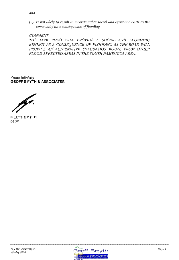
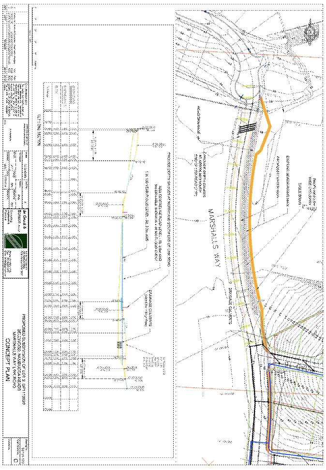
Ordinary Council Meeting 12
June 2014
General Manager's Report
ITEM 9.4 SF25 120614 Donation to St Patrick's Primary
School Biennial Fete
AUTHOR/ENQUIRIES: Michael Coulter, General Manager
|
Summary:
A summary is
not required.
|
|
Recommendation:
That
Council make a donation of $100 to the St Patrick’s Primary School Biennial
Fete.
|
OPTIONS:
Council can
choose to make no donation or provide a donation of a different amount to that
recommended.
DISCUSSION:
Council has
been asked to support the St Patrick’s Primary School Biennial Fete.
A copy of the
letter from the School’s Parents and Friends Association is attached.
It has been
confirmed that the Fete is to be held on 14 November 2014.
It is recommended
that Council make a donation of $100.00 to the Fete.
CONSULTATION:
There has
been no consultation in preparing this report.
SUSTAINABILITY
ASSESSMENT:
Environment
There are no
environmental implications.
Social
There are no
significant social implications.
Economic
There are no
significant economic implications
Risk
There are no
risks.
FINANCIAL
IMPLICATIONS:
Direct
and indirect impact on current and future budgets
The proposed
donation will have a minor budgetary impact.
Source
of fund and any variance to working funds
There is no
significant impact on working funds.
Service
level changes and resourcing/staff implications
The advice to
date is that a Council resolution is required for Council to donate any money
not identified in Council’s donations program – whether it be $1 or $100. The
overhead cost of preparing this report has probably exceeded the recommended
donation.
Attachments:
|
1
|
13914/2014 - Request for Donation - St
Patrick's Primary School Biennial Fete
|
|
|
Ordinary Council Meeting - 12 June 2014
Donation to St Patrick's
Primary School Biennial Fete
|
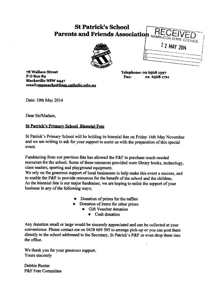
Ordinary Council Meeting 12
June 2014
General Manager's Report
ITEM 9.5 SF770 120614 IPART - Draft Report on Local
Government Compliance and Enforcement
AUTHOR/ENQUIRIES: Michael Coulter, General Manager
|
Summary:
The
Independent Pricing and Regulatory Tribunal (IPART) was asked by the NSW
Government to investigate Local Government compliance and enforcement
activity as part of their drive to reduce “red tape” costs for business and
the community.
IPART have
made 39 recommendations to reduce “red tape” costs to business and the community.
Some of the recommendations have relatively minor potential benefits whilst
others are more significant.
The IPART
report recommends reforms to increase the level of consistency,
co-ordination, co-operation and harmonisation amongst councils in undertaking
their regulatory roles. At the same time the report recognises the need to
reflect local preferences in council approaches where appropriate. The
report also highlights examples of regulatory best practice provided by
stakeholders.
|
|
Recommendation:
That
Council make a submission to IPART advising that it supports its
recommendations to remove “red tape” from Local Government compliance and
enforcement but queries whether in relation to the planning system there
should be a higher priority directed to moving more domestic scale
construction into the categories of exempt and complying development.
|
OPTIONS:
Council can
elect to make a submission in response to IPART’s draft report as it sees fit.
Council also has the option of making no submission.
DISCUSSION:
The
Independent Pricing and Regulatory Tribunal (IPART) has been asked by the NSW
Government to examine Local Government compliance and enforcement activity and
provide recommendations to the NSW Government that would reduce “red tape”
costs for business and the community.
IPART has now
released a draft report which it estimates will:
· Reduce
red tape to business and individuals by at least $177.7 million per year
· Save
councils approximately $42.2 million per year
· Save
the NSW Government about $1.3 million per year
· Provide
net benefits to the community of NSW of $220.5 million per year
IPART’s
investigation revealed that NSW councils play an important role as regulators
of local communities across the State. Councils have 121 regulatory functions,
involving 309 separate regulatory roles, emanating from 67 State Acts which are
administered by approximately 31 State agencies.
There is some
interesting discussion in the report about the need to build council capacity
and capability which reflect some of the observations of the Independent Local
Government Review Panel.
“The
capacity and capability of councils to efficiently undertaken their regulatory
responsibilities can vary across councils. The regulatory challenges can also
vary…
Regardless,
a consistent concern amongst all stakeholders (council and non-council) was the
capacity and capability of councils to undertake their regulatory roles
effectively and efficiently. Lack of resources and expertise can add
considerably to costs through delays; poor decision making; inconsistent,
incorrect or unclear advice; inaction; and overly prescriptive or conservative
approaches to regulation.
…Consistency
of approach is more challenging with 152 different council regulators, than
with a single State agency regulator..” (pages 10 and 11 of the Executive
Summary).
A summary of
IPART’s finding are incorporated in a short fact sheet which is attached
to this report. The full report which runs to 342 pages has not been included
as an attachment but can be found on IPART’s website.
The draft
recommendations that account for the largest reductions in red tape are:
· $59.2m
per year saved in improving road access for heavy vehicles. Potentially the
gains are far larger, with heavy vehicle access restrictions estimated to cost
$366m per year in NSW.
· $36m
per year saved by preventing councils from imposing conditions of consent above
what is required by the Building Code of Australia
· $19.4m
per year saved in implementing a partnership arrangement between the NSW
Department of Planning and Infrastructure and Local Government, with net benefits
of $17.9m per year. There are substantial additional benefits possible from
continued improvements in planning, with the excessive costs associated with
planning estimated to be in the order of about $300m per year.
The IPART
review reinforces the need for more effective partnerships across Councils.
“In order
for the State and councils to develop stronger, more effective partnerships,
there is a need to stronger inter-council structures (or collaborative
arrangements), particularly in the compliance and enforcement area. It is not
possible to effectively consult and partner with 152 separate councils. There
is greater potential for consistency of approach and efficient regulation if
the State can partner with collaborative entities (often with a regional basis)
or Local Government NSW. (page 13 of executive summary).”
The report
notes that a lack of council capacity and capability, as well as consistency
and cooperation, are cited by stakeholders as major sources of unnecessary
regulatory costs and red tape.
“Enhanced
council collaboration can potentially improve each council’s regulatory
capacity and capability, as well as regulatory consistency and cooperation
across councils. Therefore, there are potentially significant benefits from
this.
Such
collaboration can reduce costs to councils and the regulated community through:
o Allowing
councils to realise economies of scale in the provision of regulatory services
o Reducing
delays
o Enhancing
consistency (eg, in relation to forms, guidance, decisions)
o Councils
recognising each other’s approvals (avoiding the need for businesses to submit
multiple applications).
This is
supported by results of council collaborative arrangements, both in the United
Kingdom and Australia.” (page 101).
The report
includes reference to the Quality Regulatory Services Initiative of the State
Government which is a best practice template to promote more efficient
regulation (page 157). It provides as follows:
Quality
Regulatory Services Initiative
Enable
electronic transactions
The
government will ensure all regulators, by the end of 2013, enable electronic
transactions with business including allowing business to lodge or renew
applications and update their details electronically; accept electronic
payments; and access reporting templates and lodge reports electronically.
These actions will result in significant time savings and improved convenience
for business.
Provide
clarity in processing times
The
government will also target processing timeframes in 2013, working will all
regulators to ensure they set, communicate and report on maximum timeframes for
the processing of all licence, authorisation and permit applications.
Provide
transparent appeal mechanisms
By the end
of 2013, all regulators will need to ensure they have transparent appeal
mechanisms, and provide information about them when communicating with business
about licensing, compliance and enforcement decisions.
Promote
a risk-based approach to compliance and enforcement
The
Government will also promote a risk based approach to compliance and
enforcement so that business will no longer be inconvenienced by unnecessary
compliance requirements, saving them time and money that can be redirected into
growing their business. The Government will provide guidance to regulators on
how to implement risk based compliance and enforcement in order to provide a
consistent and transparent approach. All regulators will, by the end of 2014,
publish and commence applying a risk based approach to regulation.
Require
a greater focus on regulatory outcomes
The
Government will also require regulators to focus more strongly on regulatory
outcomes by requiring regulators, by the end of 2014 to have clearly defined
outcomes, commence reviewing their outcome monitoring mechanisms as part of
regular legislative reviews and commence reporting regularly on their outcomes.
This will promote compliance activity that achieves outcomes, rather than just
enforcement outputs (eg, number of inspections), provide greater flexibility for
business in complying with regulation, and help with the evaluation of
regulatory effort. Guidance will be provided to regulators on measuring the
outcomes of regulation in order to help them achieve this goal.
A summary of
the three major recommended reductions in red tape is as follow.
The
Regulatory Framework for Road Transport
Vehicles can
be loosely divided into 2 categories being General Access Vehicles (GAVs) which
include cars, buses, vans and trucks up to 19 metres in length and 42.5 tonnes in
mass.
Restricted
Access Vehicles (RAVs) are any vehicles outside these dimensions and include
vehicles such as B-Doubles and Road Trains. RAVs face limitations on how they
are able to access the road network.
Under Section
7 of the Roads Act 1993 (NSW), councils are the road authority for local and
regional roads within their Local Government area. As a result they are
responsible for funding and conducting the ongoing maintenance of nearly 90% of
NSW’s road network and approving access by heavy vehicles. In particular this
means that they are the approving authority for RAVs that wish to use local or
regional roads. As the approving authority, councils can place conditions on
heavy vehicle access, such as hours of operation or weight restrictions. Most
freight movement requires the use of a local road during picking up or dropping
off a load, also known as the first and last mile issue.
Stakeholder
submissions on this matter to IPART focused on the inability of councils to
conduct road engineering assessments leading to costly delays; the perceived
excessive bias of councils towards safety, noise and congestion concerns
compared to the economic benefits of increased heavy vehicle access, when
making road access decisions; and the inconsistencies in council decisions.
(page 259)
IPART has
determined that freight and logistics form a sizeable portion of the national
economy and unnecessary regulatory burdens in this area impose significant
costs. IPART’s draft recommendation is that the NSW Government:
· Notes
the potential red tape savings and net benefits that could accrue to NSW
through the National Heavy Vehicle Regulator (NHVR) providing:
o Technical
assistance to councils in certifying local roads for access by heavy vehicles,
and
o Guidelines
to councils for assessing applications for heavy vehicle access to local roads
in relation to potential amenity and safety impacts; and
· In
the event of delay in the NHVR providing these elements of the national
reforms, funds an interim unit to provide this assistance to Local Government.
Addressing
Regulatory Creek in Building and Construction
The Building
Code of Australia (BCA) outlines the minimum standards that buildings must meet
in order to be considered fit for occupation. However, the Productivity
Commission and various stakeholders have noted that councils often impose
additional requirements over and above the BCA in their conditions of consent
for development approval. These changes include design matters such as
increased ceiling height requirements, reduction in external noise or improved
disability access. According to the Australian Building Codes Board, “such
interventions significantly impact on housing affordability”. (page 221)
IPART’s draft
recommendation is that Councils seeking to impose conditions of consent above
that of the Building Code of Australia must conduct a cost benefit analysis
justifying the benefits of these additional requirements and seek approval from
an independent body, such as IPART, under a “gateway” model.
The practice
of this Council is not to impose additional requirements over and above the BCA
in building related conditions of consent. Therefore the draft recommendation
will not affect the operations of Council.
Partnership
arrangement between the NSW Department of Planning and Infrastructure and Local
Government
The proposed
arrangements are less precise than other recommendations. IPART believes there
is benefit in the Department of Planning and Infrastructure adopting a
comprehensive regulatory partnership model, including a dedicated Local
Government Unit. They believe that this will help in:
o Achieving
more consistent regulatory instruments, approaches and decisions
o Promoting
a risk based approach to regulation, targeting or prioritising efforts
o Achieving
better compliance and enforcement of planning laws by working more closely with
councils
o Providing
information and ongoing support to councils from the Department of Planning and
Infrastructure and feedback from councils on the quality and usefulness of this
support
o Getting
“buy in” from councils in adopting DoPI guidance and advice
o Monitoring
of councils’ regulatory performance, and working with councils to improve
performance.
IPART cite
potential applications of the Partnership Model. A dedicated Local Government
unit within the Department of Planning and Infrastructure could:
· Enhance
standardisation and consistency of planning information, including the
development of standard forms
· Promote
best practice in how council’s approach and administer planning regulation
· Regularly
consult with LG NSW and other stakeholders
· Ensure
compliance with planning legislation
· Tailor
council reporting requirements
· Provide
feedback and where necessary, assistance to councils based on reported data
· Provide
guidance on setting regulatory fees
· Promote
and encourage sharing of regulatory resources
· Assist
councils who may have insufficient capacity
Of course
progress in reducing “red tape” costs associated with the planning system
largely depends on the on-going reform of the planning system. The attention
over the past 10 years has been in “standardising” the system with the roll out
of the standard LEP and definitions. Despite the huge application of
resources, it is queried whether that much has been achieved. To some extent
IPART are proposing more of the same. It is suggested that more attention
needs to be given to getting minor domestic scale construction out of the
system by way of exempt and complying development.
Other
Recommendations
IPART make
some observations about companion animal management.
According to
the Division of Local Government, councils are under no statutory obligation to
accept or take care of pets after hours. However, at least 1 Council informed
IPART that animal welfare organisations and police routinely (but wrongly)
inform community members that councils are the responsible authority.
Newcastle
City Council also noted that barking dogs create the highest number of
complaints between neighbours every year with over 3,000 complaints generated
per year in that LGA alone.
IPART also
reports on the low registration rate for companion animals with approximately
50% of all pets in NSW unregistered. Only 62% of dogs and 44% of cats were
fully registered. This in turn leads to a waste of council resources, higher
euthanasia rates and a loss of revenue for councils. Not surprisingly
stakeholders took issue with the 2 step registration process, with many owners
wrongly believing that a microchipped animal was registered.
It was
reported that many owners, whilst being aware that registration is a separate
step to microchipping, do not fulfil their statutory obligations to do so
because it is too difficult to go to their local council during working hours
to complete the registration form. There are currently no on-line options for
registration – possibly because councils require evidence of desexing,
pensioner concessions and to ensure the animal is not already registered to
someone on the State wide companion animals register. Life time registration
for a desexed animal is $49.00 but with a pensioner concession it is $19.00.
With complex regulatory systems, consideration needs to be given as to whether
relatively minor concessions are worth not only the additional administrative
work but the inconvenience to all residents in having to visit their Council
during business hours to achieve registration of their pet.
CONSULTATION:
There has
been no consultation in the preparation of this report.
SUSTAINABILITY
ASSESSMENT:
Environment
The report by
IPART concerns the “trade off” which is made in any regulatory system between
the desired policy outcome and the regulatory costs of achieving that. This
applies to all of Council’s quadruple bottom line considerations, ie
environment, social, economic and risk.
Social
Some of the
regulatory systems which Council implement are based on strong community
feelings. For example the regulatory framework for pool fences has arisen out
of the many toddler drownings in backyard pools. Similarly the regulations in
relation to dangerous dogs have arisen out of many dog attacks, some of which
have been fatal to young children.
Economic
The economic
costs of regulation are well documented in the IPART report.
Risk
The
consideration of risk typically involves a matrix which weighs consequence and
likelihood.
IPART have
questioned those areas of regulatory endeavour which seem to be directed to
ill-defined amenity issues as opposed to more quantifiable risks to life and
property.
FINANCIAL
IMPLICATIONS:
Direct
and indirect impact on current and future budgets
There is no
budgetary impact.
Source
of fund and any variance to working funds
There is no
impact on working funds.
Service
level changes and resourcing/staff implications
At this stage
there are no service level changes or implications.
Attachments:
|
1
|
14154/2014 - Draft Report Summary - Local
government compliance and enforcement
|
|
|
Ordinary Council Meeting - 12 June 2014
IPART - Draft Report on
Local Government Compliance and Enforcement
|


Ordinary Council Meeting 12
June 2014
General Manager
ITEM 9.6 SF839 120614 Annual
Reporting of Contracts for Senior Staff
AUTHOR/ENQUIRIES: Michael
Coulter, General Manager
|
Summary:
Section 339
of the Local Government Act requires that the General Manager must, at least
once annually, report to the council on the contractual conditions of senior
staff (ie by 30 June).
The General
Manager, Assistant General Manager Engineering Services and Assistant General
Manager Corporate Services are Council’s designated senior staff positions.
|
|
Recommendation:
That the information
concerning the provisions of the employment contracts for the General
Manager, Assistant General Manager Engineering Services and Assistant General
Manager Corporate Services be received.
|
OPTIONS:
There are no
options. The report is for information.
DISCUSSION:
Section 339
of the Local Government Act requires that the General Manager must, at least
once annually, report to the council on the contractual conditions of senior
staff (ie by 30 June).
There is no
other information as to what actually has to be reported but the Division of
Local Government in its Better Practice Review Program indicates that better
practice is for the report to contain:
· A
list of senior staff
· The
specific term of each contract and when it was entered into
· The
value of the remuneration package and any variations that have been made in the
past year or which are proposed for the ensuing year
· The
timing and outcome of any performance assessments that were undertaken
· A
copy of any performance agreement entered into for the current year and/or
proposed for the ensuing year, and
· Details
of any other “material” matters. These could include any requirement for the
General Manager or other senior staff member to advise if she/he is seeking an
extension of the current contract or reappointment for a further term and
similarly, any requirement for the Council to advise the General Manager/senior
staff member of any intention not to renew their appointment and/or readvertise
the position.
The following
information is provided in response to these “dot” points.
Senior
Staff
Mr Michael
Coulter, General Manager
Mr Paul
Gallagher, Assistant General Manager Engineering Services
Mr Scott
Norman, Assistant General Manager Corporate Services
Contract
Term and Date Entered Into
General
Manager – contract commenced 1 April 2011 for a 5 year term
Assistant
General Manager Engineering Services – contract commenced 10 January 2011 for a
5 year term
Assistant
General Manager Corporate Services - contract commenced 23 September 2013 for a
5 year term
Value of
the Remuneration Package and any variations made in the past year
General
Manager - $214,558.88 (inclusive of superannuation and vehicle)
The salary
component of the package was increased by the regulated increase for the SES of
2.5% on 1 April 2014.
Assistant
General Manager Engineering Services - $176,828.67 (inclusive of superannuation
and vehicle)
The salary
component of the package was increased by the regulated increase for the SES of
2.5% on 10 January 2014.
Assistant
General Manager Corporate Services - $167,587 (inclusive of superannuation)
The Timing
and Outcome of any Performance Assessments
General
Manager – performance assessment undertaken on 13 March 2014 – outcome
“satisfactory”.
Assistant
General Manager Engineering Services – performance assessment undertaken on 7
February 2014 – outcome “satisfactory”.
Copy of
Performance Agreements
The
performance agreements are largely standard templates with a large number of
management objectives and performance measures. Of most significance are the
priorities for the ensuing year.
The agreed
priorities for the General Manager are:
· More timely staff responses to written correspondence
· Progression with Council’s Internal Audit processes
· Development of a rating strategy
· Further development of Council’s website
The
agreed priorities for the Assistant General Manager Engineering Services are:
· Maintaining low revotes
· Further development of an asset management system
· Maintaining service levels with retiring senior staff and
team leaders
· Assisting with planning for any structural changes; ie Joint
Organisations (arising from recommendations of the Independent Local Government
Review Panel)
The
agreed priorities for the Assistant General Manager Corporate Services are:
· Develop strategic corporate and financial planning
objectives that reflect the reasonable expectations of the community and
support Council’s decision making processes
· Sustain a high level of customer satisfaction through
consistent quality service delivery
· Implement cost effective information technology
· Develop business services unit
· Continuous improvement – undertake reviews of functions and
processes in Corporate Services to improve efficiency and effectiveness.
Other
Material Matters
Nil
CONSULTATION:
There has
been no consultation in preparing this report.
SUSTAINABILITY
ASSESSMENT:
Environment
There are no
implications for the environment.
Social
There are no
social implications.
Economic
There are no
economic implications.
Risk
There are no
particular risks.
FINANCIAL
IMPLICATIONS:
Direct
and indirect impact on current and future budgets
There is no
budgetary impact. The remuneration packages are listed in the report.
Source
of fund and any variance to working funds
There is no
impact on working funds.
Attachments:
There are no attachments for this report.
Ordinary Council Meeting 12
June 2014
General Manager's Report
ITEM 9.7 SF1232 120614 Pelican Park - Review of On Site
Sewerage Management System
AUTHOR/ENQUIRIES: Anthony Brandie, Senior Health and Building Surveyor; Michael
Coulter, General Manager
|
Summary:
This report
presents a comprehensive audit of the on-site sewerage management system(s)
servicing the premises known as Pelican Park carried out by Whitehead and
Associates Environmental Pty Ltd. The audit report lists a suite of
recommendations which are supported.
|
|
Recommendation:
1. That the
on-site sewerage management system licences for the Park be renewed for 6
months incorporating those recommendations in the Whitehead and Associates
report that relate specifically to the management of the system and its
components being:
· A maintenance contract is to be signed by the park owners with a
reputable servicing agent. Quarterly inspections must be undertaken as well
as an annual report to Council;
· 6 monthly effluent grab samples are to be collected and analysed for
TSS, BOD, FC and residual Cl;
· The treatment systems and pump-wells are to be repaired by pump out,
alarm repair, chlorination repair etc, as noted in the report;
· To ensure that the risks to offsite receptors are reduced, within a
reasonable period ultraviolet lamps are to be installed on both treatment
plants to ensure that disinfection is occurring;
· To ensure effluent from the top LAA is not being pumped to the lower
LAA;
· Placement of a run-on berm between the bottom LAA and the Pacific
Highway;
· Repair of the top OSMS by removing any flood or spray application
hoses, or taps, and installing surface mulch covered drip lines on the
vegetated northern boundary and embankment area near the top amenities; and
· Placement of signage at all LAA’s to warn users of the irrigation of
effluent.
2. That Council staff investigate and report
to Council within 6 months, the viability of a low pressure or vacuum sewer
or any other option so as to enable the caravan park to be connected to
Council’s sewerage system at Bellwood. The report is to include options to
finance the work and the contributions expected from the caravan park and
other property owners who may benefit.
|
OPTIONS:
The findings
of the report from Whitehead and Associates are such that there is not considered
to be a “do nothing” option. There is the option of a Wisconsin sand mound as
an alternative to a connection to the sewerage system. However further
investment in on-site sewage management arrangements does have risk if
ultimately, for whatever reason, the system does not provide the required
performance.
DISCUSSION:
Pelican Park which is located at 5982 Pacific Highway, Nambucca
Heads is licensed to operate as a caravan park and camping ground with 89 sites
comprised of 28 long term or permanent sites, 40 short term sites and 21
camping sites.
The site is connected to Council’s town water system and relies on
on-site effluent treatment and disposal.
The Park is subject to a licensing arrangement with Council for both
the operation of the caravan park and the operation of its on site sewerage
management systems. These licensing arrangements are set out in the Local
Government Act, 1993.
The on-site sewerage licences for the Park have expired and require
renewal.
The Caravan
Park and Camping ground licence is set to expire on 31 December 2014.
The site is high risk for on-site treatment and disposal of sewerage
given, amongst other things, the flood prone nature of the site, the proximity
to oyster aquaculture areas on the Nambucca River and the nature of the land
use.
A proposed
upgrade of the system was submitted to Council on 21 August 2009 by Rosewood
Environmental Services as a result of concerns from Council. The site is within
the referral range for on-site sewerage activities to the Department of Primary
Industries who administer State Environmental Planning Policy 62 – Sustainable
Aquaculture.
Given some of
the complexities associated with the site, risk exposure to Council and the
desire to arrive at an outcome, Whitehead and Associates Environmental
Consultants were engaged to review and report on both the Rosewood report and
the existing on site system(s) servicing Pelican Park. The final report dated
23 May 2014 is attached.
The report
identifies many areas of non-compliance and failures of the system from both a
management and maintenance perspective.
The following
clarifies some acronyms in the Whitehead and Associates report;
SSI -
Sub-Surface Irrigation.
LAA – Land
Application Area.
LPED – Low
Pressure Effluent Distribution.
CONSULTATION:
The
Department of Primary Industries have ongoing concerns about the on-site
sewerage management system at Pelican Park, particularly risks associated with
the adjoining oyster aquaculture area. The preparation of the subject audit
report was supported by Primary Industries.
The NSW
Ministry of Health have expressed similar concerns. They also supported the
preparation of the audit report.
SUSTAINABILITY
ASSESSMENT:
Environment
The Whitehead
and Associates report identifies existing poor practices and limiting site
constraints. Incorporation of those recommendations that relate to the
management of the system and its components into the licensing arrangement for
the on-site sewerage management system(s) on site will see improved environmental
outcomes through enforcement. Failure to effectively manage this issue will
have short and long term environmental impacts on the local environment. There
are numerous examples of the impact of poorly treated effluent and urban runoff
on the estuary environment. Some of these have affected human health (eg
Wallis Lake) whilst others have ended oyster production through the
introduction of viral pathogens (eg Hawkesbury River, Georges River, the Kalang
River).
Social
Failure to
meet the required environmental outcomes for effluent management may lead to
the displacement of some or all of the Park’s permanent residents.
Economic
The economic
impacts relate to the future of the caravan park.
Risk
As Council is
the regulator with this matter, failure to effectively manage the existing risk
may expose Council to liability through negligence. Where human health and the
future of the local oyster industry is at stake, the legal consequences of
inaction could be very significant.
FINANCIAL
IMPLICATIONS:
Direct
and indirect impact on current and future budgets
At this stage
there is no budgetary impact.
Source
of fund and any variance to working funds
At this stage
there is no impact on working funds.
Service
level changes and resourcing/staff implications
There will be
considerable work required by Council staff to investigate and report on the viability of a low pressure or vacuum sewer or any other option so
as to enable the caravan park to be connected to Council’s sewerage system at
Bellwood.
Attachments:
|
1
|
15663/2014 - Pelican Park - Whitehead
& Associations Final Report
|
|
|
Ordinary Council Meeting - 12 June 2014
Pelican Park - Review of
On Site Sewerage Management System
|


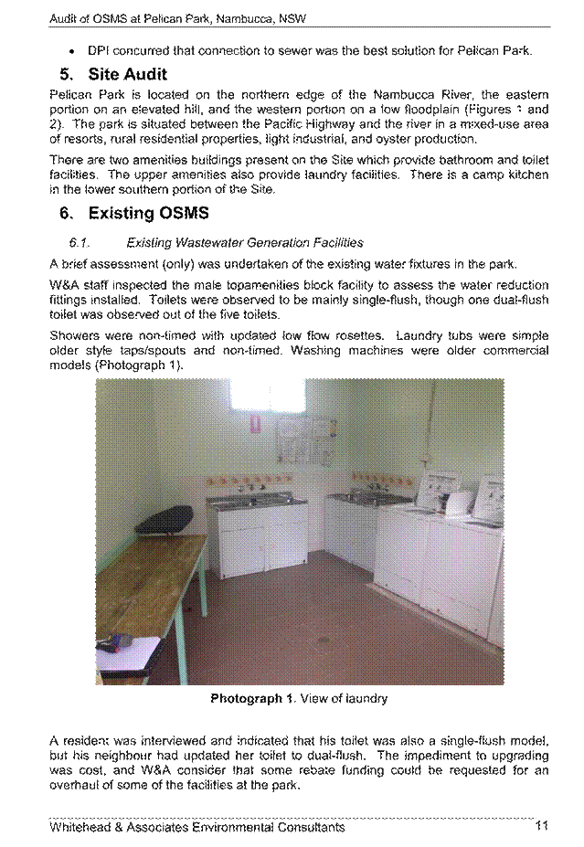
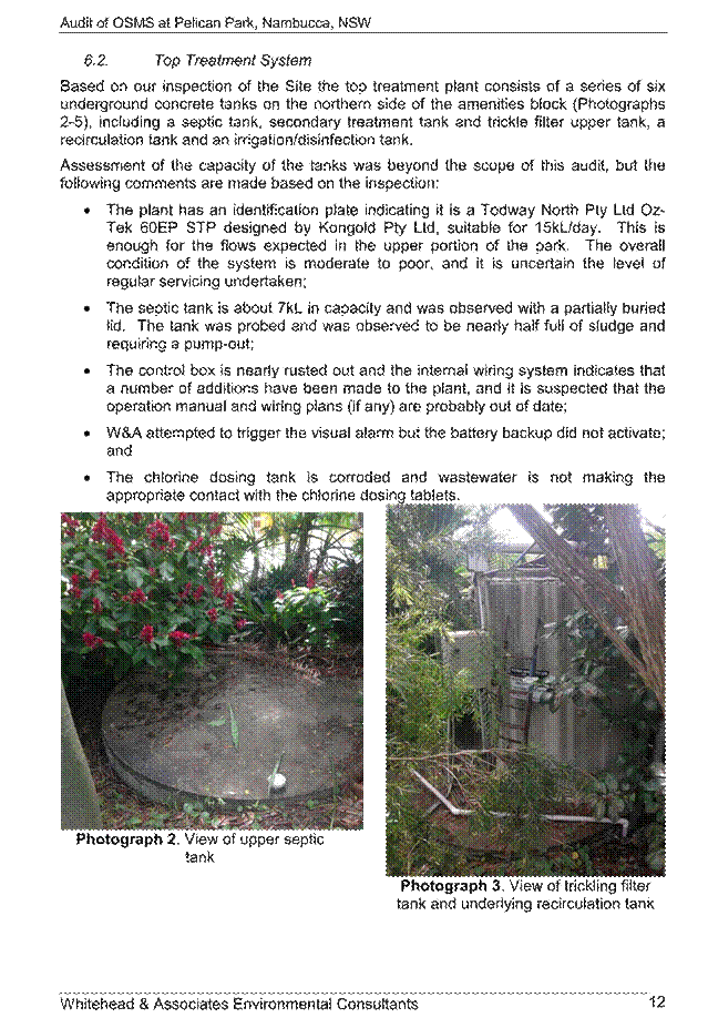
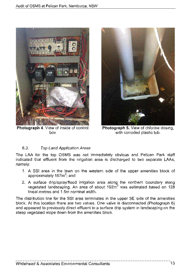


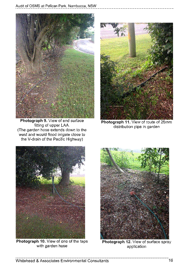


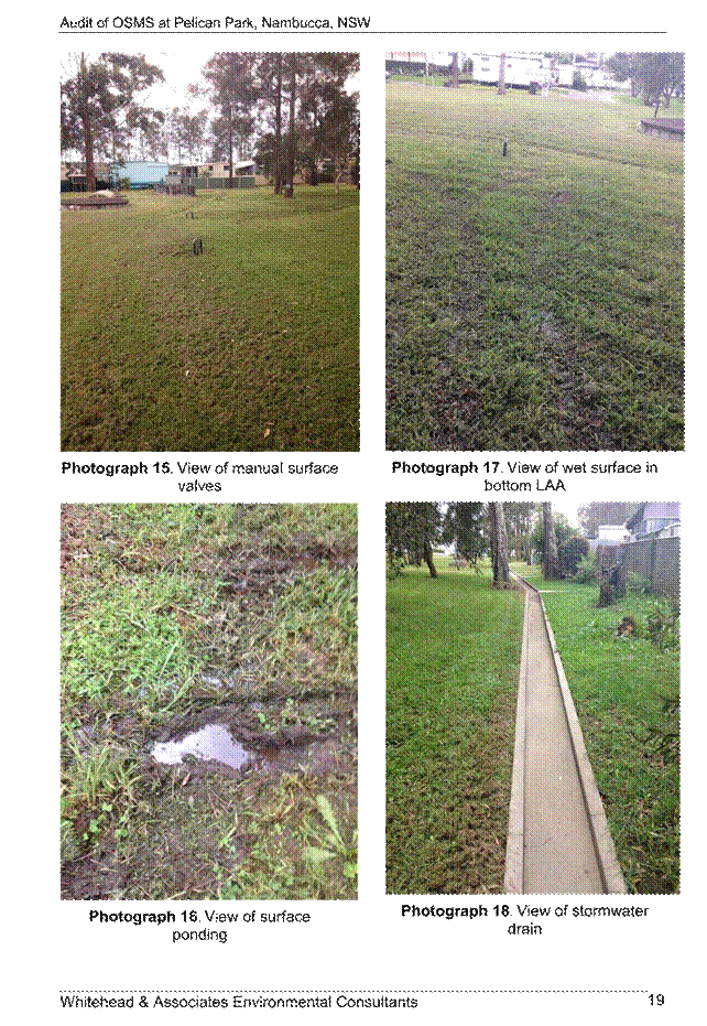
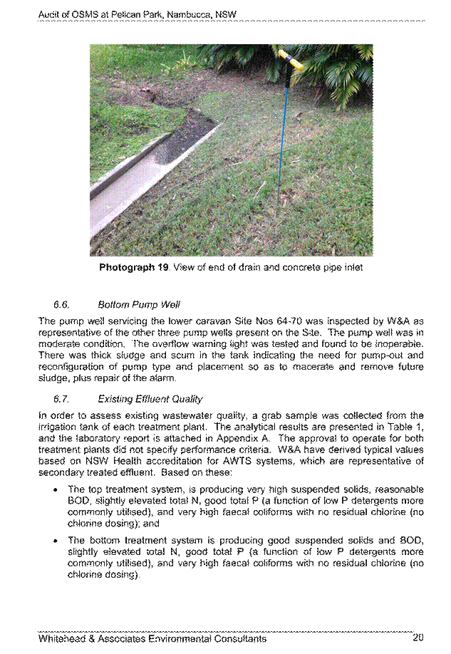


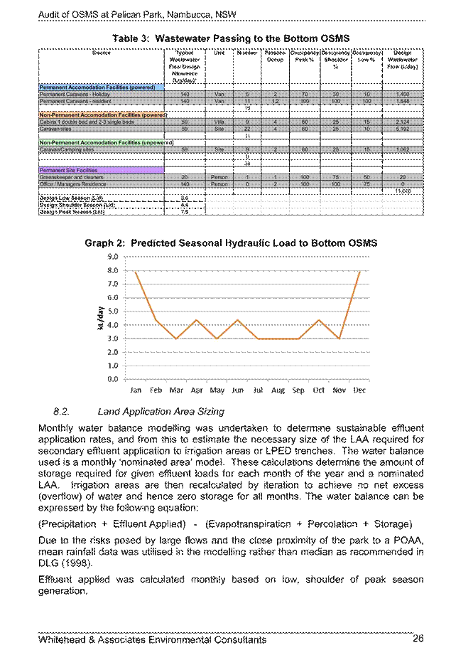
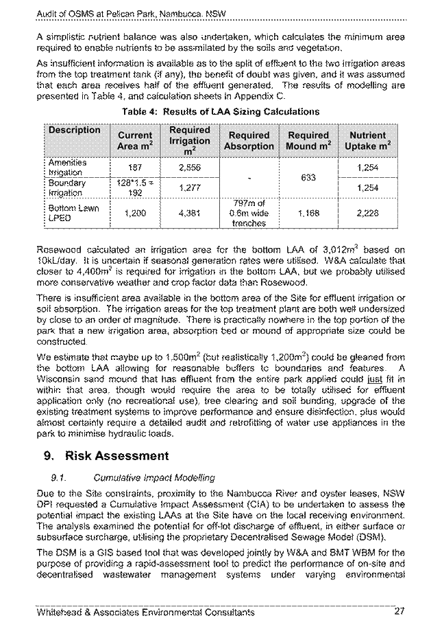


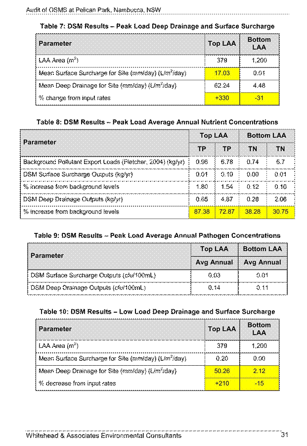
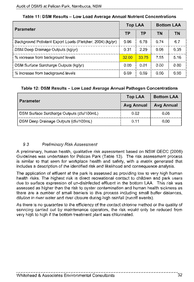
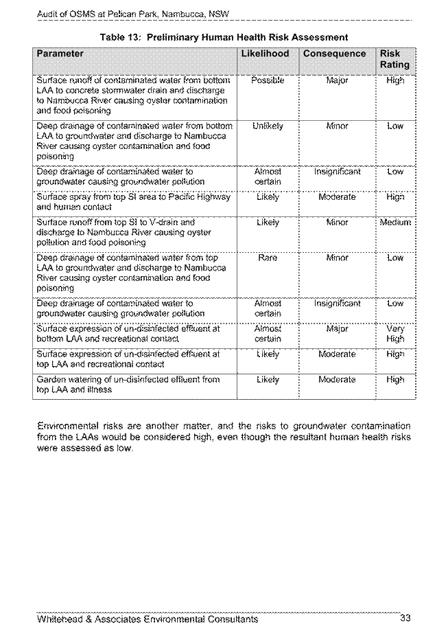


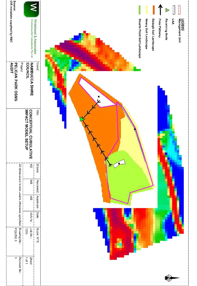

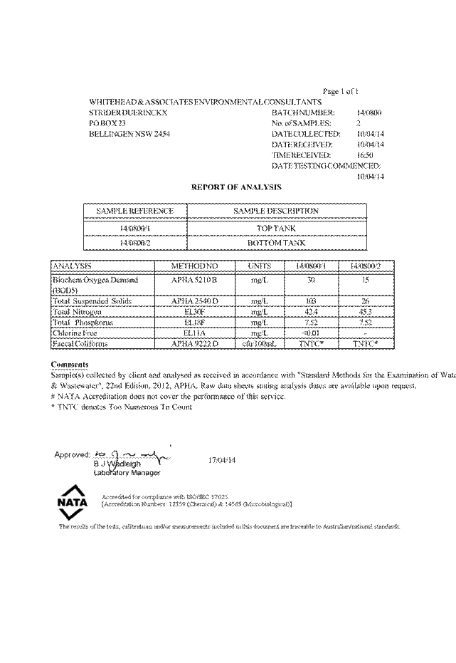

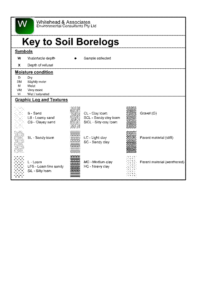
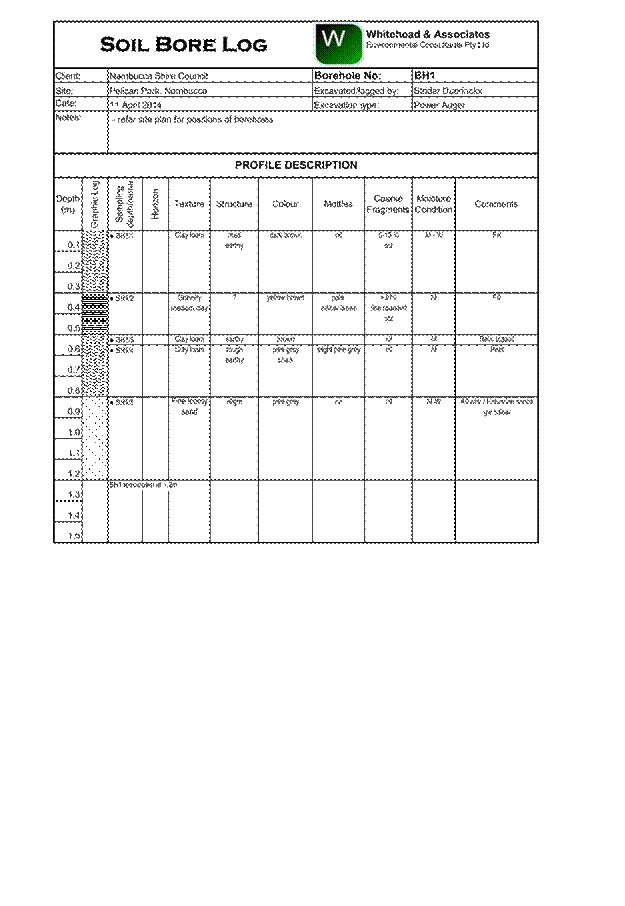


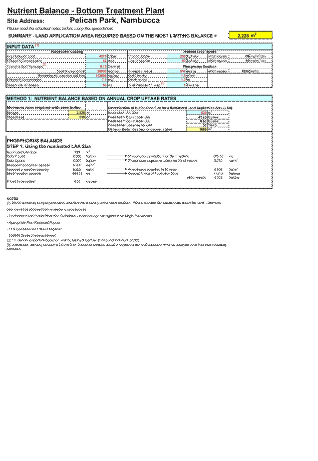


Ordinary Council Meeting 12
June 2014
General Manager's Report
ITEM 9.8 SF1947 120614 Outstanding
DA's greater than 12 months, applications where submissions received not
determined from 21-31 May 2014
AUTHOR/ENQUIRIES: Lorraine
Hemsworth, Executive Assistant
|
Summary:
In accordance with Council
resolution from 15 May 2008 meeting, the development applications listed
below are in excess of 12 months old (Table 1) (One application is in excess
of 12 months old).
Table 2 is development
applications which have been received but not yet determined due to
submissions received. In accordance with Minute 848/08 from Council meeting
of 18 December 2008, should any Councillor wish to “call in” an application a
Notice of Motion is required specifying the reasons why it is to be “called
in”.
If an application is not called
in and staff consider the matters raised by the submissions have been
adequately addressed then the application will be processed under delegated
authority. Where refusal is recommended the application may be
reported to Council for determination.
|
|
Recommendation:
That the applications where
submissions have been received be noted and received for information by
Council.
|
TABLE 1: UNRESOLVED
DEVELOPMENT APPLICATIONS IN EXCESS OF 12 MONTHS OLD
|
DA NO
|
DATE OF RECEIPT
|
PROPOSAL
|
PROPERTY DESCRIPTION
|
SUBMISSIONS RECEIVED/
STAFF COMMENTS
|
|
2012/011
|
03/02/2012
|
Nambucca
Gardens Estate 346 Lot Residential Subdivision with Residue, Associated Works
– Staged
|
Lot 2 DP
1119830, Alexandra Drive, Bellwood
|
134 public submissions
Submissions
outlined in previous report to Council 27 September 2012 – Item 10.1
Voluntary
Planning Agreement supported by Council at its 28 February 2013
meeting.
Meeting with
applicant and planning agreed that Council would assess its section of the
link road under Part 5 of the EPAA. Concept plan for Link Road currently
being prepared for assessment. Will be exhibited with VPA.
Status report
to Council meeting 16 October On-site briefing meeting held with JRPP 18
October 2013 – advice to be sought from applicant.
Report in
Business Paper of 13 Nov 2013.
As at 6 May
2014 consultant preparing report for JRPP.
Refer to
Report this meeting
Tabling of
report to JRPP
|
Please note that there is two
unresolved Development Applications in Excess of 12 months old.
TABLE 2: DEVELOPMENT
APPLICATIONS WHERE SUBMISSIONS HAVE BEEN RECEIVED AND ARE NOT YET DETERMINED
|
DA NO
|
DATE OF RECEIPT
|
PROPOSAL
|
PROPERTY DESCRIPTION
|
SUBMISSIONS RECEIVED/
STAFF COMMENTS
|
|
2013/092
|
29/08/2013
|
Health Services Facility & Subdivision
|
Lot 1 DP 1004209 & Lot 22 DP 1161807, Centenary Parade,
Nambucca Heads
|
4 public submissions
· Zoned
community land and should be left that way.
· Should be
located closer to other health facilities or other appropriate zonings
· Only one
entry and exit road (Centenary Parade) therefore increasing traffic to area
and can be dangerous with lots of school children. Issues with emergency
evacuations
· Parking
an issue during carnivals etc
· Little
consultation into the development of this Health Care Centre - request for
dialysis services to be included in the new centre
· Existing
levels and types of crimes already in area maybe exacerbated
· Re-zoning
costs borne by Council not required for alternate sites
· Request
for further consultation with police, schools, school bus providers and other
primary health providers for another site
Matters pertaining to comments on the submissions
particularly the type of health services provided and need for, car parking
and traffic – Referred to Applicants Consultant
In principal support provided by Council. LEP Amendment
referred to DOP for consideration. Conditions forwarded to applicant for
consideration by the Crown.
Awaiting Planning Proposal and resolution of land sale
|
|
2013/170
|
18/11/2013
|
Boundary
Adjustment, shed, operate depot
|
Lot
2 DP 881651, 296 Valla Road, Valla
|
11 public submissions
X2 supporting application
· Land
zoned Agricultural/Rural and this is to establish an Industrial enterprise
· Industrial
site planned for the Cow Creek area and this is where should be located
· More than
enough trucks on Valla Road especially with the application for the Valla
Quarry being considered with more trucks
· Applicant
owns very large machinery
· Increase
in residential numbers over the past years therefore increase in vehicles and
these will have to compete with industrial vehicles
· Increase
in noise and dust
· If
granted, potential to cause a decrease in the value of the land
· Water
issues – drains directly into Deep Creek and floods are observed frequently
on this land
· Air
quality reduced by dust and toxics
· Green
fill would be odorous – comparable to a rubbish tip
· Valla
Road is not coping with current usage with pot holes – stone chips are common
· No
compatibility of the proposal to adjoining grazing properties
· No
mention of 2 operations involving use of concrete crusher and greenwaste tub
grinder which is exceedingly noisy
· Disagree
with “development compatible with adjoining neighbours”
· Feeders –
running times and how monitored, location
· No
selling of materials – secondary aggregate is valuable commodity
· Water
pollution
· Most
properties in neighbourhood are rated Residential/Village Estate not
compatible to industrial
· Directors
do not reside near property so removed from noise pollution
· Visual
amenity
· Staff
amenities not appear convenient for industrial use
· Unsupported
by adequate environmental impact studies
· Council
setting precedent for the use of vital agricultural land
· Industry
to be kept to industrial estates
· Proposed
location on prime agricultural
· Lose of
peace and quiet and atmosphere
· SOEE
· Small
vegetable garden near by
· No
adjoining properties have similar development – how compatible
· Servicing
of site for plant and vehicles – what petroleum being used and storage
· Drainage
bunded to prevent fuels into water table
· What sort
of clean fill
· Recycled
materials being used – what
· ? weekday
will allow for non impact crushing and plant operation
· Construction
of sediment ponds
· Rubbish –
increase in traffic
This application has been “called-in” for
determination by Council
Further submissions received
43 public submissions – points as mentioned above
X4 supporting application
Awaiting RFS response
|
|
2014/001
|
02/01/2014
|
Tourist Accommodation
|
Lot
3 DP 1035204, Seascape Place, Scotts Head
|
1 submission received and requested that content remain
confidential
Information received – waiting Rural Fire Service response
|
Attachments:
There are no attachments for this report.
Ordinary Council Meeting 12
June 2014
General Manager's Report
ITEM 9.9 SF1148 120614 Council
Ranger's Report May 2014
AUTHOR/ENQUIRIES: Teresa
Boorer, Business Services Officer
|
Summary:
The following is the Council
Ranger’s Report regarding Council’s Companion Animal Activities and listing
of penalty notices issued by both Council’s Rangers for May 2014.
|
|
Recommendation:
That the report for May 2014
be received and noted by Council.
|
|
|
Cats
|
Dogs
|
|
COUNCIL’S
SEIZURE ACTIVITY
|
|
|
|
Seized (doesn’t include those animals dumped or
surrendered)
|
0
|
6
|
|
Returned to Owner
|
0
|
3
|
|
Transferred to - Council's Facility from Seizure
Activities
|
0
|
3
|
|
ANIMALS IN AND
ARRIVING AT COUNCIL'S FACILITY
|
|
|
|
Animals In Council's Facility - (Start of Month)
|
0
|
2
|
|
Abandoned or Stray
|
0
|
3
|
|
Surrendered
|
0
|
3
|
|
Animals transferred from Seizure Activities
|
0
|
3
|
|
Total Incoming Animals
|
0
|
11
|
|
ANIMALS LEAVING
COUNCIL'S FACILITY
|
|
|
|
Released to Owners
|
0
|
4
|
|
Sold
|
0
|
3
|
|
Released to Organisations for Rehoming
|
0
|
0
|
|
Died at Council's Facility(other than euthanased)
|
0
|
0
|
|
Stolen from Council's Facility
|
0
|
0
|
|
Escaped from Council's Facility
|
0
|
0
|
|
Other
|
0
|
0
|
|
EUTHANASED
|
|
|
|
Restricted Dogs
|
|
0
|
|
Dangerous Dogs
|
|
0
|
|
Owner’s Request
|
0
|
2
|
|
Due to Illness, Disease or Injury
|
0
|
0
|
|
Feral/infant animal
|
0
|
0
|
|
Unsuitable for rehoming
|
0
|
2
|
|
Unable to be rehomed
|
0
|
0
|
|
Total Euthanased
|
0
|
4
|
|
Total Outgoing Animals
|
0
|
11
|
|
TOTAL IN COUNCIL'S FACILITY - (END OF MONTH)
|
0
|
0
|
|
May-14
|
|
Parking
|
|
|
|
REGO NO.
|
PN NUMBER
|
INFRINGEMENT
DETAILS
|
PENALTY $
|
Date Sent
|
|
WLS 520
|
3081195801
|
#9246 - Not park rear to kerb
|
101.00
|
12.05.14
|
|
XUC 580
|
3081195810
|
#9246 - Not park rear to kerb
|
101.00
|
12.05.14
|
|
BZA 12Q
|
3081195820
|
#9246 - Not park rear to kerb
|
101.00
|
12.05.14
|
|
AQD 26W
|
3081195839
|
#9246 - Not park rear to kerb
|
101.00
|
12.05.14
|
|
|
|
TOTAL VALUE OF Parking
PENALTIES:
|
404.00
|
|
|
|
|
POEO
|
|
|
|
|
3081195792
|
#6753 - Fail comply Clean up
Notice
|
750.00
|
12.05.14
|
|
|
3081195848
|
#6753 - Fail comply Clean up
Notice
|
750.00
|
12.05.14
|
|
|
3081195857
|
#12572 - Pollute Land -
Individual
|
750.00
|
21.05.14
|
|
|
3081195866
|
#12572 - Pollute Land -
Individual
|
750.00
|
21.05.14
|
|
|
3081195875
|
#12572 - Pollute Land -
Individual
|
750.00
|
21.05.14
|
|
|
|
TOTAL
VALUE OF POEO PENALTIES:
|
3750.00
|
|
|
May-14
|
|
Companion
Animals
|
|
|
|
Microchip
|
PN
NUMBER
|
INFRINGEMENT
DETAILS
|
PENALTY
$
|
Date
Sent
|
|
|
3081196700
|
not prevent dog escape
|
220
|
13/05/2014
|
|
|
3081196719
|
not prevent dog escape
|
220
|
13/05/2014
|
|
|
3081196737
|
not prevent dog escape
|
220
|
13/05/2014
|
|
|
3081196773
|
not prevent dog escape
|
220
|
19/05/2014
|
|
|
|
TOTAL VALUE OF Companion Animals PENALTIES:
|
880.00
|
|
|
May-14
|
|
Parking
|
|
|
|
REGO NO.
|
PN NUMBER
|
INFRINGEMENT DETAILS
|
PENALTY $
|
Date Sent
|
|
AM89LY
|
3081196553
|
stop in bus zone
|
236.00
|
9/05/2014
|
|
BL40NI
|
3081196562
|
disobey no parking
sign
|
101.00
|
9/05/2014
|
|
AF25VA
|
3081196571
|
not park rear to
kerb
|
101.00
|
9/05/2014
|
|
BG37SR
|
3081196580
|
not park rear to
kerb
|
101.00
|
9/05/2014
|
|
AZQ53Q
|
3081196590
|
stop in loading
zone
|
169.00
|
9/05/2014
|
|
BX86DC
|
3081196609
|
disobey no parking
sign
|
101.00
|
9/05/2014
|
|
VQL301
|
3081196618
|
not park rear to
kerb
|
101.00
|
9/05/2014
|
|
BV57BD
|
3081196627
|
not park rear to
kerb
|
101.00
|
9/05/2014
|
|
CM384
|
3081196636
|
stop in bus zone
|
236.00
|
9/05/2014
|
|
MUN001
|
3081196645
|
disobey no parking
sign
|
101.00
|
9/05/2014
|
|
BN38JF
|
3081196654
|
not park rear to kerb
|
101.00
|
9/05/2014
|
|
CPS25H
|
3081196663
|
not park rear to
kerb
|
101.00
|
9/05/2014
|
|
ANR22Q
|
3081196672
|
disobey no stopping
sign-school zone
|
304.00
|
9/05/2014
|
|
MAT400
|
3081196681
|
not park rear to
kerb
|
101.00
|
9/05/2014
|
|
BTJ51C
|
3081196728
|
not park rear to
kerb
|
101.00
|
15/05/2014
|
|
BW73AL
|
3081196746
|
not park rear to
kerb
|
101.00
|
15/05/2014
|
|
WPH216
|
3081196755
|
not park rear to
kerb
|
101.00
|
15/05/2014
|
|
BX79KN
|
3081196764
|
disobey no stopping
sign-school zone
|
304.00
|
15/05/2014
|
|
BFC87W
|
3081196782
|
not park rear to
kerb
|
101.00
|
19/05/2014
|
|
BMZ35B
|
3081196791
|
disobey no stopping
sign
|
236.00
|
19/05/2014
|
|
AL10ZO
|
3081196800
|
stop in disabled
zone permit not displayed
|
506.00
|
19/05/2014
|
|
AL24MP
|
3081196810
|
not park rear to
kerb
|
101.00
|
19/05/2014
|
|
BK47NF
|
3081196838
|
disobey no stopping
sign
|
236.00
|
20/05/2014
|
|
BV95KZ
|
3081196847
|
disobey no stopping
sign
|
236.00
|
20/05/2014
|
|
XBF333
|
3081196856
|
not park rear to
kerb
|
101.00
|
20/05/2014
|
|
BAJ95J
|
3081196865
|
not park rear to
kerb
|
101.00
|
20/05/2014
|
|
ALU05K
|
3081196874
|
not park rear to
kerb
|
101.00
|
20/05/2014
|
|
BT20PO
|
3081196883
|
not park rear to
kerb
|
101.00
|
20/05/2014
|
|
BIV97P
|
3081196892
|
not park rear to
kerb
|
101.00
|
20/05/2014
|
|
YBL181
|
3081196901
|
not park rear to
kerb
|
101.00
|
23/05/2014
|
|
May-14
|
|
Parking (Continued)
|
|
|
|
CND36R
|
3081196910
|
not park rear to
kerb
|
101.00
|
23/05/2014
|
|
XPG993
|
3081196920
|
disobey no stopping
sign-school zone
|
304.00
|
23/05/2014
|
|
ARD67Y
|
3081196939
|
not park rear to
kerb
|
101.00
|
23/05/2014
|
|
BP96ZJ
|
3081196948
|
not park rear to
kerb
|
101.00
|
23/05/2014
|
|
BR91GH
|
3081196957
|
not park rear to
kerb
|
101.00
|
23/05/2014
|
|
AMX43D
|
3081196966
|
not park rear to
kerb
|
101.00
|
23/05/2014
|
|
AU26KH
|
3081196975
|
not park rear to
kerb
|
101.00
|
23/05/2014
|
|
AXH26G
|
3081196984
|
not park rear to
kerb
|
101.00
|
23/05/2014
|
|
CDH85T
|
3081196993
|
not park rear to
kerb
|
101.00
|
23/05/2014
|
|
VC3012
|
3081197002
|
not park rear to
kerb
|
101.00
|
23/05/2014
|
|
XPE419
|
3081197011
|
disobey no stopping
sign
|
236.00
|
23/05/2014
|
|
BY35KJ
|
3081197020
|
disobey no stopping
sign
|
236.00
|
23/05/2014
|
|
AQ74LO
|
3081197030
|
disobey no stopping
sign
|
236.00
|
23/05/2014
|
|
AW83QU
|
3081197049
|
not park rear to
kerb
|
101.00
|
23/05/2014
|
|
WZS870
|
3081197058
|
not park rear to
kerb
|
101.00
|
23/05/2014
|
|
BJ46PF
|
3081197067
|
disobey no stopping
sign
|
236.00
|
23/05/2014
|
|
YUL651
|
3081197076
|
not park rear to
kerb
|
101.00
|
28/05/2014
|
|
BZA82F
|
3081197085
|
not park rear to
kerb
|
101.00
|
28/05/2014
|
|
|
|
TOTAL VALUE OF
Parking PENALTIES:
|
7145.00
|
|
Attachments:
There are no attachments for this report.
Ordinary Council Meeting 12
June 2014
General Manager's Report
ITEM 9.10 SF770 120614 Independent Pricing and Regulatory
Tribunal (IPART) - Draft Report on Reforming Licensing in NSW
AUTHOR/ENQUIRIES: Michael Coulter, General Manager
|
Summary:
The report is
short. A summary is not required.
|
|
Recommendation:
That the
information concerning the Independent Pricing and Regulatory Tribunal
(IPART) draft report on reforming licensing in NSW be received.
|
OPTIONS:
The report is
for information. Council can, if it wishes, make a submission to IPART on the
draft report.
DISCUSSION:
On 22 May
2014, the Independent Pricing and Regulatory Tribunal (IPART) released a draft
report on reforming licensing in NSW. They note that there are currently about
780 different types of licences in NSW covering every aspect of the economy –
including trades and professions, transport and motor vehicles, environmental
protection, health, education, liquor, gaming and recreational activities.
IPART has found that all up there are about 22 million licences in force in NSW
or about 3 licences per NSW resident. The NSW Government asked IPART to review
these licenses and identify those licences where reform would produce the
greatest reduction in costs to business and the community.
Of the 780
licences about 269 represent 95% of all licences by volume and 99% of revenue
raised. IPART estimates that improvements to the design and administration of
the 269 significant licences could save at least $320 million per year across
the NSW economy.
Two potential
major savings from specific licence reforms are:
· Between
$100m and $115m per year from extending the validity period of a light vehicle
safety inspection report (previously called the pink slip)
· About
$8m per year by removing the mandatory continuing professional development
requirement for the Home Building Licences and certificate holders (and
allowing for the development of voluntary programs).
A summary of
IPART’s draft report is attached.
In relation
to local government, IPART found that 3 types of licences accounted for 80% of
all licences issued by councils. These are companion animal registration
(44.8%); approval to operate a system of sewage management (25.9%); and a final
fire safety certificate (9.3%).
The draft
report did not focus on local government licences because of the concurrent
regulation review of local government compliance and enforcement (reported
elsewhere). IPART was also careful to minimise the burden their survey placed
on councils, given they are currently subject to several reviews. However they
note the Licensing Framework and Licensing Guide discussed in Chapter 3 should
be applied to council licences. The Guide can be used by councils to ensure
licences are well designed, efficiently administered, and only in place when
they are necessary and the best option.
The licensing
framework discussed in Chapter 3 was developed by Price Waterhouse Coopers as a
best practice approach to designing and reviewing licensing schemes. It
consists of 4 stages as follows:
Stage 1 –
Is licensing appropriate?
· Is
there an ongoing need for the government to intervene?
· Does
something else address the problem?
· Is
there an ongoing need for specific regulation in this area?
· Is
licensing still required to address the policy objectives?
Stage 2 –
Is licensing well designed?
· Is the
coverage the minimum necessary?
· Is
the duration the maximum possible?
· Are
reporting requirements the minimum necessary?
· Are
fees and charges appropriate?
· Are
conduct rules the minimum necessary?
· Are
mandatory attributes the minimum necessary?
Stage 3 –
Is licensing administered effectively/efficiently?
· Are
registering and licensing activities efficient?
· Are
stakeholders well informed?
· Is
collecting information targeted?
· Is
receiving and responding to complaints optimal?
· Is
monitoring and enforcing compliance best practice?
· Is
the scheme subject to ongoing review?
Stage 4 –
Is the licensing scheme the best response?
· Does
a preliminary assessment suggest licensing will result in a net benefit?
· Are
there other alternative options that could deliver policy objectives?
· Does
a cost benefit analysis show licensing is the optimal solution?
The draft
report is of general interest and the best practice licensing framework is a
good guide for local government in its activities.
Because the
draft report does not focus on local government licenses it is not proposed to
make a submission on the draft report.
CONSULTATION:
There has
been no consultation in preparing the report.
SUSTAINABILITY
ASSESSMENT:
Environment
The report
essentially concerns a quadruple bottom line approach to the cost/benefit of
licensing.
Social
As discussed
the report presents a framework for evaluation the cost/benefit of licensing.
Economic
The report
indicates the significant costs of using licenses as a regulatory instrument.
Risk
There may be
significant risks to human health, property and the environment if some
activities are not licensed.
FINANCIAL
IMPLICATIONS:
Direct
and indirect impact on current and future budgets
There is no
budgetary impact.
Source
of fund and any variance to working funds
There is no
impact on working funds.
Service
level changes and resourcing/staff implications
There are no
service level implications.
Attachments:
|
1
|
15502/2014 - Reforming Licensing - IPART
Draft Report
|
|
|
Ordinary Council Meeting - 12 June 2014
Independent Pricing and
Regulatory Tribunal (IPART) - Draft Report on Reforming Licensing in NSW
|


Ordinary Council Meeting 12
June 2014
General Manager's Report
ITEM 9.11 DA2012/011 120614 Report to JRPP - Bellwood
subdivision - DA 2012/011
AUTHOR/ENQUIRIES: Paul Guy, Manager Development and Environment
|
Summary:
DA2012/011 for
a 346 lot subdivision was submitted to council on the 3rd February 2012
Mr Peter
Chapman from the firm All About Planning was engaged to assess the
application and to draft the attached report.
The
determining authority for the development application is the Joint Regional
Planning Panel (JRPP).
The attached
report is dependent on the outcome of the report on the Proposed Link Road
Extension to Marshall Way to be assessed at this meeting.
|
|
Recommendation:
That
Council note the attached report to be submitted to the Joint Regional
Planning Panel for determination, subject to approval of the Link Road
extension.
|
OPTIONS:
a) Council additionally may prepare a submission
to the JRPP with respect to alternative outcomes to those reported following
consideration of the report and any responses heard at the meeting
b) Should the Link Road extension be refused,
the subdivision application must be refused as the provision of the Link Road
is required in the general terms of approval from the NSW Rural Fire Service.
DISCUSSION:
The attached
report and conditions have been prepared by Council’s consultant, Mr Peter
Chapman from All About Planning. The proposed 346 lot Bellwood subdivision is
to be determined by the Joint Regional Planning Panel.
The report is
as prepared by Mr Chapman with input from Council’s Manager Development and
Environment, mainly with regard to agency responses from RMS and OEH and the
compilation of conditions.
The matter
has been reported for information prior to its tabling with the JRPP to allow
council the opportunity to make a submission to the JRPP following
consideration of the report and any representations which may be made to the
meeting by residents.
CONSULTATION:
Further
consultation was engaged with the proponent to ensure satisfactory resolution
of all matters pertaining to Aboriginal heritage
SUSTAINABILITY
ASSESSMENT:
Environment
This report
is for information.
Social
As above
Economic
As above
Risk
As above
FINANCIAL
IMPLICATIONS:
Direct
and indirect impact on current and future budgets
As above
Source
of fund and any variance to working funds
As above
Service
level changes and resourcing/staff implications
As above
Attachments:
|
1
|
15688/2014 - DA2012/011 Bellwood
subdivision report plus conditions as compiled
|
|
|
Ordinary Council Meeting - 12 June 2014
Report to JRPP -
Bellwood subdivision - DA 2012/011
|
JOINT
REGIONAL PLANNING PANEL
(Northern Joint Regional Planning Panel)
|
JRPP
No
|
2012NTH009
|
|
DA
Number
|
DA2012/011
|
|
Local
Government Area
|
Nambucca
Shire Council
|
|
Proposed
Development
|
Staged 346 Lot Residential Subdivision Plus Residue and Associated Works
|
|
Street
Address
|
Lot 2, DP 1119830 Alexandra Drive,
Nambucca Heads
|
|
Applicant/Owner
|
Joe
Saliba
Nambucca
Gardens Estate
c/o
Geoff Smyth Consulting
PO
Box 1925
COFFS
HARBOUR NSW 2450
|
|
Number
of Submissions
|
29
individual letters
(including
LALC submissions but not including advice received in respect of agency
referrals)
65 Form Letter 1 submissions
52 Form Letter 2 submissions
|
|
Regional
Development Criteria (Schedule 4A of the Act)
|
9 Coastal subdivision:
Development
within the coastal zone for the purposes of subdivision of the following
kind:
(b) subdivision
of land for residential purposes into more than 100 lots, if the land:
(i) is
not in the metropolitan coastal zone, or
(ii) is
wholly or partly in a sensitive coastal location.
|
|
List
of All Relevant s79C(1)(a) Matters
|
· Environmental Planning and Assessment Act 1979
· Nambucca Local Environmental Plan 2010
· SEPP 71 Coastal Protection
· SEPP 55 Contaminated Land
· Nambucca Development Control Plan 2010
|
|
List
all documents submitted with this report for the panel’s consideration
|
· Statement of Environmental Effects dated January
2012
· Addendum Statement of Environmental Effects, 1,2
& 3 dated July 2012
· Other documents TBC, including
Social and Economic Impact Assessment, All Plans including Landscape Plans
(plus as amended)
|
|
Recommendation
|
That the JRPP approve DA2012/011 subject to
the attached conditions of consent
|
|
Report
by
|
Peter
Chapman – Director, All About Planning Pty Ltd on behalf of Nambucca Shire
Council including input from Paul Guy - Manager Development & Environment
|
|
Ordinary Council Meeting - 12 June 2014
Report to JRPP -
Bellwood subdivision - DA 2012/011
|
Assessment
Report and Recommendation Cover Sheet
________________________________________________________________
Summary:
The subject application is for a
staged 346 lot subdivision in Alexandra Drive, Nambucca Heads. The subject site
is an irregular shaped property with a rolling topography, an overall fall down
to the south and east and an area of approximately 54.8ha.
The site is truncated by the
existing end of Alexandra Drive running from the north and which includes
around 20 existing residential properties all fronting the road. The site
itself is currently a mixture of open grazing or grass land in its central and
northern two thirds and open woodland to forests in its lower and wetter
southern and eastern areas. The later include mapped area of SEPP 14 wetland
and Swampy Creek.
The land uses surrounding the
site include rural residential development off Alexandra Drive to the north,
Bellwood Creek and the existing Pacific Highway to the east, existing residential
development in Marshall Way to the south and NSW State Forest to the west.
The application as originally
submitted in February 2012 was fundamentally inadequate and significant
information and documentation was missing.
The application has been the
subject of a number of different issues and requests for additional information
which have delayed the processing of the application.
The proposal is for a residential
subdivision which backs onto a reserve (to the south) across which is an
established urban development including a shopping and commercial area.
The application (as submitted)
relied upon a single access road to the north (Alexandra Dve) which currently
only services rural residential development and which has a (comparatively)
long travel route to Nambucca Heads & the nearby Bellwood commercial area
to the south east.
The initial assessment of the
subject DA found that the proposed 346 lot subdivision lacked planning merit
without a road link connecting the subdivision to the south to Marshall Way.
In addition the NSW Rural Fire Service who is an integrated agency for the DA
refused to grant their general terms of approval (which are required for the DA
to be supported) without a link road. In addition BUSWAYS advised that it
would not provide public bus services to the proposed subdivision without a
link road through to Marshall Way being provided.
As a consequence of the above,
the applicants were asked to integrate the provision of the full length of the
link road into their subdivision DA to provide adequate certainty of it
proceeding but they were not willing to do so. After a site inspection and
briefing with the Joint Regional Planning Panel (JRPP) on 18 October 2013, the
applicants agreed to lodge a separate DA for the southern Council owned section
of the road (DA 2013/183). DA 2013/183 was submitted on the basis that if the
subject part link road DA is approved then a separate report on the 346
subdivision DA (No. 2012/011) could be prepared to the JRPP with a condition
applied (if it is recommended for approval) requiring the construction of the
northern and southern section of the link road as per (in this scenario) the
‘approved’ Council owned Link Road section DA (2013/183). There by achieving
the required certainty of the Link Road being provided.
As
outlined below DA 2013/183 for the Council owned section of the Link Road was
approved by Council on 2014.
Over an extended period of time
there have been significant community objections to the link road being constructed
from existing residents (on traffic and safety grounds) and from the LALCs (and
associated local community groups) on local Aboriginal cultural sensitivities
due to the impact of the link road and the proposed subdivision on the
significant Aboriginal Cultural Heritage of the area and specific Aboriginal
sites. Many of these objections have been reiterated in respect of the subject
subdivision application.
Of relevance to the subject DA
2012/011 and the approved DA 2013/183, Council has considered reports on
matters associated with the developments. Of particular relevance are the
following:
Council Meeting 15 July 2009
At its July 2009 meeting Council
considered the 2009 Bellwood Traffic Contributions Plan. This included
notification of the draft Contributions Plan to residents, an assessment of the
submissions received which particularly focussed on the Link Road proposal, a
discussion of detailed Council projections for expected traffic growth over 20
years, a consideration of social and economic considerations and impact on
Aboriginal Cultural Heritage (Diamond Tree site).
Refer to the discussion of
Access, Transport and Traffic in Section (b) and Cultural Heritage in Section
(a) of this report for further information. A copy of the 15 July 2009
report to Council is included as an attachment to this report.
Council Meeting 16 October
2013
It was resolved :’That the
information concerning the status of DA2012/011 and the briefing of the Joint
Regional Planning Panel on Friday 18 October 2013 be received and that a
further report come to Council on the outcome of the Panel’s briefing.’
and
It was resolved ‘That Council
make a submission to the JRPP whereby if the Link Road is required by the
development that all costs concerning the Road be paid for by the developer.’
Council
Meeting ## May/June 2014
It
was resolved: ‘******’ Please insert
Council meeting date and resolution regarding the determination of DA 2013/183
for the Council owned Link Road section.
In addition to the above, a site
inspection and briefing on the subject DA was held with the Northern Joint
Regional Planning Panel on Friday 31 October 2013.
All matters are considered to
have been properly assessed.
Recommendation:
1. That the Northern
Joint Region Planning Panel approve DA 2012/11 (with the exception of the 15
residential lots and associated roads 15 and 16, within Stage E) subject to the
attached conditions of consent.
(Refer Town Planning Specific Conditions in the report but
other required and standard conditions are to be inserted by Council)
OPTIONS:
1. Approve the entire
application (including the 15 lots within Stage E and associated roads)
2. Approve application
subject to additional or alternative conditions
3. Refuse the application
MATTERS FOR CONSIDERATION
–SECTION 79C(1) EP&A ACT
In its assessment of a
development application, the JRPP is required to take into consideration the
following Section 79 C matters:
a The provisions of
i Any environmental
planning instruments
Environmental Planning and
Assessment Act 1979
Section 91 Integrated
Development
Under Section 91 EPA Act 1979,
the subject development is classified as ‘Integrated Development’ due to the
need to obtain the approval of the NSW Office of Water and the NSW Rural
Fire Service.
Integrated development referrals to both of these agencies have been completed
and responses received which have been discussed under Section (d) Submissions,
later in this report.
Schedule 4A
Under Schedule 4A of the EPA Act
1979 and Part 4, State Environmental Planning
Policy (State and Regional Development) 2011, the Northern Joint
Regional Planning Panel is the consent authority for the subject application as it is for “(9) Coastal Subdivision
- Development within the coastal zone for
the purposes of subdivision of the following kind: (b)
subdivision of land for residential purposes into more than 100 lots, if the
land: (ii) is wholly or partly in a sensitive coastal location.”
Nambucca Local
Environmental Plan 2010
Under the Nambucca Local
Environmental Plan 2010 (NLEP 2010) the subject site is partly
zoned R1 General Residential, E3 Environmental Management and E2 Environmental
Conservation. The proposed subdivision itself is only proposed within the R1
General Residential zoned land. The northern (privately owned) section of the
Link Road, some partial sections of internal access roads and some proposed
outdoor recreation reserves are proposed within the E3 Environmental Management
zoned land. The subdivision is a permissible development with consent within
the R1 zoning. The roads and outdoor recreation reserves are all permissible
developments with consent within the E3 zoned land.
No part of the proposed
development extends within the E2 zoned area of the site.
Clause 4.1 Minimum
subdivision lot size
Clause 4.1 of the NLEP 2010
requires development to comply with the applicable minimum lot size indicated
on Council’s LEP minimum lot size maps the subject site being located within a
450m2 minimum lot size area. The proposed development maintains
compliance with the LEP having an approximate average lot size of just over
600m2 and a minimum of 509m2.
Clause 5.5 Development
within the coastal zone
The subject land is located
within the coastal zone and as such the provisions of this clause need to be
addressed in the application. The provisions of this clause and those of SEPP
71 and the principles of the NSW Coastal Policy are closely related and as such
these matters will be addressed in this section of the report.
Principles
and objectives of Clause 5.5 specifically relevant to the proposal are listed
below:
(a) to provide for the
protection of the coastal environment of the State for the benefit of both
present and future generations through promoting the principles of ecologically
sustainable development,
(b) to implement the
principles in the NSW Coastal Policy, and in particular to:
(i) protect, enhance, maintain
and restore the coastal environment, its associated ecosystems, ecological
processes and biological diversity and its water quality, and
(ii) protect and preserve the
natural, cultural, recreational and economic attributes of the NSW coast, and
(iv) recognise and accommodate
coastal processes and climate change, and
(v) protect amenity and scenic
quality, and
(ix) ensure that the type,
bulk, scale and size of development is appropriate for the location and
protects and improves the natural scenic quality of the surrounding area, and
(x) ensure that decisions in
relation to new development consider the broader and cumulative impacts on the
catchment, and
(2) Development consent must
not be granted to development on land that is wholly or partly within the
coastal zone unless the consent authority has considered:
(b) the suitability of the
proposed development, its relationship with the surrounding area and its impact
on the natural scenic quality, taking into account:
(i) the type of the proposed
development and any associated land uses or activities (including compatibility
of any land-based and water-based coastal activities), and
(ii) the location, and
(iii) the bulk, scale, size
and overall built form design of any building or work involved, and
(c) the impact of the proposed
development on the amenity of the coastal foreshore including:
(i) any significant
overshadowing of the coastal foreshore, and
(ii) any loss of views from a
public place to the coastal foreshore, and
(d) how the visual amenity and
scenic qualities of the coast, including coastal headlands, can be protected,
and
(e) how biodiversity and
ecosystems, including:
(i) native coastal vegetation
and existing wildlife corridors, and
(iii) water quality of coastal
waterbodies, and
(iv) native fauna and native
flora, and their habitats, can be conserved, and
(3) Development consent must
not be granted to development on land that is wholly or partly within the
coastal zone unless the consent authority is satisfied that:
(d) the proposed development
will not:
(i) be significantly affected
by coastal hazards, or
(ii) have a significant impact
on coastal hazards, or
(iii) increase the risk of
coastal hazards in relation to any other land.
Planning
Comment:
The
above matters have been addressed within the overall assessment of the
application as contained in this report. In particular this assessment has
found that the proposal is suitable given its relationship with the surrounding
area and its impact on natural scenic quality. The proposal will not have an impact on the amenity of the coastal foreshore through any
significant overshadowing or loss of views from a public place. The
development will largely be screened by the existing adjoining vegetation, it
is not located in a visually prominent area and will not detrimentally affect
the visual amenity and scenic qualities of the coast. In addition the proposal
will not affect the ecological values, biodiversity and ecosystems of the area
as assessed in this report and outlined in the submitted ecological report.
The
principles of ecologically sustainable development (ESD) are referred to in
clause 5.5 of the NLEP 2010 (as well as the Local Government Act). Section 89 of the Local Government Act indicates that Council must take into consideration the principles of ESD. ESD incorporates
the precautionary principle which indicates lack of full scientific certainty
should not be used as a reason for postponing measures to prevent environmental
degradation. It also includes inter-generational equity—namely, that the
present generation should ensure that the health, diversity and productivity of
the environment is maintained or enhanced for the benefit of future
generations.
This assessment report
demonstrates that the proposal will comply with ESD principles.
Clause 5.9 Preservation of
Trees or Vegetation
Clause 5.9 (Preservation of
trees or vegetation) of the Nambucca LEP seeks to preserve the amenity
of the area, including biodiversity values, through the preservation of trees
and other vegetation. Under subclause (3) a person must not ringbark, cut
down, top, lop, remove, injure or wilfully destroy any tree or other vegetation
to which any such development control plan applies without the authority
conferred by a development consent or a permit granted by the Council. The
subject DA (if approved) would constitute the required development consent.
An ecological assessment has been
submitted with the subject DA; the findings of this are discussed later in
section (b) The Likely Impacts of the Development of this report.
Clause 5.10 Heritage
Conservation
Clause 5.10 of the Nambucca LEP
seeks to conserve the environmental heritage of Nambucca, conserve the heritage
significance of heritage items and heritage conservation areas, including
associated fabric, settings and views, conserve archaeological sites, and
conserve Aboriginal objects and Aboriginal places of heritage significance.
Clause 5.10 requires development
consent for the demolition or moving of a heritage item, an Aboriginal object
or a building, work, relic or tree within a heritage conservation area.
Consent is also required for disturbing or excavating an archaeological site
while knowing, or having reasonable cause to suspect, that the disturbance or
excavation will or is likely to result in a relic being discovered, exposed,
moved, damaged or destroyed and disturbing or excavating an Aboriginal place of
heritage significance.
The subject site does not include
any Nambucca LEP listed heritage item, Aboriginal object, archaeological site
or relic.
However it is common knowledge in
the local community that the site includes the remains of an Aboriginal scar
tree in its north western area and on its south western boundary adjoins the
‘Diamond Tree’ gazetted Nambucca Aboriginal Area. Both the Diamond Tree and
Scar Tree are listed on the AHIMS (Aboriginal Heritage Information Management
System).
The above mentioned scar tree
remains are proposed to be retained and preserved on the site in an open
reserve area. The gazetted Nambucca Aboriginal Area for the Diamond Tree is a
designated allotment with a buffer in place.
In view of the Aboriginal
significance of the area and site, the subject DA has been accompanied by a
Heritage Archaeological assessment (and addendums) by Archaeological Surveys
and Reports Pty Ltd (ASR).
The consultation with the Local
Aboriginal community undertaken for the proposed subdivision of Lot 2 (and the
Link Road) was undertaken by ASR acting on behalf of the developers in a number
of phases since 2002 to accommodate the evolving requirements for such
consultation. This has included a field survey with an Aboriginal Elder and
Sites Officer for the Nambucca Heads LALC and the receipt of formal written
advice from the LALC in 2002.
In 2009 the consultant wrote to
Aboriginal Community stakeholders in the area regarding proposals to preserve
the scarred tree location. Later in 2009 further advice from the Nambucca LALC
was received and in response to new Government Guidelines at the time, two
meetings with the LALC were arranged.
In 2012 and in response to
another set of Government consultation guidelines, an updated list of local
Aboriginal Community Stakeholders was obtained and newspaper advertisements
were placed requesting registrations of interest in the project. Each of these
was written to, provided with a copy of the consultants previous reports on the
site to date, with a request for written comments – no responses were
received.
In view of the above, the
developer’s archaeological consultant later in 2012 contacted the Nambucca
Heads LALC to ask for a meeting to be arranged with Community Elders. A
meeting was held 13th June 2012 which agreed that a site meeting and
walkover was required and this was organised for 20th June 2012.
The consultant’s report advises that the proximity of the Link Road
construction and the proposed subdivision to the Diamond Tree site/ reserve
were the primary concerns of the Aboriginal Community.
Clause 5.10(8) of the Nambucca
LEP 2010 includes the following requirements relevant to this discussion:
(8) Aboriginal places of
heritage significance
The consent authority must,
before granting consent under this clause to the carrying out of development in
an Aboriginal place of heritage significance:
(a) consider the effect
of the proposed development on the heritage significance of the place and any
Aboriginal object known or reasonably likely to be located at the place by
means of an adequate investigation and assessment (which may involve
consideration of a heritage impact statement), and
(b) notify the
local Aboriginal communities, in writing or in such other manner as may be
appropriate, about the application and take into consideration any response
received within 28 days after the notice is sent.
Council’s notification of the
subject DA included the Nambucca LALC and other registered Aboriginal
stakeholders in the area. The submitted consultant archaeological reports and
consultation (discussed above) and the assessment of the subject DA in this
report seek to collectively satisfy the above LEP provisions.
In response to Council’s
notification of the subject DA the Nambucca LALC made a submission to Council.
The following is a summary of the submission made by the Nambucca LALC:
1. The subject site is
within an area and landscape of significant cultural value and the Aboriginal
Community do not want to see the area developed any further. The whole
landscape of the area is significant due to the ceremonial activities that took
place for up to 40,000 years. These values are not bounded by European
traditional boundaries eg fences or roads but ‘by creeks, rivers and natural
landscapes’.
2. The above cultural
values centre around The Diamond Tree being located outside of the subject site
for the Link Road but approximately 120m to the north west. ‘The Diamond Tree
is the focal point of cultural belief on the entire Gumbaynggirr Nation’. The
proposed Link Road and subdivision of Lot 2 in DP 1119830 is too close to the
Diamond Tree and will significantly affect these cultural values.
3. The Local Aboriginal
Community have been objecting to the increasing urban development in the area
since the original Marshall Way area was first proposed.
4. The proposed landscape
screening between the proposed road and the Diamond Tree site does not satisfy
the Aboriginal people.
5. The above is not just an
issue for the local Aboriginal community ‘but is significant to the whole
Nation’.
6. In a previous submission
to Council the Nambucca LALC outlined that in 1979 a 0.4ha area for a Diamond
Tree buffer or reserve was acquired and dedicated by NPWS with the intention
that it would be located within a surrounding and continuing forest context
that was not developed. At that time the Aboriginal Community were apparently
calling for a 400m buffer to be provided assuming that the surrounding land to
the south west remained forested. Since then most of this surrounding land has
been purchased by developers and the forests cleared leaving the Diamond Tree
inadequately protected.
Comment: The LALC has
advised that the Diamond Tree is a significant Secret Men’s Business ceremonial
site and in traditional aboriginal culture, Aboriginal women and children are
not permitted to be in the area within the distance that a Bull Roarer can be
heard if sounded from the Diamond Tree site. Furthermore it is understood that
there is an Aboriginal belief that Aboriginal people who live in proximity to
the tree will get sick. It is clear from the advice of the LALC that the local
Aboriginal elders consider that the Bull Roarer will be heard from the site of
the proposed part Link Road relevant to this subject DA and at least part of
the proposed new Bellwood subdivision (specifically the 15 lots within Stage E
and associated roads), as is the case currently with the Farringdon Playing
Fields. It is further noted that due to proximity to the Diamond Tree, the
local Aboriginal community does not currently use the Farringdon Playing Fields
as they are an area deemed to be within earshot of a Bull Roarer if sounded
from the Diamond Tree.
The NSW Office of Environment and
Heritage maintain a data base ‘Atlas’ of Declared NSW Aboriginal Places and a
separate Aboriginal Heritage Information Management System (AHIMS) of recorded
sites and other Aboriginal reports. As stated earlier both The Diamond Tree
and the Scarred Tree are listed sites in the AHIMS database but are not listed
as a declared place in the Atlas.
In April 2011, OEH produced a
document titled: “Guide to investigating, assessing and reporting on Aboriginal
Cultural Heritage in NSW”. This guideline states in respect of assessing harm
to Aboriginal objects and declared Aboriginal places that it is important to
quantify both direct and indirect harm.
In respect of this particular
subdivision DA and which includes a portion of the required Link Road, the key
Aboriginal heritage issue is therefore the potential impact of the proposed
subdivision and part Link Road adjoining the Diamond Tree and the impact on the
significance of the Tree and this Tree’s intrinsic and central cultural link to
the surrounding landscape and the Gumbaynggirr Nation.
The preservation of the scar tree
remains in the north western area of the site has not been raised as an
outstanding issue either in the archaeological report (or the consultation
undertaken for it) or in the submissions received from the LALC.
It is noted that the Aboriginal
community’s strong objection to any urban development in the area has remained
largely unchanged since those same objections were raised, discussed and
assessed in the past regarding what is now approved and constructed urban
development in Marshall Way and Alexandra Drive.
Whilst it will be open to the
local Aboriginal community to not use the Link Road or live in the subdivision
area adjoining the Diamond Tree if any of this is constructed, a key question
is whether such an outcome would be reasonable and whether approval of the
subject subdivision and part Link Road would result in direct or indirect harm
to the cultural value of the Diamond Tree ceremonial site.
Consideration of impacts on items
of Aboriginal heritage is not dissimilar to assessments of items of European
heritage. It is an accepted principle that development in the vicinity of an
item of heritage can present a threat to the significance of that item. In the
case of the Diamond Tree, the Aboriginal Community has confirmed that the Diamond
Tree is of paramount significance to the Gumbaynggirr Nation. Further, the
advice of the local Aboriginal elders is that Aboriginal women and children
would be able to hear a Bull Roarer from at least the Stage E portion the
subject subdivision and part Link Rd sites.
It is noted that the NSW Regional
OEH office provided comment in September 2013 on the subject subdivision DA
2012/011. At that time no specific advice in respect of the acceptability or
other of impacts on Aboriginal cultural heritage was provided, nor was any
specific detail provided quantifying direct or indirect impacts. The OEH
submission focussed on the inadequacy of the proponent’s then Heritage
Assessment and the significance of the Diamond Tree and surrounding area to the
Gumbaynggirr Nation.
In addition to the above advice,
a submission was also received in September 2012 from the NSW National Parks
& Wildlife Service (NSW OEH) regarding the impact of the subdivision on the Diamond Tree Nambucca Aboriginal
Area. The full summary of the points raised are provided in Section (d)
‘Any submissions made in accordance with the Act or the Regulations – Agency
Submissions’ later in this report. The National Parks comments advise that
the “Nambucca Aboriginal Area, gazetted in 1979, has outstanding Aboriginal
Culture and heritage values” and concludes with the statement that: “On the basis of these recommendations to install a visual buffer of
the reserve, improve fire asset protection zones and restrict public access to
the reserve, any development within the Southern Precinct is not supported.”
In addition to the above Agency
submissions on the Aboriginal cultural heritage issues, the Socio-Economic
report submitted with the DA, prepared by Keily Hunter, recommends:
“On the basis of new
information received following recent liaison with the Aboriginal community by
Appleton, Stage E of the development (proposed Lots 334 to 352 and Roads 15 and
16) should be amended or deferred from the development until:
1. A compromise design is agreed
upon with the Aboriginal community comprising a single row of lots along the
southern extent of Alexandra Drive and buffer planting with suitable impervious
fencing; and/or
2. Arrangements are made to
acquire the land surrounding the Diamond Tree for cultural reserve purposes by
the NSW Office of Environment & Heritage.”
The Aboriginal Heritage
Assessment prepared by John Appleton of Archaeological Surveys and Reports
(most recently updated June 2012) considering the Bellwood Subdivision states
that:
“As a consequence of the field
investigation in respect of the proposed subdivision of Lot 2 and comprehensive
consultation with the registered Aboriginal stakeholders and male elders of the
Nambucca district Aboriginal community, there are no grounds of an Aboriginal
cultural nature that present a constraint to the proposed subdivision in
principle. Further it is recommended that the proponent should consider the
preferred option of the Aboriginal stakeholders in future plans for the
subdivision of Lot 2, being no subdivision around the slopes of the Diamond
Tree and no Link Road.”
John Appleton further stated that:
“The Aboriginal or cultural significance of Aboriginal relics and sites can
only be assessed by the Aboriginal community and in particular the elders.”
Whilst the now Council
approved Link Road construction and
associated part Link Road within Lot 2 (the subject application) in the
vicinity of the Diamond Tree will increase vehicular and pedestrian access in
the area, the use of the road will be optional for Aboriginal people who are
keen to preserve cultural heritage. As such in this sense the new Link Road
will not appreciably worsen the existing impact of urban development in
Marshall Way and Alexandra Drive on the cultural heritage value of the Diamond
Tree.
However it is considered that
approval of 15 permanent privately owned residential lots and associated roads
in close proximity to and backing onto the Diamond Tree
Nambucca Aboriginal Area (the proposed last stage E of the development) is
likely to result significant additional cultural heritage impacts on the
Diamond Tree as outlined in the various submissions received from the local
Aboriginal stakeholder groups to the subject DA. The Aboriginal
community clearly considers that the surrounding landscape setting of the
Diamond Tree would be significantly diminished by the proposed Stage E
residential subdivision.
In addition (as outlined earlier)
the National Parks and Wildlife Service who manages the Diamond Tree Reserve
(in conjunction with the Aboriginal community) and the applicant’s Social
Planner have both expressed the view that the Stage E residential subdivision
surrounding the Reserve should not proceed, should be significantly cut back or
should be deferred.
Lastly, it is relevant to
consider what weighting should be placed on one key assessment issue over
another and what weighting is relevant in respect of intergenerational equity
and in light of the precautionary principle. In the case of the proposed
subdivision, there is clearly a tension between Aboriginal Heritage values and
the applicant’s desire for the proposed new residential community on Lot 2.
It is acknowledged that the land
surrounding the Diamond Tree Nambucca Aboriginal Area is
in private ownership and there is an inherent expectation to be able to develop
or improve this land if it remains in private ownership. However the
Aboriginal Heritage and Cultural significance of this area has been well known
to all land owners in the community, including before the Diamond Tree Nambucca Aboriginal Area gazettal in 1979. It is also widely
understood that such Aboriginal cultural heritage issues often do not fit
neatly within property and legal boundaries.
In light of the above assessment
or aboriginal heritage impacts, the submissions made and the above
circumstances, it is recommended that the Stage E residential lots and
associated residential roads 15 and 16 are not approved at this time. The
submitted and consistent advice and concerns of the Aboriginal Community, the
associated agencies and the proponent’s social planner for the DA are
acknowledged and accepted.
The Part of the Link Road the
subject of Stage E is however recommended for approval as this section of the
Link Road will result in a lesser impact on overall Aboriginal heritage of the
area and is considered to be an essential social and traffic planning component
of any new residential subdivision on the subject Lot 2.
As a consequence of the above
findings, a condition is recommended which states “no approval is granted or
implied by this consent to the 15 lots and the associated roads 15 and 16
proposed in Stage E of the development.”
In regard to the reasonableness
of this proposed condition it is noted that the proposed condition to not
proceed with the 15 lots does not represent a significant and unreasonable
detrimental impost on the proponent of the development. The subject 15 Stage
E residential lots comprise a relatively small proportion of the entire 346 lot
proposed development. The remaining 331 residential lots recommended for
approval will still ensure a significant site yield and staged financial
benefit for the land owners.
It should also be noted that in
addition to the above specific condition concerning Stage E, a standard
condition is included in the recommendation of this report to address any
potential situation where items of Aboriginal heritage are discovered within
the work zone during future site construction works or processes.
One of the Aboriginal community submissions
received suggested that Aboriginal names should be used for the development for
the naming of streets. In view of the demonstrated Aboriginal interest in the
area, a condition requiring incorporation of Aboriginal Street names is also
recommended.
Clause 7.1 Acid
Sulphate Soils
The proposed development extends
within land classified as Class 5, Class 4 and Class 2 on Council’s ASS LEP
maps. Class 5 being land within 500 metres of adjacent Class 1, 2, 3, or 4
land that is below 5 metres Australian Height Datum and by which the water
table is likely to be lowered below 1 metre Australian Height Datum on adjacent
Class 1, 2, 3 or 4 land. Class 4 being Works more than 2 metres below
the natural ground surface, works by which the watertable is likely to be
lowered more than 2 metres below the natural ground surface. Class 2 being
Works below the natural ground surface, works by which the watertable is
likely to be lowered.
Clause 7.1 of the Nambucca LEP
states that Development consent is required for the carrying out of works
described in the Table to this subclause on land shown on the Acid Sulfate Soils
Map as being of the class specified for those works.
However (under subclause 4) this consent is not required if a preliminary
assessment of the proposed works prepared in accordance with the Acid Sulfate
Soils Manual indicates that an acid sulfate soils management plan need not be
carried out for the works.
The applicants have lodged a
preliminary assessment of the proposed works prepared in accordance with the Acid
Sulfate Soils Manual. The findings of this ASS assessment are accepted, being
that an Acid Sulfate Soils Management Plan is not required for the proposed
works. Nevertheless, a standard engineering condition is recommended to be
applied to any approval issued for the proposal addressing any ASS soils that
are encountered.
Clause 7.3 Flood Planning
Clause 7.3 of the Nambucca LEP
2010 requires the following:
(3) Development consent
must not be granted to development on land to which this clause applies unless
the consent authority is satisfied that the development:
(a) is compatible
with the flood hazard of the land, and
(b) will not
significantly adversely affect flood behaviour resulting in detrimental
increases in the potential flood affectation of other development or
properties, and
(c) incorporates
appropriate measures to manage risk to life from flood, and
(d) will not
significantly adversely affect the environment or cause avoidable erosion,
siltation, destruction of riparian vegetation or a reduction in the stability
of river banks or watercourses, and
(e) is not likely
to result in unsustainable social and economic costs to the community as a
consequence of flooding.
The subject site includes Swampy
Creek and the western shoreline of Bellwood Creek. These areas are flood prone
being affected by both the 1 in 100 year flood line and the Probable Maximum
Flood Level. A stormwater management report was submitted with the subject DA
which included discussion of the above flood lines, the impact of climate
change on these levels, the contribution of the likely stormwater flows from
the subject development and likely impacts all this could have on surrounding
properties.
Various types of Hydraulic
Modelling and reference to other previous Hydraulic studies undertaken in the
immediate area, was utilised in the report with the following findings
resulting:
· The
proposed subdivision will not be affected by the 1 in 100 year flood (including
a maximum allowance for climate change).
· The
hydraulic modelling undertaken indicates that the development will only result
in a 3.9% increase in downstream stormwater flows which is insignificant in
changing the overall height of the creek and will not cause flooding to
existing dwellings and properties which are currently flood free.
· The
effects of climate change on the site are also negligible with only minor
flooding that doesn’t affect dwellings occurring if the maximum theorised sea
level rise is achieved. Increase in rainfall has little effect on the system
due to how wide the system is during a flood or ARI event.
7.4 Public
utility infrastructure
Clause 7.4 of the NLEP 2010
requires Council to be satisfied that all infrastructure required for
development is available (or appropriate arrangements made) prior to
approvals being issued. It is considered that all required infrastructure is
available to the subject site.
SEPP
14 Coastal Wetlands
A discussion and assessment of the
proposal under SEPP 14 in relation to wetland no. 362 located within the site
is provided later in this report within section (b) The Likely Impacts of The
Development – Ecological Impacts.
SEPP
44 - Koala Habitat Protection
A discussion and assessment of the
proposal under SEPP 44 in relation to Koala Habitat is provided later in this
report within section (b) The Likely Impacts of The Development – Ecological
Impacts.
SEPP
71 Coastal Protection
The provisions of SEPP 71 Coastal
Protection relate closely to the issues identified in clause 5.5 of the
Nambucca LEP 2010. Please refer to the earlier discussion of Clause 5.5 of the Nambucca
Local Environmental Plan 2010 (Development within the coastal zone) for further
information.
SEPP 55 Contaminated Land
Clause 7 (1) (A) of this planning
instrument requires Council to consider whether land is contaminated in its
assessment of a development application.
The Engineering Issues Statement
submitted with the subject proposal includes a Preliminary Site Investigation
prepared in accordance with the SEPP 55 “Managing Land Contamination Planning
Guidelines”.
Based on this assessment and the
information available regarding the site’s history of use it is concluded that
the subject site is unlikely to include any contaminated soil (or other
contaminating agents) and that it is suitable for the construction of the
proposed subdivision and associated works.
ii Any draft
environmental planning instrument
There are no Draft Environmental
Planning Instruments specifically relevant to the proposal.
iii Any development
control plan (DCP)
Nambucca Development
Control Plan 2010
A3.0 Notification and Public
Participation
The subject DA was notified to
all properties in the vicinity of the proposal. Notification extended to all
properties fronting Marshall Way and Bellwood Road to the south, including all
the owners of Farringdon Village and all properties fronting Alexandra Drive
and connecting streets up to the Old Coast Road. The
application was also advertised in the Guardian News.
In addition to the above and in
light of the significance of the proposal a community information meeting was
held regarding the subject DA during the notification period on 31 August 2012
at the Nambucca Heads Entertainment Centre. Just over 40 residents attended
this meeting.
External referrals on the
application were sent to a large number of Government Agencies and other
Stakeholders in light of the nature of the proposal including NSW Roads and
Maritime Services, the NSW Rural Fire Service and the NSW Office of Water (both
of the latter as Integrated Agencies under Section 91 Environmental Planning
and Assessment Act 1979).
The agency responses and public
submissions received are discussed under Section (d) Submissions, later in this
report.
A3.5 Notification to Local
Aboriginal Community
The Nambucca Heads LALC and other
local Aboriginal stakeholder groups were specifically notified in accordance
with Council’s DCP requirements.
A5.0 Environmental Context
The sections of this part of the
Nambucca DCP 2010 relevant to the subject DA have been considered elsewhere in
this report.
B2.1 Design Principles
The proposed subdivision layout
complies with the design principles of the DCP to maximise the ability to
travel directly between any given origin and destination, by providing for a
network of inter-connected roads, rather than a network of cul-de-sacs and no
through roads.
B2.2 Lot Orientation
The proposal complies with the DCP requirement for lots
to be orientated to allow for the erection of buildings that present a building
front to the street whilst avoiding lots backing onto collector roads and
presenting an undesirable streetscape. As much as possible the residential
lots are orientated such that they have one street frontage only, to provide
for adequate privacy and a sense of security.
In addition
to the above (in line with the DCP) the residential lots are orientated and
sized to facilitate the siting of dwellings to take advantage of solar access
and breezes, taking into account likely dwelling size and the relationship of
each lot to the street.
B2.3 Road Networks and Design
In accordance
with the DCP the proposal has a distinctive road hierarchy, with clear physical
differences proposed between each type of road, based on function, capacity,
vehicle speeds and public safety. Acceptable levels of access, safety and
convenience for all road users is provided, while ensuring acceptable levels of
amenity, and protection from the impact of traffic.
The
recommended conditions within this report include the implementation of traffic
calming at appropriate places to mitigate traffic issues where necessary.
B2.4 Pedestrian and Cycle Way
Networks
The proposal, with its
interconnected street network, will facilitate and encourage pedestrian and
cycle access throughout the subdivision. In addition, the provision of the
Link Road between Marshall Way and Alexandra Drive is considered essential to
ensure a connected and sustainable new residential area is achieved on the
subject Lot 2. In line with the requirements of
the approved Council owned section of the Link Road a condition of
consent is recommended to require provision of a dedicated shared pedestrian/
cycleway as part of the new Link Road, in order to further improve the
connection of the proposed residential subdivision with the existing urban area
and the Bellwood commercial area in particular.
B2.5 Bus Services
The design of the development has
included planning for bus routes circuitous throughout the subdivision as part
of the proposed road hierarchy. Bus stops and laybacks have been identified on
the plans and appropriate engineering
conditions are proposed to be applied to assist the final design of these
facilities.
B2.6 Public Open Space for
Residential Areas
In regard to public open space
the SEE for the subject development notes that 39.3% of the site area will be
dedicated reserve land/ public open space. Whilst this is a significant proportion
of the site it is noted that more than half of that 39.3% reserve area is
permanently or periodically inaccessible low lying, conservation area,
including a SEPP 14 wetland, Swampy Creek and the western shoreline of Bellwood
Creek. In addition, almost all of these reserve areas are located on flood
prone land.
Aside from the above constrained
reserve areas, the proposal includes 5 dedicated public open space areas within
or adjoining the subdivision area itself, with a combined total area of 15,800m2.
The development is also in the near vicinity of the Farringdon playing fields
at the existing end of Marshall Way which has around 3.4ha of constructed
active open space area.
Whilst the DCP contains a
notional rate for the provision of public open space of 70m2/ new
residential lot (which if applied would require 24,220m2 for the
subject development) it also contains flexibility to permit consideration of
the proximity of the new residential area to existing parks and the need for
additional open space in the area.
On the above basis the proposed
provision of open space is considered reasonable on the proviso that proposed
reserve No. 4 in the north western area of the site (and which includes the
scarred tree remains) is increased to a minimum area of 2,000m2 in
line with the DCP minimum area requirement. Aside from maintaining compliance
with the DCP this will enhance the preservation of the cultural significance of
the scar tree, ensure that the space is useable with a good amenity for residents,
can be achieved without unreasonable impact on the overall development and make
it more efficient to maintain and service by Council staff. A condition
requiring this amendment is proposed in the recommendations to this report.
Another condition is recommended
to ensure that these 5 separate proposed open space areas on the subject site
are adequately furnished and landscaped, including with footpaths and play
equipment generally as per the landscaping plan.
Related to the above discussion
(and as an alternative to the above approach), it is noted that consideration
was given by Council staff to the alternative option of requiring provision of
a consolidated and central single open space /park in the vicinity of proposed
roads 3, 4 and 7. It is agreed that such a proposal would provide a larger and
thus more flexible use, accessible, elevated and attractive area of the site
and which is not constrained in the same manner as the majority of the proposed
(non developable) conservation area along the creeks and wetlands.
This alternative, central, single
larger park option has some merit and it could be argued to be a reasonable
imposition on the proponent in view of the size and significance of the
proposed works and which is more in keeping with the objectives, principles and
standards for open space provision for large subdivisions of the DCP. However
in the circumstances this assessment is supportive of the proposed multiple
parks.
B2.7 Water and Sewerage
In compliance
with the DCP, the proposal includes the construction of reticulated water and
sewerage systems which are to be provided in accordance with Council’s Water
and Sewer Design Specification.
B2.8 Stormwater Drainage
A stormwater
concept plan and design statement has been submitted with the subject DA. This
design has adopted ‘best management practices’ and minimised runoff through
accommodating runoff within the site. The proposed design includes techniques
such as retention basins, detention ponds and reuse systems.
In particular
the applicant’s stormwater design statement provides for a treatment train
approach utilising 10,000l water tanks on each allotment with
overflows over filter strips on each block of land, then into a combination of
bio-retention swales and swales to filter the remaining water and remove
pollutants then piped to the receiving waters. The intention is to
prevent the discharge of untreated stormwater in Swampy and Bellwood Creeks and
comply with Government water quality standards. The proponents advise the
bio-retention swales will remove pollutants from stormwater and will discharge
water of a higher quality than which is currently being discharged
pre-development.
As stated earlier in this report
in the discussion of Clause 7.3 of the Nambucca LEP 2010, the proposed design
statement also included discussion of the flood levels affecting the site, the
impact of climate change on these levels, the contribution of the likely
stormwater flows from the subject development and likely impacts all this could
have on surrounding properties.
Various types of Hydraulic
Modelling and reference to other previous Hydraulic studies undertaken in the
immediate area were utilised in the report with the following findings being
reported:
· The
proposed residential lots will not be affected by the 1 in 100 year flood
(including a maximum allowance for climate change).
· The
hydraulic modelling undertaken indicates that the development will only result
in a 3.9% increase in downstream stormwater flows which is insignificant in
changing the overall height of the creek and will not cause flooding to
existing dwellings and properties which are currently flood free.
· The
effects of climate change on the site are also negligible with only minor
flooding that doesn’t affect dwellings occurring if the maximum theorised sea
level rise is achieved. Increase in rainfall has little effect on the system
due to how wide the system is during a flood or ARI event.
Council’s Engineers have advised
regarding the proposed street edge bio-swales that the disadvantages of
incorporating such a measure outweighs the advantages, as highlighted in the
following advice.
Pro’s of Bio
retention swales
· The proposed
treatment train complies with legislative requirements, achieves water quality
targets and this type of WSUD design is becoming more common throughout
Australia
· Can look
attractive and improve the streetscape, if maintained correctly
· Is inexpensive
to construct compared to traditional kerbs or piping of stormwater
Con’s of Bio
retention swales
· Drainage
swales will be considerably damaged by construction traffic
· Drainage
swales require culverts to be constructed through driveway by owners,
invert levels will be critical, previously they have been installed incorrectly
· Swales take
up are large portion of the road verge leaving little room for services,
particularly in this proposal where water mains and other services are
competing for room in a narrow road reserve and in a number of locations sewer
mains are proposed across the frontage of properties . Services need to be kept
clear of the swale for maintenance purposes
· Swales can
become a mosquito breeding ground where stormwater pools and stagnates.
· Slopes of the
swale drains will be damaged by vehicles as edge beam sits flush with the road
pavement
· The system
requires a high level of maintenance and a commitment by Council to engage
additional staff, machinery and a further commitment to a maintenance regime.
i.e. weeding, watering, reseeding, reshaping and damage repair
· Filter
material and geo textile fabric contained within the bio-swale needs
replacement after 5 years, turf and plants will also need replacement
The proposed Bio
retention swale concept is preferable if there were no significant ongoing
maintenance requirements, however given the substantial additional cost that
Council would incur with the swale proposal, it is considered unaffordable and
impractical. If the bio retention swales are retained, the road x-sections
will need to be changed to a one way cross fall, falling back to the drain, as
per the Stormwater Management Report. In addition the proposed roads reserves
may need to be widened to achieve all of its required functions.
Council’s engineers have
recommended that kerb and gutter and associated works be required by condition,
in preference to the proposed road side swales. Furthermore, Council’s
engineers have advised their preference for piping of stormwater to a wetland
or similar water quality treatment device instead of the proposed filter strips
and bio-retention swales.
It is noted that
the hydraulic modeling undertaken to date for the development relied on use of
swales. There has been no engineering requirement however for a new hydraulic
model at this stage, given the proposed condition which details that
calculations are to be provided confirming that the stormwater system is
adequately sized and designed to suit the entire development and will protect
downstream water quality and satisfy Landcom standards.
In summary, the
Bio retention swales are not recommended, being considered undesirable due to
ongoing high maintenance, likely damage and safety concerns and due to
insufficient room available in the road reserve.
The recommended
conditions of this report include engineering conditions to address the above
and to require the design of an amended stormwater system.
B2.9 Electricity and B2.10
Telecommunications
All allotments within the
proposed subdivision will be connected to the reticulated electricity and
telecommunication mains in accordance with the requirements of Essential Energy
and telecommunications providers. A
condition is included in the recommendation of this report to ensure that all
electricity and telecommunications supplies are provided underground to improve
visual amenity and comply with the DCP requirements.
B2.14 Wildlife Management and
Landscape Ecology
In regard to
wildlife management and landscape ecology the DCP seeks to maintain and enhance
the ecological function of existing vegetation likely to provide landscape
connectivity for locally occurring flora and fauna species. To this end an
ecological assessment and report on the subject site has been submitted with
the DA. In addition to this an addendum was requested and submitted to address
the listing of new Endangered Ecological Communities under the Threatened
Species Conservation Act 1995 since the original report was prepared.
Please refer
to section (b) ‘The Likely Impacts of the Development’, later in this report
for a discussion on the ecological impacts of the proposal and the findings of
the submitted ecological reports.
B3.0 ZONE
REQUIREMENTS
B3.1 RESIDENTIAL ZONES
As discussed earlier in this
report (Section (a)(i), the proposed subdivision complies with the minimum lot
size provisions of the NLEP 2010. The proposal also (on the whole) complies
with the minimum required street frontage of 12.0m for all but 10 of the
proposed lots. Two of these ten lots are battle axe lots which are permitted
to have a shared 5.0m access handle. The other 8 have frontages ranging from
8m to 11m and are located at the two proposed cul-de-sac heads or street
bends. The dimensions of these 8 lots should be amended to comply with the 12m
requirement by way of condition. This should
not be an issue for such a large subdivision development especially as the SEE
for the proposal advises that all lots comply with these standards.
All lots appear to comply with
the dwelling envelope and private open space requirements of the DCP.
Part D Sediment and Erosion
Control
Engineering conditions to ensure
the implementation of adequate sedimentation and erosion measures complying
with the DCP requirements have been included in the recommended conditions to
this report.
b The Likely Impacts
Of the Development
The body of this report includes
consideration of many likely impacts of the proposed development. Following is
a consideration of those matters which are not otherwise considered.
Context and Setting
The proposed subdivision will be
consistent with the immediately adjoining and predominant urban land use in
Marshall Way and will not make a significant change to the character and nature
of the area.
Access, Transport and Traffic
As outlined earlier in the
description of the proposed development, part of the proposal is the
construction of the northern half of a link road which will run between
Alexandra Drive and Marshall Way. This northern section of the road will be
located within the subject site for the subdivision. The southern half of this
road is proposed within a purpose created, Council owned allotment to Marshall
Way. The southern road section was the subject
of a separate DA2013/183 which was reported
to Nambucca Shire Council and approved on / June 2014.
This report on DA2013/183 addressed the issues of access, transport and traffic
relating to the full Link Road proposal (southern and northern section).
Consequently reference should be made to the copy of the report on DA2013/183
attached to this report for the proposed subdivision.
As noted in the assessment report
on DA2013/183 a 2.5m wide pedestrian/cycleway is proposed in conjunction with
the Link Road proposal. This pedestrian/cycleway is considered necessary and
adequate for the desired purpose.
By way of providing background
information for the subject assessment, the report to Council on the Council
owned Link Road section (DA2013/183) outlined that the subject application (as
submitted) relied upon a single access road to the north (Alexandra Drive)
which currently only services rural residential development and which has a
(comparatively) long travel route to Nambucca Heads & the nearby Bellwood
commercial area to the south east.
The initial assessment of the
subject DA found that the proposed 346 lot subdivision lacked planning merit
without a road link connecting the subdivision to the south to Marshall Way.
In addition the NSW Rural Fire Service who is an Integrated Agency for the DA
refused to grant their general terms of approval (which are required for the DA
to be supported) without the link road. In addition BUSWAYS advised that it
would not provide public bus services to the proposed subdivision without a
link road being provided.
In addition to the above the NSW
Health Mid North Coast Local Health District in its comments on the subject
DA (refer to discussion on Agency submissions in section (d) – (Any submissions
made in accordance with the Act or the Regulations) advised that access for residents and emergency services to and from health care
services in Nambucca Heads will be heavily reliant upon good functional road
infrastructure within the development. In addition
provision should be made for public transport to service the development
area. The provision of the full Link Road is integral to the achievement of
each of these specifications.
It is only on the basis that both
the (currently) privately owned and Council owned sections the Link Road are
constructed upfront prior to the release of any subdivision certificates for
the proposed development that the subject DA is supported both from a planning
merit perspective (as outlined in this report) and a legal/ legislative basis
in relation to the requirement for general terms of approval (GTAs) being
issued from the NSW Rural Fire Service (under Section 91 EPA Act 1979).
As a consequence of the above the recommended conditions attached to this
report include a requirement that the prior to the release of any subdivision
certificate for the proposed development both the northern section of the
proposed Link Road located within the subject site and the southern section
(including the shared pedestrian/ cycleway) within the Council owned land
approved by the development consent issued for DA2013/183 shall be constructed
and completed.
It should be noted that the above
approach is permissible under section 80A (Imposition of Conditions) (1)(f),
Environmental Planning and Assessment Act 1979 which states: “A
condition of development consent may be imposed if: (f) it requires
the carrying out of works (whether or not being works on land to which the
application relates) relating to any matter referred to in section 79C (1)
applicable to the development the subject of the consent.”
In regard to the public
submissions received to the subject DA relating to the traffic impacts from the
overall Link Road construction these issues will have already been addressed by
Council in its assessment and determination of DA2013/183
this meeting In summary, the proposal will
connect Marshall Way with Alexandra Drive and will permit the flow of traffic
over each road for both local residents and other users. This will no doubt
result in an increase in traffic on each of these streets compared to the
existing levels which are reflective of their existing dead end natures. This
intended temporary situation is something that the existing residents of each
street have understandably become used to and (in many cases) to expect.
However Council’s overall plans for the Marshall Way area have for an extended
period of time, extending back to at least 1994, included the construction of a
Link Road between Marshall Way and Alexandra Drive. To this end Marshall Way
was designed and constructed to a Collector Road standard on the basis that a
through connection would be created.
As mentioned in the summary of
this report Council also previously considered the potential traffic impacts of
the proposed Link Road in July 2009 when it considered the 2009 Bellwood
Traffic Contributions Plan. This draft Contributions Plan was notified to
residents and an assessment of the submissions received particularly focussed
on the Link Road proposal, a discussion of detailed Council projections for
expected traffic growth over 20 years, a consideration of social and economic
considerations and impact on Aboriginal Cultural Heritage (Diamond Tree site).
Having weighed these considerations it was resolved “That Council retain the
inclusion of a link road between Alexandra Drive and Marshall Way, Nambucca
Heads in the Bellwood Traffic Contribution Plan on the basis that it is
required for future traffic management and planned development of that
precinct.
The Bellwood Local Roads and
Traffic Infrastructure Developer Contributions Plan was adopted in August 2009
and continues to be in force. On the above basis it is considered that Council
has already considered and signed off on the issue of Traffic Impacts of the
Link Road and the proposal should continue to be supported on traffic grounds.
Heritage
Please refer to the discussion of
Clause 5.10 (Heritage Conservation) under the consideration of Section 79C(1)
EP&A Act and the Nambucca Local Environmental Plan 2010 earlier in this
report for a discussion of Heritage impacts of the proposal.
Noise and Vibration
Aside from some short term higher
noise and vibration levels during construction, the proposal will be in keeping
with the established character and nature of the area. Standard conditions to
address Noise and Vibration impacts during construction have been included in
the recommendation of this report.
Social Impact in the Locality
The subject application was
accompanied by a Socio-Economic Assessment of the proposal which was
supplemented by the requested more detailed Addendum, received during the
assessment of the DA. The submitted social assessments made the following
comments:
Level of social change
As mentioned above, the
development of Nambucca Gardens Estate will be gradual and the social structure
of the area will is change incrementally. Once the estate is fully developed,
around 1,200 additional people will bring positive and negative social change.
Currently the Palmwoods and nearby rural residential area are relatively
isolated and interaction among neighbours is more difficult under this
scenario. A ‘critical mass’ of like-minded households may introduce new
opportunities for community building within the area, based around family
values and/or environmental awareness as in ‘landcare’ or like groups with a
common goal to conserve the Swampy Creek wetland area.
It is highly likely that the
social mix within the Nambucca Gardens Estate will be similar to this social
mix already present in the Palmwoods / Alexandra Drive area. This area has a much
higher proportion of families with children than in the Bellwood area and also
a higher proportion than the rest of the Nambucca local area. Family households
are likely to continue to find this area suitable for lifestyle purposes.
Given the nature of the
subdivision and the character of the existing surrounding neighbourhood, there
is no reason to think that the social structure of the area will significantly
change, however the neighbourhood will become busier and noisier.
Mitigation of Impacts
As mentioned above, the
character and family values of the Palmwoods / Alexandra Driveneighbourhood
will be reflected in the future social family mix of the proposed subdivisionas
it is designed for low density residential living.
In consideration of social issues
already identified in the wider Nambucca area, such as lack of housing
diversity and the lack of and high cost of rental / affordable housing, the
release of this land onto the Nambucca housing market will increase supply and
ultimately improve affordability.
The increase in local
population will change the demand for community and social facilities, however,
service providers have indicated that their organisations will expand to
accommodate additional patronage.
Further to the above in regard to
the demand for services the submitted report also states:
Given the higher than usual
proportion of aged people and the generally low socioeconomic status of the
local population, the eventual population of the Nambucca Gardens Estate
catering for a high proportion of family households, will not significantly
strain social resources; particularly in terms of social and medical support.
Increased demand for medical
and community services as a result of population increase from the Nambucca
Gardens Estate will be negligible in terms of additional burdens to already
overloaded system.
New housing opportunities as a
result of the proposed subdivision will stimulate economic development in the
Bellwood area, perhaps leading to increased visitation from specialist service
providers and additional private practitioners living and working in the area.
In regard to the Aboriginal
Cultural Heritage issues surrounding the Diamond Tree and the submissions made
by the local Aboriginal community the social report submitted with the DA
recommends:
On the basis of new
information received following recent liaison with the Aboriginal community by
Appleton, Stage E of the development (proposed Lots 334 to 352 and Roads 15 and
16) should be amended or deferred from the development until:
1. A compromise design is
agreed upon with the Aboriginal community comprising a single row of lots along
the southern extent of Alexandra Drive and buffer planting with suitable
impervious fencing; and/or
2. Arrangements are made to
acquire the land surrounding the Diamond Tree for cultural reserve purposes by
the NSW Office of Environment & Heritage.
This approach may alleviate
the need to notify future purchasers by way of a notation on planning
certificates of the presence of the Diamond Tree and the belief that anyone
residing within a ‘bull roarer’ of the tree may experience sickness. Council
planning staff have advised that this approach is difficult to implement
through their usual processes as the cultural site is not listed on the
heritage schedule of the Nambucca Local Environmental Plan 2010 by request of
the Local Aboriginal Land Council.
In addition to the above (and as
reported in the recent report to Council on DA 2013/183 for the Link Road
proposal) when Council considered the 2009 Bellwood Traffic Contributions Plan
in July 2009 the report included the following assessment of the social impact
of the Link Road which is relevant to the subject subdivision DA:
“The
“link” generates both positive and negative impacts. Local residents are
concerned about the impact of higher traffic numbers on their safety and
amenity.
On a
larger scale the access is needed to improve the travel route to the commercial
area, to allow through road for school bus and traffic generally to remove one
way in access to Alexandra Drive and Marshall Way, to link growing local
communities, to upgrade the roads for increases in traffic numbers relating to
new housing and other developments (eg Aged Care and Education are possible)
and to reduce the need to use the Pacific Highway.
The distance from the southern
end to the Plaza via the proposed link is 1.3 km compared to 5.5 km via the
Pacific Highway”
It is considered that the Link
Road is essential to any further large scale residential development of the
Bellwood area and will also be very valuable in improving connectivity between
existing residential areas and the local shopping centre.
Crime Risk
The subject DA was referred to
the NSW Police Mid North Coast Crime Management Unit in line with Council
policy. The response received was that NSW Police had previously reviewed
earlier plans for the proposal in 2009 when the proposal was initially being
considered as a Part 3A application by (the then) Planning NSW. In particular
they state: “It is noted that the amended plans as provided by you appear to
have addressed the issues identified by us and as such, NSW Police do not have
any other issues in relation to this matter”.
Aside from the above it is noted
that the proposal will facilitate passive surveillance of both public and
private spaces through the provision of an interlinked street network with a
minimal number of dead end cul-de-sacs to encourage pedestrian and bicycle
activity throughout the development; thereby making the area less attractive
for criminal activity.
Economic Impact in the
Locality
As mentioned above in the
discussion of social impacts the subject DA was accompanied by a Socio-Economic
Assessment. Whilst this report did not have any substantial comment or
assessment on the economic impact of the proposal it did make the following
conclusions: “It is considered that the proposed Nambucca Gardens Estate
will contribute a much needed population base to stimulate the economic
development of the Bellwood commercial precinct. This relationship is largely
dependent on the construction of the ‘link road’ between Marshalls Way and
Alexandra Drive.”
and “In consideration of
social issues already identified in the wider Nambucca area, such as lack of
housing diversity and the lack of and high cost of rental / affordable housing,
the release of this land onto the Nambucca housing market will increase supply
and ultimately improve affordability.”
In light of the overall
assessment of this application as outlined in this report and the assessment
included in the submitted socio-economic assessment it is concluded that the
proposal will not have any appreciable economic impacts. Instead the
development will have a positive impact on the economic conditions of the LGA.
Ecological Impact
An ecological report on the
proposed Link Road was submitted with the subject DA along with a subsequent
addendum to include updated lists of EEC’s. This report outlines that a
Vegetation Management Plan will be prepared for the residue land within the site
that is outside of the development footprint including the conservation areas
and proposed reserves.
The ecological report outlines
that “Development of the subject site will cause the loss of vegetation and
habitat for the construction of buildings, access roads, driveways and
associated infrastructure. The majority of this vegetation consists of
scattered trees within the Tall open mixed sclerophyll woodland.
The proposed development is
likely to impact on native fauna in a number of ways. However, impacts are
likely to be minor due to the disturbed nature and relatively low habitat
values of the cleared/logged areas of the site.
SEPP 14 Wetland No. 362 occurs
on the subject site. The proposed residential development is unlikely to have
any significant direct impacts on the ecology of the wetland area. However,
there is potential for indirect impacts such as changes in water quality,
alteration of the local hydrological regime, sedimentation or a combination of
these factors. The wetland will be protected from these impacts by the
combination of a vegetated buffer ranging in widths from 25m to 100m and
strategies
to control water quality
outlined in a Stormwater Management Plan (i.e. gross pollutant traps, vegetated
swales, constructed wetlands, bio-retention swales and household water tanks).
Seven part tests were
completed for twenty-two (22) threatened species which occur or are considered
possible occurrences on the subject site. It was determined that a Species
Impact statement is not required.
It was also determined that
the proposed action is unlikely to result in a significant impact on any matter
of National Environmental Significance. Therefore Commonwealth Assessment is
not required for the proposed development of the subject site.
In regard to Koala habitat the
report found that “The proposed development has been designed to utilise the
existing cleared and disturbed area. However, this area does contain scattered
trees that represent potential Koala food trees (figure 9).
Small areas of potential Koala
habitat in addition to Koala food trees, within the disturbed Community 6, will
be removed for the proposed development. However, over 98% (16.43ha) of
suitable Koala habitat on the site will be retained. A fauna specialist should
be in attendance when clearing of Koala food trees takes place.
The planting of Koala food
trees should be included in the VMP and utilised, in any rehabilitation, where
ever appropriate.”
In regard to the two EEC’s
(Endangered Ecological Communities - Swamp sclerophyll forest on coastal
floodplain of NSW North Coast, Sydney Basin and South East Corner bioregions
and
Swamp oak floodplain forest of
NSW North Coast, Sydney Basin and South East Corner bioregions) which it
advises are on parts of the site, the report advises that: “The proposed
development has been designed to utilise existing cleared areas and avoid areas
of intact native vegetation (i.e. EECs). With the exception of some minor
incursions into the 7a vegetated land, not considered to be quality native
vegetation, the development layout exists within land that has been previously
cleared of the majority of timber.
A VMP will be completed for
the areas of retained vegetation (i.e. Land under Environmental Protection
Zoning 7a and SEPP 14 Wetlands). This will enhance the site as a habitat for
the Endangered Ecological Communities Swamp Sclerophyll Forest and Swamp Oak
Forest.”
Hazards
Planning for Bushfire
Protection – refer to discussion of Section 91 Integrated Development
, Environmental Planning and
Assessment Act 1979 earlier in this report and section (d) Any submissions
made in accordance with the Act or the Regulations –Agency Submissions later in
this report.
Flooding – ref to
discussion of Clause 7.3 Flood Planning, Nambucca LEP 2010 earlier in
this report.
Cumulative Impacts
The primary potential cumulative
impacts of the proposal are threefold – i) additional downstream stormwater
flows, flooding, erosion and sedimentation, ii) change in the general character
and nature of the area and iii) additional traffic creation in Alexandra Drive
and Marshall Way.
In regard to downstream water
flows, flooding and erosion/ sedimentation the assessment already provided in
this report under the discussion of Part B2.8
Stormwater Drainage of the Nambucca DCP has established that the proposal will
add minimal additional downstream waters to the local system without changing
the behaviour of floods in the area and result if anything in runoff from the
site which has less particulates and rubbish compared to existing
pre-development flows.
In regard to character and nature
of the area, the proposal is adjoined to the south and east (over Pacific
Highway) by R1 Residentially zoned land and large lot residential zoned land to
its immediate north. In addition the site itself is already primarily zoned R1
residential and will be directly connected to the above adjoining areas and the
rest of Nambucca Heads. As a consequence of the above the proposal will be in
keeping with the character and nature of the area and will not contribute to a
cumulative negative change to the locality.
The cumulative impacts of the
proposal in relation to traffic creation have been assessed under the
discussion of Access, Transport and Traffic earlier in this section of the
report and were also signed off by Council in its previous consideration of
DA2013/183 for the Council owned Link Road section which was reported to Nambucca Shire Council and approved on / June 2014.
c The suitability of
the site for the development
Having regard to its location and
the overall assessment of the proposal as contained in this report, the site
will adequately accommodate the proposed works in that:
· The
proposed development, as amended by the recommended conditions, will not create
any unreasonable detrimental impacts on adjoining or nearby properties;
· The
proposal (as amended by the recommended conditions) is compatible with
surrounding developments and adjacent developments do not pose any prohibitive
constraints on the subdivision proposal,
· The
proposed development complies with the relevant State and Council’s local
planning controls and objectives,
· The
subject site is not subject to any natural hazards that would prohibit the
construction and operation of the development in the proposed form.
· The
proposal will result in positive social and economic benefits for the area by
facilitating the ongoing urban development in the area and the provision of
services to the community such as public transport, garbage services and
improved access to commercial development.
· The
form of development is appropriate for the site and is in keeping with the
existing character and nature of the area (and will continue to do so as it
evolves).
d Any submissions
made in accordance with the Act or the Regulations
Public Submissions
29
individual letters (not including advice received in respect of agency
referrals), 65 Form Letter 1 submissions and 52 Form Letter 2 submissions
have been received with respect to the proposal including submissions from the
Nambucca Heads Local Area Land Council, the Nyuginbiin
Wajaarrgundi Sons of Earth Baga Baga Mens Group and the Coffs Harbour & District Local Aboriginal Land
Council. Following is a summary of the issues raised in the submissions
received with the full submission documents being circulated
separately.(see closed report)
It should be noted that the
issues relating to the Link Road have already been addressed by Nambucca Shire
Council in its consideration and approval of
DA2013/183 for the Council owned Link Road section – refer to the report to
Council this meeting.
|
ISSUE
|
COMMENT
|
|
Link Road
|
|
|
· Objects
to proposed link road as not shown on Council's maps. Purchases were based on
these maps & verbal Council assurances.
· Traffic
Report does not consider alternative traffic arrangements which would prevent
thoroughfare or traffic control measures.
· Traffic
Report does not address public health and safety of link road despite 3520
vehicles/day. Too high for a quiet residential neighbourhood, especially
those who access the road directly.
· Discrepancy
between traffic flow figures in DA and 2009 Contributions Plan.
· Traffic
Report does not take into account movement from the north and west to
Bellwood as a through road, increased traffic on Marshall Way, additional
traffic from future approved DA for Coles or the use of link road.
· Traffic
counters required to fully assess present traffic volumes or hazards.
· Road
improvements and traffic calming measures need to be completed prior to or
with the development. Road referred to as a rural lane in DA, which it is,
not a highway as proposed by the link road. Current state, width and surface
of Alexandra Drive and Marshall Way have not been considered and whether they
are adequate for additional traffic including heavy vehicles.
· Dual
carriageway for the link road would increase movements further and existing
road in Palmwood Gardens unsuitable for additional movements.
· Peace
and quiet area will change due to link road, which will primarily be used as
a thoroughfare from the north to the shopping plaza to the south with
increased traffic on Marshall Way.
· Dispute
Traffic Report as it will be easier to access Nambucca Plaza directly via
Marshall Way.
· Could
easily accommodate an entry to the Pacific Highway for the new development.
· Increased
traffic will add to the already congested roundabout at intersection of
Marshall Way / entrance to Farringdon Village / Plaza Shopping Centre /
Bawrunga Medical Centre. Works required at this roundabout to ensure safety
due to increased traffic from the proposal and link road.
· Additional
congestion along Bellwood Road adjacent to McDonalds and the intersection of
Pacific Highway / Bellwood Roads due to link road.
· Trucks
accessing loading dock of supermarket likely to use new link road.
· Planned
Highway bypass will impact on the anticipated flow of traffic along Marshall
Way and Alexandra Drive.
· Parking
at the Plaza already overflows onto the road and will increase due to the
proposal.
· A
walkway bridge rather than link road would protect wetlands. Concern that
link road cuts through a distinct nature corridor and no ecological study has
been undertaken to ascertain impacts on wildlife
· Requests
all submissions (in their entirety) lodged in 2009 to the Bellwood Local
Roads & Traffic Infrastructure Developer Contribution Plan 2009 be
forwarded to JRPP.
· Footpath
/ cycleway required along Marshall Way and Alexandra Drive, with a link to
the playing fields. Pedestrian safety issues due to no established footpaths.
· Loss
of bus stop from link road construction works.
· Financial,
physical and emotional impacts on residents of Marshall Way as a result of
the proposal.
|
As noted above refer to the
report to this meeting regarding the Link Road.
|
|
Proposed Subdivision
Itself
|
|
|
Proposed road 16 is a
bottleneck for residents of 9 homes.
|
No concern is held on traffic
grounds
|
|
Long straight roads proposed
will be used by skateboarders and encourages speeding which is already an
issue.
|
Traffic Calming measures to be
conditioned.
|
|
Twisting roads in Stages A1 and
A2 are like a maze.
|
No concern is held on traffic
grounds.
|
|
A roundabout is needed off
Alexandra Drive as the road is currently dangerous and in need of repair.
Alexandra Drive must be rebuilt.
|
Plans have been amended to
include new roundabout in Alexandra Dve and reconstruction of road will be
conditioned as a requirement.
|
|
No room for visitor parking
outside 22 Alexandra Drive and difficult to reverse out of driveway if
proposal proceeds.
|
Proposed design of Alexandra
Drive upgrade only conceptual at this stage.
|
|
Impacts from dust, noise,
pollution and heavy machinery movements, in particular on children and
elderly residents. Includes associated health impacts.
|
Impacts during construction
works will be mitigated by conditions of approval.
|
|
Concern regarding stormwater
drainage from four homes on western side of Alexandra Drive which drains
across 1A Cocos Court.
|
Stormwater from all roofs and
hard stand areas of entire proposed subdivision will be collected and
conveyed to the internal drainage system and will not be directed to any
adjoining private property.
|
|
Additional hard surfaces will
cause additional stormwater flowing into Swampy Creek which may rise into the
backyards of properties on the lower side of Marshall Way. A 3.9% increase
may exacerbate existing problems and soil quality must be considered.
|
Proposal has been assessed as
acceptable in this regard (refer to discussion of Part B2.8 Stormwater
Drainage of the Nambucca DCP and clause 7.3 Flooding of the Nambucca LEP
earlier in this report.)
|
|
Concerns regarding adequate
sewerage and rain water issues from the pumping station and potential impacts
on surrounding properties including the childcare.
|
The proposed development will
include the augmentation of existing and the installation of new sewerage
facilities.
|
|
Additional information from
applicant has not been considered by authorities (i.e. Police, RTA).
|
The additional information
submitted has been forwarded to the relevant authorities.
|
|
Referral required to Local
Traffic Committee and Chamber of Commerce.
|
The proposed DA was referred to
NSW Roads and Maritime as required under State Environmental Planning Policy
(Infrastructure). There is no provision for referrals of DA’s to the Chamber
of Commerce.
|
|
Lots too small, inconsistent
with the visual appearance of the area which are generally >800m².
Developer's argument for urban sprawl not relevant for Nambucca. High
density, low cost housing is proposed contrary to existing area.
|
With an average lot size in
excess of 600m2 the proposal complies with Council’s minimum lot
size of 450m2 for R1 General Residential zoned land.
|
|
Overall planning of block
layout is congested and no usable parks, only small parks and unused playing
fields. Surrounding "reserve" around the site is not usable for
playing or walking the dog.
|
Refer to above comment.
Proposal has been assessed as acceptable regarding public open space
provision.
|
|
Accept growth in the area but
need to consider the existing residents rather than exploit the nice relaxing
lifestyle.
|
Refer to above comment
regarding lot sizes, overall assessment of this report and discussion of
cumulative impacts in section (b) The Likely Impacts Of The Development.
|
|
Loss of property values as a
result of the proposal.
|
No information is available to
substantiate this claim.
|
|
Inadequate services such as
Doctors, Ambulances and Hospitals to service the new population.
|
Refer to discussion of Social
Impact in the Locality earlier in this report in section (b) The Likely
Impacts Of The Development.
|
|
Development does not create
employment opportunities or bring industry to the area.
|
There is no requirement for a
residential development of this nature to include employment generating
landuses notwithstanding the fact that it will support the local construction
industry during construction.
|
|
DA incorrectly states that the
area had been farmed as the area was not cleared to any extent until late
1990's.
|
Accepted. This assessment has
been undertaken on the understanding that the site was not cleared until the
1990’s
|
|
Aboriginal Issues
|
|
|
Important Aboriginal cultural
issues with the development, in particular Stage E and link road, and it
should not impinge on custodial land rights. Development should not be near
very significant Aboriginal sites.
|
Refer to the discussion and
assessment earlier in this report under Clause 5.10 Heritage Conservation
of the Nambucca LEP 2010.
|
|
Aboriginal surveys undertaken
in the past were not done by members of the Baga Baga Clan and should not
have occurred.
|
|
Proposed development is
detrimental to the spiritual, cultural and physical wellbeing of the Baga
Baga Clan.
|
|
Nambucca LALC and its male
members have been ignored regarding historical significance of the area and
the modified tree. Aboriginal people of the Gumbaynggirr Nation consider the
entire area a place of significance for the nation as a whole. Aboriginal
markings on trees were acknowledged back in 1917 and 0.4ha around the diamond
tree was acquired by NPWS in 1979 and dedicated as an Aboriginal Area under
S.62 of the NPWS Act 1979. In 1990, a developer burned off an area where the
Aboriginals believed their site to be. In 1992, an 0.8 of an acre around the
Diamond Tree was reserved and the adjoining land was purchased by a developer
and a path cleared right up to the tree and fence removed. Only a small area
of the development of Nambucca Gardens Estate was surveyed by Aboriginals.
|
|
The Diamond Tree is the focal
point of cultural belief of the entire Gumbaynggirr Nation. Under Aboriginal
law, the Diamond Tree may only be viewed by initiated Aboriginal males and
must be protected from public view.
|
|
Aboriginal community had
despair over original building of Marshall Way.
|
|
Diamond Tree and Scarred Tree
do not act in isolation and are used together and relate to each other.
|
|
Other sites and landscapes than
those listed on AHIMS may be present as local people have no confidence in
the confidentiality of the registers due to potential damage, such as
occurred with the burning of the scarred tree and removal of second scar tree
in 1999.
|
|
Aboriginal report shows no
respect for who speaks for country or in fact knows who speaks for country.
|
|
Aboriginal report is lacking in
detail and areas of significance, in part due to the small area that the
sites officer was asked to comment on initially and the type of information
he was asked to provide.
|
|
The spur section to the end of
Marshall Way should not be developed as it is used for ceremony and other
places are occupational sites which are significant. Request the entire west
section of the development not be included and signage placed at the mouth of
the creek on the highway and in Alexandra Drive area.
|
|
Aboriginal men did not agree to
a compromise to have additional lots on western side of Alexandra Drive, as
mentioned in the report.
|
|
Recommended by NHLALC and the
Gumbaynggirr Nation that the Scarred Tree be dealt with in a ceremony and the
remains be taken to a place of keeping and a bolder be put in place with a
brass plaque should the development encroach of this area.
|
|
Names in the development should
be Gumbaynggirr named.
|
Agency Submissions:
External referrals on the
application were sent to a large number of Government Agencies and other
Stakeholders in light of the nature of the proposal. The following is a
summary of the submissions received in reply to these referrals with
appropriate comments provided.
|
Agency and Issues Raised
|
Comments
|
|
NSW Rural Fire Service
Integrated Agency
- Bushfire Safety Authority: subdivision of bushfire prone land
- RFS originally refused to
issue GTA’s for proposal as it didn’t have a second alternative public means
of vehicular access out of area
|
GTA’s issued & included in conditions of consent to
this report, noting that GTA’s are conditional upon provision of Link Road
prior to subdivision.
|
|
NSW Office of Water
Integrated Agency
- works on waterfront land
requiring a controlled activity approval
|
GTA’s issued & included in
conditions of consent to this report.
|
|
NSW Roads and Maritime
- Referral to the RMS in
accordance with Cl 104 SEPP Infrastructure 2007 as the subdivision of more
than 200 allotments includes the opening of a public road.
- RMS notes that the traffic
study addresses only the immediate impacts upon The Old Coast Road. The
application has not considered the potential impacts on connections to the
Pacific Hwy .i.e.
a) the proposed staging of
the subdivision will introduce a significant volume of traffic onto the Old
Coast Rd during the initial 8 stages (331 lots) directly to its connection
with the Pacific Hwy, the traffic assessment not considering the existing
traffic conditions or its capacity to safely accommodate the volumes of
traffic generated by the proposal and
b) similarly the potential
for impacts on the Bellwood/Pacific Hwy intersection should the north south
connection of Marshall Way be established on completion of stage ‘ E’.
- RMS recommends that
council consider the potential for impacts upon the highway intersections and
investigate bringing forward the connection of Marshal Way to Alexandra Dr to
achieve an improved local road ‘network’ minimising the necessity for local
traffic to use the Pacific Hwy. Additionally council may wish to consider
deferring the latter stages of the subdivision until completion of the
Highway upgrade as the existing Pacific Hwy, Link Rd (off Old Coast Rd) and
Bellwood Rd intersections will likely become part of the local road network
with consequential changes to through traffic volumes and intersection
function
|
The initial development
proposal was for a staged subdivision which resulted in traffic from most of
the proposed subdivision being directed to the Old Coast Rd and its
connection with the Pacific Hwy. The proponent was not agreeable at the time
to carry out a traffic study of the Link Rd (Old Coast Rd) / Pacific Highway
intersection relying on an analysis of the incremental increase of traffic
from the subdivision as it was developed and the timing of the proposed
Highway upgrade
The determination that the
connection with Marshal Way was an integral part of the subdivision and that
the subdivision could not proceed without it realised the recommendations of
RMS highlighted by the fact of the imminent completion of the Warrell Creek
to Urunga Highway upgrade
The impact of the Marshall
Way/Bellwood connection to the existing highway had already been dealt with
in the formulation of the Bellwood contribution Plan – Link Rd (as is
reported to this meeting of council DA 2013/183)
|
|
NSW Police
|
See discussion of Crime Risk
under (b) The Likely Impacts Of The Development, earlier in this report.
|
|
Busways
- Provision of public transport
and poor accessibility and efficiencies without Link Road resulting in
Busways not servicing development.
|
Issues addressed via provision
of Link Road through the subject DA and the separate DA 2013/183 for the Council owned section of the Road approved by
Council on ## May/ June 2014.
|
|
NSW Office Environment &
Heritage
- initially advised they were
an integrated agency under section 91 EPA Act 1979 but subsequently agreed
with legal advice from applicant that they were not in the circumstances
- As the applicant has not
elected to lodge the development application under these provisions of the
EP&A Act, OEH does not have a role in the development assessment process
to issue General Terms of Approval for Aboriginal cultural heritage.
- OEH notes that if a
development being assessed in accordance with the requirements of Part 4 of
the EP&A Act is not likely to impact or harm Aboriginal objects or
declared Aboriginal Places then an Aboriginal Heritage Impact Permit issued
in accordance with Section 90 of the NPW Act is not required. However, in
these current circumstances OEH is aware of at least two additional
Aboriginal sites which have been recorded within the project area and
registered on AHIMS. OEH further states that the DA has not included these additional
sites in its archaeological assessment and has not addressed the previous
identified inadequacies with their reports.
- OEH would once again welcome
an opportunity to provide further documentation concerning the nature of
these two sites in order for the applicant to consider whether the current
development proposal is likely to impact or harm these sites. In the event
that impact or harm is likely, the applicant would also be expected to
justify any impact in support of the development application. Further, if
impact is likely then the applicant would be required to manage any likely
impact in compliance with the requirements of the NPW Act and in consultation
with the local Aboriginal community.
- The long term protection of
identified Aboriginal sites both within and adjoining the development area
have not been adequately addressed. OEH accordingly recommends that a long
term management strategy is developed for each site proposed to be conserved
to ensure there are adequate protective measures in place prior to any
construction activities occurring (suggested measures included in submission)
|
- Correspondence has been referred to OEH and has
been ongoing with final concerns relating to the protection of sites further
mentioned
-
.The applicant in legal and archaeological submissions to council has
demonstrated that;
a) Because no aboriginal
artefact or place is proposed to be harmed and accordingly an Aboriginal
Heritage Permit not being required then the proposal is not ‘integrated’
development. OEH confirms that they do not have a role in the development
assessment process to issue GTA’s for Aboriginal cultural heritage.
b) The developer has
carried out extensive consultation with all affected Aboriginal stakeholders
c) The Aboriginal
Heritage assessment by John Appleton of Archaeological Surveys has identified
all existing sites and proposes to protect them in reserves, untouched areas
and on a site on which no artefact was found, the site will be protected by
covenant over a portion of the residential rear yard. This should appear on
an 88b instrument attached to the land
d) The applicant notified
OEH with respect to © above on 14th November 2013. To date council
is not aware of any further response
|
|
NSW Office Environment &
Heritage
NSW National Parks &
Wildlife Service Coffs Harbour
- “The Nambucca Aboriginal
Area, gazetted in 1979, has outstanding Aboriginal Culture and heritage
values”:
- “On the
basis of these recommendations to install a visual buffer of the reserve,
improve fire asset protection zones and restrict public access to the
reserve, any development within the Southern Precinct is not supported.”
-To protect
the Aboriginal culture and heritage values of the (Nambucca Aboriginal Area -
Diamond Tree) reserve, NPWS recommends that the following objectives are met
through the design process:
1. The
visual exposure of the area to people not holding appropriate Cultural
knowledge or authority is not increased.
2. Bushfire
risks are effectively mitigated within the development therefore eliminating
any requirement for mitigation works to be undertaken within the reserve. The
asset protection zones proposed in the Southern Precinct component of the
development adjacent to the reserve are inadequate;
3. Efforts
to restrict public access to the reserve are not made more difficult by the
subdivision design.
To assist in
meeting these objectives it is recommended that:
1. Consultation be
undertaken with the Aboriginal Cultural Knowledge Holders regarding the
determination of an appropriate approach to screening the reserve;
2. The design of the
subdivision should ensure the general public cannot view the site from any
publically accessible infrastructure, such as roads or houses.
3. A visual buffer be
required in addition to any fire protection zones.
4. The widths for
Asset Protection Zones to be allocated within the development adjacent to the
reserve are to comply with the specifications within Planning for Bush
Fire Protection 2006.
5. There is limited
development or embellishment within Asset Protection Zones and areas within
the vicinity of the reserve boundary are not accessible to the public.
|
Agreed – recommendations
adopted.
|
|
Transgrid
- Site is clear of any existing
or proposed Transgrid interests.
|
Noted
|
|
NSW Department of Education
& Communities
- Subject site is located
within the catchments of Nambucca Heads and Frank Patridge Public Schools and
Nambucca Heads High School and student numbers are expected to remain stable
in the short term. These schools will be able to accommodate any additional
demand resulting from proposal.
|
Noted
|
|
Forests NSW (now Forestry
Corporation NSW)
- all fire protection measures
required are to be wholly within the proposed subdivision and not impact the
adjoining State forest.
- the subdivision should not
affect or impact any forest management or business activities
- any construction within the
subdivision should not affect the flow of any drainage lines
|
Noted – all issues have been
addressed in assessment.
|
|
Federal Department of
Broadband, Communications and the Digital Economy
- In accordance with Part 20A,
Telecommunications Act 1997, the subject development shall include
‘fibre-ready’ pit and pipe utilities; and arrangements shall be made with a
telecommunications carrier of the proponents choice to provide
telecommunications infrastructure throughout the development. Discussions
should be held with the preferred carrier on their pit and pipe requirements
to facilitate deployment. Details, plans and specifications for the above
(along with appropriate certification from the selected carrier) shall be
submitted with all relevant construction certificates for the development.
|
Noted – the stated requirement
has been included in the conditions to this report.
|
|
NSW Health Mid North Coast
Local Health District
1. Access for residents
and emergency services to and from health care services in Nambucca Heads
will be heavily reliant upon good functional road infrastructure within the
development;
2. Provision should be
made for public transport to service the development area. The development
should incorporate bus shelters in suitable numbers and locations for
residents to utilise. There should also be walking pathways that provide a
safe and secure passage for people accessing public transport options;
3. It is strongly
encouraged that the residential subdivision has provision for footpaths and
cycle lanes inter-linking the various residential and open space areas, to
encourage physical activity by the community; ·
4. The plans indicate
that there will be several reserves located around the outskirts of the
development. These reserves should be formalised to provide residents with
suitable open space exercise and recreational opportunities ;
5. If the reuse of waste
water is considered as part of this development, it should be done in
consideration of the appropriate state and national standards for treated
waste water;
6. The potential for the
surround water bodies to become mosquito breeding site should be minimised.
It is strongly encouraged that the design of all drains is for enclosed,
piped drains rather than open swales or spoon drains (The Department of
Medical Entomology, Westmead Hospital has reference material related to water
body construction).
7. The provision of
housing should be considered in detail. There is great need for the
provision of housing for youth, housing for older persons, and housing for
persons with disabilities and for supported accommodation houses. The design
of single storey house with appropriate design features to enable ease of
mobility for aged persons should be considered;
8. It is
recommended that sufficient and secure street lighting be provided for the safety
and security
of residents. To reduce the impact of climate change the suitability
of solar powered street lighting should be
considered;
9. A sufficient supply of potable water should
be provided to all residential premises
by Nambucca Shire Council;
10.
To assist with sustainable
development, requirements
for the design of residential developments to include energy efficient
features should be included;
11.
On-site sewage
disposal in and around the Alexandra Drive
development would not be supported by the NSW Ministry of
Health.
|
The proposed development
including the Link Road as currently envisaged in the subject application and
as required in the proposed conditions will comply with the Department of
Health’s requirements for functional road infrastructure and public transport
provision.
The remaining points have been
addressed as relevant in the proposal, in the subject assessment of the
proposal or the proposed conditions.
|
e The public
interest
There are no
known Federal and/or State Government policy statements and/or strategies other
than those discussed in this report that are of relevance to this particular
case. There are no other circumstances that are relevant to the consideration
of this development application.
The proposed
development is in the public interest.
SUSTAINABILITY
ASSESSMENT:
For an
assessment of Sustainability of the proposal please refer to the discussion
earlier in this report under Section 79C EPA Act 1979 of the Nambucca LEP 2010
(particularly Clause 5.5 Development within the coastal zone), the
earlier under (b) (The Likely Impacts of the Development) and the July 2009
report to Council on the 2009 Bellwood Traffic Contributions Plan (as also
referenced earlier and) as attached to this report.
FINANCIAL IMPLICATIONS:
Direct and indirect impact on current
and future budgets
Additional rate base
Source
of fund and any variance to working funds
As above.
Service
level changes and resourcing/staff implications
Council has
not been nominated as the Prescribed Certifying Authority at this stage.
NON-STANDARD CONDITIONS OF CONSENT
1. No
approval is granted or implied by this consent to the 15 lots and the
associated road numbers 15 and 16 that are proposed in Stage E of the
development.
2. Prior to the release of the first subdivision
certificate for the proposed development both the northern section of the
proposed Link Road located within the subject site and the southern section
(including the shared pedestrian/ cycleway) within the Council owned land
approved by the development consent issued for DA2013/183 shall be constructed
and completed.
3. That
part of the required Link Road which is located within the subject Lot 2 is to
be dedicated to Council upon satisfactory completion of the Link Road.
4. A dedicated shared pedestrian/ cycleway is to be
provided as part of the new Link Road, in order to further improve the
connection of the proposed residential subdivision with the existing urban area
and the Bellwood commercial area in particular.
5. Aboriginal
names should be used for streets within the new subdivision on Lot 2, in view
of the demonstrated long term Aboriginal interest in the area.
6. Upgrade
of Alexandra Drive Landscaping and Road Pavement
7. Bus
stop facility design
8. Reserve No. 4 in the north western area of the site
(and which includes the scarred tree remains) is to be increased to a minimum
area of 2,000m2 in line with Council’s DCP minimum area
requirement. Aside from maintaining compliance with the DCP this will enhance
the preservation of the cultural significance of the scar tree, ensure that the
space is useable with a good amenity for residents, can be achieved without
unreasonable impact on the overall development and make it more efficient to
maintain and service by Council staff.
9. The proposed open space areas are to be adequately furnished and landscaped, including
with footpaths and play equipment, generally as per the amended landscaping
plan. OR the plan of subdivision is to
be amended to provide for a consolidated and
central single open space /park in the vicinity of proposed roads 3, 4 and 7.
The 5 smaller edge parks can be used for purposes of additional housing lots if
they are considered viable.
10. Kerb
and gutter and associated works is to be utilised over the proposed swale
drains. Furthermore, all stormwater is to be piped to a wetland or similar
water quality treatment device instead of utilising the proposed filter strips
and bio-retention swales. A revised stormwater treatment and disposal plan is
to be submitted with the Construction Certificate reflecting the above
requirements. Calculations
are to be provided in the revised plan confirming that the modified stormwater
system has been adequately sized and designed to suit the entire development
and will protect downstream water quality and satisfy Landcom standards.
11. All lots (except for the battle axe lots) are to
achieve compliance with Council’s 12m street frontage. Compliance with this
condition is to be detailed in the Construction Certificate documentation.
GENERAL CONDITIONS OF THIS
CONSENT
NOTE:
The required general conditions of consent will be compiled by Council pending
review of final application details.
GENERAL CONDITIONS OF THIS
CONSENT
Integrated Approvals
1 The following approvals
are granted under Section 78A of Environmental Planning and Assessment Act 1979
as part of this development consent:
Water supply, sewerage and
stormwater drainage work
B1 Carry out water supply
work
B4 Carry out sewerage work
B5 Carry out stormwater
drainage work
B6 Connect a private drain
or sewer with a public drain or sewer under the control of a council or with a drain or sewer which connects with such a public drain or sewer
THE FOLLOWING CONDITIONS ARE TO BE COMPLIED WITH
DURING CONSTRUCTION
Construction dust suppression
2 All necessary works are
to be undertaken to control dust pollution from the site.
These works must include, but not
are limited to:
a restricting
topsoil removal;
b regularly and
lightly watering dust prone areas (note: prevent excess watering as it can
cause damage and erosion;
c alter or cease
construction work during periods of high wind;
d erect green or
black shadecloth mesh or similar products 1.8m high around the perimeter of the
site and around every level of the building under construction.
Burning of felled trees
prohibited
3 The burning of trees and
associated vegetation felled during clearing operations is not permitted. Where
possible, vegetation is to be mulched and reused on the site.
THE FOLLOWING CONDITIONS MUST BE COMPLIED WITH PRIOR
TO ISSUE OF CONSTRUCTION CERTIFICATE (SUBDIVISION)
Sewerage and Water Mains
4 An approval is to be
obtained under Section 68 of the Local Government Act 1993 to carry out water
supply and sewerage works involving connections to Council’s existing water and
sewer infrastructure. Sewerage and water mains are to be extended to service
all residential allotments in the subdivision.
Engineering plans of the proposed
water and sewer works shall be submitted for Council’s approval prior to the
issue of the Construction Certificate. All designs shall be approved by
Council’s Manager Water and Sewerage.
Erosion and Sedimentation
Control Plan
5 The plans and
specifications to accompany the Construction Certificate application are to
include a sediment and erosion control plan to indicate the measures to be
employed to control erosion and loss of sediment from the site. The sediment
and erosion control plan is to be designed in accordance with the requirements
of the Landcom (March 2004), Managing Urban Stormwater, Soils and
Construction.
The sediment and erosion control
plan must be prepared by a suitably experienced person such as a person
certified by:
· The
Institution of Engineers, Australia, for engineering and hydrology matters.
· The
International Erosion Control Association for soil conservation matters.
· The
Australian Society of Soil Science for collection or analysis of soil data.
The plan must incorporate
(without being limited to) information on general site management, material
handling practices, soil stabilisation, water control, sediment control, wind
erosion control and access measures.
Street Tree Planting Scheme
6 The plans and
specifications to accompany the Construction Certificate application are to
include a street tree planting scheme which has been prepared in accordance
with the requirements of Council’s Street Tree Guidelines. The Plan must be
prepared by a qualified landscape architect or professional landscape
consultant.
The Plan must show all services.
Plants to be used in the street tree planting scheme must:
a be a minimum
size of 2 metres in height,
b have a 50mm
calliper diameter,
c be sourced from
at least a 25 litre container,
d be protected by
a suitable tree guard (eg a 750mm square tree guard made from a 3m “Acacia”
panel painted “Caulfield Green”),
e be suitably
supported by two 2100mm black star picket posts,
f provided with
slow release fertiliser,
g include the
provision of 125mm flexible agricultural pipe filled with 14mm blue metal for
watering of the plant, and
h be mulched with
100mm of native tree mulch.
Water supply
7 Water supply pipelines
shall generally be located on the opposite side of the road to sewer mains
wherever possible.
Calculations shall be
provided confirming that pipes are adequately sized to suit the entire
development prior to the issue of the Construction Certificate.
Water supply pipelines
shall be constructed for the development site in accordance with Council Water
Supply construction specification and the requirements of Council’s Manager
Water and Sewer.
Sewerage infrastructure
8 Sewerage infrastructure
shall be located within public land wherever possible. Where sewer lines are
located in private land a 3m easement shall be provided with the pipe located
centrally within the easement.
The number of sewage
pump stations serving the total development shall be limited to two as detailed
in de Groot Benson plan 91111-106.
Sewerage infrastructure
shall be constructed for the development site in accordance with the Council
Sewerage Construction Specification and the requirements of Council’s Manager
Water and Sewer.
Sewage PS upgrade strategy
9 The applicant shall
provide details of the upgrade strategy for Sewage PS 14 to cater for increased
flow from the development.
The first upgrade of
Sewage PS 14 shall be required for development following the release of Stage
A1 of the subdivision and shall allow for the discontinuation of pumping to the
Marshall Way catchment.
A new rising main shall be
designed and constructed with a route to the north and with a
crossing the existing Pacific Highway to discharge into a receiving manhole
that shall be constructed with a connection to existing sewers draining to PS4
at Centenary Parade. All approvals and easements for the rising main shall be
acquired by the applicant at his cost
An overflow
storage tank shall be constructed adjacent to PS 14 prior to full development
of the site. The tank shall have the capacity to hold 8 x ADWF from the fully
developed site.
10 Engineering
Construction Plans
Three (3) copies of engineering
construction plans and specifications must accompany the construction
certificate application for each stage of construction. Such plans are to
provide for the works in the following table in accordance with Council’s
current Design and Construction Manuals and Specifications.
|
Required work
|
Specification
of work
|
|
Kerb & Gutter, Road
Shoulder Construction
|
Kerb and gutter, road shoulder
and associated drainage construction, footpath formation and turfing behind
the kerb including any necessary relocation of services across the
subdivision.
Verges shall have a crossfall
and width sufficient to accommodate and maintain; footpaths, landscaping,
provision for utilities and services and provide compliant access grades to
properties
Stormwater Drainage systems
shall minimise runoff, and where possible accommodate runoff within the site.
Flows shall be conveyed through stormwater pipes and treated at the end of
line with a suitable device such as a constructed wetland, details
Calculations shall be provided confirming that pipes are adequately sized to
suit the entire development prior to issue of Construction Certificate. Stormwater quality must be suitable for discharge into the adjacent creeks in accordance with
Managing Urban Stormwater - Soils and Construction Vol. 1, 4th Edition
prepared by Landcom.
|
|
Full Width Road Construction
|
Full width road and drainage
construction for all proposed roads on the approved plan.
Local Roads 8m wide, collector
roads and bus routes 11m wide within a 20m road reserve (min)
Prior to issue of a
construction certificate for Stage A1, the following details shall be
submitted for Council's approval:
· A
qualified practicing Civil Engineer shall carry out a structural analysis of
the existing Alexandra Drive road pavement and provide a detailed report
recommending a design for reconstruction as required to current standards for
use by heavy vehicles and full development of the subject site. The
recommended construction works to be completed prior to the issue of the
Subdivision Certificate for Stage A1.
Alexandra Drive pavement design
shall be based on a minimum 50 year design life and have a minimum 8m
carriageway width.
· The
intersection of Alexandra Drive and Old Coast Road shall be constructed to
reflect drawing Number C101 and in accordance with Austroads Guide o Traffic
Engineering Practice – Part 5 Intersections at Grade;
· The
proposed roundabout at Roundabout the southern intersection of the
development and Alexandra Drive shall be designed to current Austroads
standards and constructed in conjunction with Stage A1 roadworks; (applicant
needs to demonstrate turning manoeuvres can be achieved at the roundabouts)
· Details
shall be submitted for council approval detailing the connection treatment of
road pavement s and seals to existing roads and between stages of
construction works
· 13m
radius temporary turning circle with guideposts required at the end of each stage
of road construction
|
|
Traffic Control Devices
|
Regulatory and warning signs
and posts, pavement markings and other devices where required for proposed
new roads in accordance with the requirements of AS 1742.2 -2009 Traffic
control devices for general use and Austroads Guide to Traffic Management
series.
|
|
Traffic Calming
|
Traffic
Calming measures to encourage a low speed environment throughout the
subdivision and Alexandra drive, details to be submitted to and approved by
council.
|
|
Pedestrian Refuge
|
Pedestrian
refugees to be installed at anticipated high use crossings, details to be
submitted to and approved by council.
|
|
Bus Shelters
|
Provision of
bus shelters as indicated on plans with details of adjacent traffic slowing
measures to be submitted and approved by Council.
|
|
Footpath Construction
|
Footpath Construction,
landscaping and street lighting of neighbourhood parks and pathway links at
locations indicated in the Landscape Masterplan
|
|
Footpath Construction
|
A 1.2 metre wide concrete
footpath at least one side of the local roads offset from the kerb line.
|
|
Cycleway Construction
|
A 2.5 metre wide shared
concrete footpath/cycleway for all proposed cycleways identified on the
approved plan, roads offset from the kerb line. All cycleways shall be
clearly marked and sign posted with adequate lighting for security
|
|
Gutter Crossings
|
Gutter crossings to each of the
proposed community Parklands or areas that require vehicular access for
maintenance purposes, where other than a rollover kerb is used.
|
|
Driveways
|
Providing vehicular access to
the pump station site consisting of a sealed access road 3.5 metres wide must
be provided prior to release of the subdivision certificate.
|
|
Service Conduits
|
Service conduits to each of the
proposed new allotments laid in strict accordance with the service
authorities’ requirements.
|
|
Street Lighting
|
Street lighting being provided
to the requirements of Essential Energy.
|
|
Street Name Signs
|
Street name signs and posts to
all proposed new roads. (Note: street/road names proposed for the
subdivision must be submitted for Council approval prior to lodgement of the
Construction Certificate application. A suitable name for any new road/s must
be in accordance with Council’s adopted policy). The street name shall be
selected from Council's adopted street names for the development.
|
|
Estate sign and/or structure
|
Council will not accept
ownership or responsibility for the sign or structure. Council will need to
be satisfied that a Plan is in place that will provide for ongoing
maintenance of the sign and/or structure. Council reserves the right to
assess the condition of the sign or structure and also its relevance at
intervals of 5 years. The Estate name will not be recognised by Council as
part of a property address.
|
|
Stripping and Stockpiling
|
Stripping and stockpiling of
existing topsoil on site, prior to commencement of earthworks, and the
subsequent re-spreading of this material together with a sufficient quantity
of imported topsoil so as to provide a minimum thickness of 80mm over the allotments
and footpaths and public reserves, upon completion of the development works.
|
|
Inter-allotment Drainage
|
Inter-allotment drainage to an
approved public drainage system for each of the proposed new allotments where
it is not possible to provide a gravity connection of future roofwater to the
kerb and gutter.
Inter-allotment drainage pits
shall be located at all changes of direction, shall be constructed of
concrete with 100mm thick walls and a minimum floor dimension of 600 x 600mm,
with concrete lids.
|
|
Culverts required across
drainage channels or streams
|
Culvert to be designed to
ensure that peak flow rates for the 1 in 100 year storm event are not
affected. The applicant is to obtain any necessary approvals from the
Department of Natural Resources and/or the Department of Primary Industries,
Fisheries, and plans.
|
|
Stormwater Outlets
|
An energy dissipating pit with
a suitably installed locked grated outlet to all pipes or any other drainage
structures. Grates must be of galvanised weldlock construction.
|
|
Stormwater Quality
|
Stormwater quality must be
suitable for discharge in accordance with Department of Land and Water
Conservation NSW (1998) The Constructed Wetlands Manual and NSW Department of
Housing Manual (1989), Managing Urban Stormwater - Soils and Construction
Vol. 1, 4th Edition prepared by Landcom.
|
|
On-site Stormwater Detention
|
Stormwater must be discharged
via an on-site stormwater detention system that is to be designed to ensure
that peak flow rates for the 1 in 20 year storm event exiting the subdivision
do not exceed that occurring in the pre-development state. The Design must be
in accordance with The Institution of Engineers, Australia (1987), Australian
Rainfall and Runoff.
|
|
Access to Stormwater Structures
|
An all-weather gravel vehicle access
must provided to detention ponds, drainage discharge points, filter controls
and wetland areas for access by Council for maintenance purposes.
|
|
Filling to above Flood Level
|
Filling of Lots with clean
suitable material to a level above to the 1% flood level.
|
Landscape Plans
11 The plans and
specifications to accompany the Construction Certificate application are to
include a detailed landscape plan indicating the locations, names, mature
heights of shrub and tree species to be planted, and the location of grassed
and paved areas. The design is to include an effective physical barrier between
public spaces, vehicles, accessways, parking areas and the surrounding
landscaped area. The Plan must be prepared by a qualified landscape architect
or professional landscape consultant.
Traffic Control Plan
12 The plans and
specifications to accompany the Construction Certificate application are to
include a traffic control plan to indicate the measures to be employed to
control traffic during construction of the subdivision. The traffic control
plan is to be designed in accordance with the requirements of the Roads and
Traffic Authority’s Manual (1998), Traffic Control at Work Sites, and
Australian Standard 1742.3 - 1985, Manual of Uniform Traffic Control Devices
Part 3, ‘Traffic Control Devices for Works on Roads’.
The traffic control plan must be
prepared by a suitably qualified and RTA accredited Work Site Traffic
Controller.
Splay corner required
13 Splay corners
at intersections are to be dedicated to Council at no cost to Council.
THE FOLLOWING CONDITIONS MUST BE COMPLIED WITH PRIOR
TO SUBDIVISION WORKS COMMENCING
Written Notification
14 Written notification of
intention to commence works must be forwarded to the Council seven (7) days
prior to work commencing. Notification is to include contact details of the
supervising engineer and site contractor.
Public Liability Insurance
15 The developer and/or
contractor must produce evidence to the Principal Certifying Authority of
public liability insurance cover for a minimum of $20 million. Council is to be
nominated as an interested party on the policy. The public liability insurance
cover is to be maintained for the duration of the period of the works and
during any maintenance period.
Erosion & sediment
measures
16 Erosion and sedimentation
controls are to be in place in accordance with the approved Erosion and
Sediment Control Plan.
Note: Council may
impose on-the-spot fines for non-compliance with this condition.
Construction times
17 Construction works must
not unreasonably interfere with the amenity of the neighbourhood. In particular
construction noise, when audible on residential premises, can only occur:
a Monday to Friday, 7.00
am to 6.00 pm.
b Saturday, 8.00 am to
1.00 pm.
c No construction work to
take place on Sundays or Public Holidays.
Responsibilities under the
National Parks and Wildlife Act 1974
18 All earthmoving
contractors and operators must be instructed that, in the event of any bone, or
stone artefacts, or discrete distributions of shell, being unearthed during
earthmoving, work must cease immediately in the affected area, and the Local
Aboriginal Land Council and officers of the National Parks and Wildlife
Service, informed of the discovery. Work must not recommence until the material
has been inspected by those officials and permission has been given to proceed.
Those failing to report a discovery and those responsible for the damage or
destruction occasioned by unauthorised removal or alteration to a site or to
archaeological material may be prosecuted under the National Parks and Wildlife
Act 1974, as amended.
Maintenance of sediment and
erosion control measures
19 Sediment and erosion
control measures must be maintained at all times until the site has been
stabilised by permanent vegetation cover or hard surface.
Bond
required to guarantee against damage to public land
20 A bond of 5% of the
construction value of each stage of works is to be paid to Council as guarantee
against damage to surrounding public land and infrastructure during
construction of the proposed development. Evidence is to be provided to Council
indicating the pre development condition of the surrounding public land and
infrastructure. Such evidence must include photographs. The proponent will be held
responsible for the repair of any damage to roads, kerb and gutters, footpaths,
driveway crossovers or other assets caused as a result of construction works
under this consent.
21 Construction noise
Construction noise is to be
limited as follows:
a For
construction periods of four (4) weeks and under, the L10 noise level measured
over a period of not less than fifteen (15) minutes when the construction site
is in operation must not exceed the background level by more than 20 dB(A).
b For construction
periods greater than four (4) weeks and not exceeding twenty‑six (26)
weeks, the L10 noise level measured over a period of not less than fifteen (15)
minutes when the construction site is in operation must not exceed the
background level by more than 10 dB(A).
Fencing to protect trees
22 Trees to be retained are
to be protected by a fence so as to minimise disturbance to existing ground
conditions within the drip line of the trees. The fence is to be constructed:
c with a minimum
height of 1.2 metres,
d outside the
drip line of the tree,
e of steel star
pickets at a maximum distance of 2 metres between pickets,
f using a
minimum of 3 strands of steel wire,
g to enclose the
tree, and
h with orange
barrier mesh, or similar, attached to the outside of the fence and continuing
around its perimeter
The fence is to be maintained for
the duration of the site clearing, preparation and construction works.
Care to be taken when placing
services near trees
23 All care is to be taken
to manually excavate around or under any lateral structural support roots of
any tree so as minimise root disturbance where services are to be laid within
the dripline of a tree.
No filling around trees
24 No soil or fill material
is to be placed within the drip line of a tree so as to cause changes in
surface level by more than 50mm from the existing level and such soil is not to
be compacted. Such soil/fill must be finer than that being covered in situ, eg
clay must not be placed over loam soil.
Inspection of Public Works
25 Development works on
public property are not to proceed past the following hold points without
inspection and approval by Council. Notice of required inspection must be given
24 hours prior to inspection. You must quote your construction certificate
number and property description to book your inspection.
a prior to
commencement of site clearing and installation of erosion control facilities;
b at completion
of installation of erosion control measures;
c prior to
installing traffic management works;
d at completion
of installation of traffic management works;
e at the
commencement of earthworks;
f before
commencement of any filling works;
g when the
sub-grade is exposed and prior to placing of pavement materials;
h when trenches
are open, stormwater/water/sewer pipes and conduits jointed and prior to
backfilling;
i at the
completion of each pavement (sub base/base) layer;
j before pouring
of concrete for kerb and guttering;
k prior to the
pouring of concrete for sewerage works;
l on completion
of road gravelling or pavement;
m during
construction of sewer infrastructure;
n during
construction of water infrastructure;
o prior to
sealing and laying of pavement surface course.
All works at each hold point are
to be certified as compliant, in accordance with Council’s current Design and
Construction Manuals and Specifications, prior to proceeding to the next hold
point. Council will undertake random audits of work sites to verify compliance
of public works as required.
Public safety requirements
26 All care is to be taken
to ensure the safety of the public in general, road users, pedestrians and
adjoining property. Council is not held responsible for any negligence caused
by the undertaking of the works.
Council Specification
27 All works are to be
constructed to at least the minimum requirements of Council’s Adopted
Engineering Standard.
Approved Plans to remain on
site
28 A copy of the approved
Construction Certificate including plans, details and specifications must
remain at the site at all times during the construction of the subdivision.
THE FOLLOWING CONDITIONS MUST BE COMPLIED WITH PRIOR
TO THE RELEASE OF THE SUBDIVISION CERTIFICATE
Contributions and Certificate
of Compliance (Water, Sewer and Drainage)
30 Contributions set out in
the following table are to be paid to Council.
The contributions payable will be
adjusted in accordance with relevant plan and the amount payable will be
calculated on the basis of the contribution rates that are applicable at the
time of payment.
The Certificate of Compliance
under Section 306 of the Water Management Act 2000, identifying payment of the
contributions, is to be provided to the Principal Certifying Authority.
|
Public service
|
No of
Equivalent Tenements
|
Contribution
Rate (Amount per ET)
|
Contribution
Levied
|
Date until
which Contribution rate is applicable
|
|
Water
|
330
|
$12,033
|
3,970,890
|
01/07/2014
|
|
Sewer
|
330
|
$9,090
|
2,999,700
|
01/07/2014
|
|
Drainage
|
|
|
|
|
|
TOTAL
|
|
|
6,970,590
|
01/07/2014
|
Contribution
to be paid towards provision or improvement of amenities or services
31 Contributions set out in
the following Schedule are to be paid to Council. The following contributions
are current at the date of this consent. The contributions payable will be
adjusted in accordance with the relevant plan and the amount payable will be calculated
on the basis of the contribution rates that are applicable at the time of
payment.
Evidence of payment of the
contributions is to be provided to the Principle Certifying Authority prior to
the issue of the Construction Certificate.
Schedule
of Contributions pursuant to Section 94 of the Environmental Planning and
Assessment Act 1979
|
Public amenity
or service
|
Unit type
|
No of Units
|
Contribution
Rate (Amount per Unit)
|
Contribution
Levied
|
Date until
which Contribution rate is applicable
|
|
Community Facilities and Open Space
|
Lot
|
346 – (15+1) = 330
|
$1,904
|
$628,320
|
30/06/14
|
|
Bellwood Local Roads and Traffic Infrastructure
|
Lot
|
330
|
$3135
|
$1,034,550 - %23
(equalling Link Rd contribution) = $796,603.50
|
|
|
Road Upgrading: Bellwood Road intersection
|
Lot
|
330
|
$877
|
$289,410
|
30/06/14
|
|
Surf Life Saving Equipment
|
Lot
|
330
|
$107
|
$35,310
|
30/06/14
|
|
Section 94 Administration Charge
|
|
|
10% of above total
|
$174,964.35
|
30/06/14
|
|
TOTAL
|
|
|
|
$1,924,607.80
|
|
Certificates for Engineering
Works
32 The submission of all
test certificates, owners manuals, warranties and operating instructions for
civil works, mechanical and/or electrical plant, together with a certificate
from a suitably qualified engineer certifying that all works have been
constructed in accordance with the approved plans and Council’s Adopted
Engineering Standard.
Works-As-Executed Plans
33 Works-as-executed plans,
certified by a suitably qualified engineer or a registered surveyor, are to be
submitted with the application for a subdivision certificate. Where the design
is carried out utilising computer aided design CAD, all cad computer files are
required to be provided on CD (Compact Disc) with the final drawings. The CAD
files must include all lot and road boundaries, lot numbers and easements. The
data is to be supplied in accordance with the requirements of Council’s GIS
Officer.
In the case where development
involves filling of flood prone land, an additional copy of the
works-as-executed plan relating to earthworks and final plan of subdivision
must be submitted detailing the 1% flooding contour.
Certificate for Pipes, Access
Driveways, etc. Within Easements
34 A certificate from a
registered surveyor is to be submitted to Council certifying that all
pipelines, structures, access driveways and/or services are located wholly
within the relevant easements.
Electricity Supply Certificate
35 Written evidence from an
electricity supply authority is to be submitted with the application for a
subdivision certificate stating that satisfactory arrangements have been made
for the provision of underground electricity supply throughout the subdivision.
Telephone Supply Certificate
36 Written evidence from
Telstra is to be submitted with the application for a subdivision certificate
stating that satisfactory arrangements have been made for the provision of
underground telephone supply throughout the subdivision.
Certificate of Compliance
37 Written evidence from
Nambucca Shire Council is to be submitted with the application for a
subdivision certificate stating that satisfactory arrangements have been made
with Nambucca Shire Council for the provision of adequate water supply and that
payment of all relevant capital contributions toward headworks has been made.
Record of Infrastructure
38 A record of infrastructure
coming into Council ownership, upon registration of the final plan of
subdivision, is to be submitted to Council.
Restrictions as to user
39 Site 4 as identified by
AHIMS, shall have a “restriction as to user” covenant placed over it preventing
disturbance or building to the satisfaction of the Office of Environment and
Heritage.
The Section 88b instrument shall
provide a warning to persons of Aboriginal descent that land within the hearing
range of a “bullroarer” from the “Diamond Tree” site may have impacts on the
health of females and children.
Completion of All Works
40 All roads, drainage and
civil works, required by this development consent and associated Construction
Certificate, are to be completed.
Erection of Street Signs
41 The subdivider is to
supply and erect street signs for the approved street names in accordance with
this development consent and the Construction Certificate approval.
Maintenance Bond
42 A maintenance bond of 10%
of the value of the works constructed is to be lodged with Council. A copy of
the contract construction cost of the subdivision works is to be submitted with
the bond. The maintenance period is 12 months and will commence from the date
of issue of the final Compliance Certificate. The security may be provided, at
the applicant's choice, by way of cash bond or a satisfactory bank guarantee.
An application in writing for the release of the bond must be made at the
satisfactory completion of the maintenance period.
Notice to be fixed to onsite
detention system
43 A plate is to
be fixed onto the onsite detention system, in a prominent position, which
states:
“This is an onsite detention
system. It is an offence to reduce the volume of the tank or basin or interfere
with any part of the structure that controls the outflow”.
Plan of Subdivision
44 An application for a
Subdivision Certificate must be made on the approved form. The Subdivision
Certificate fees, in accordance with Council's adopted schedule of fees and
charges, must accompany such application. Seven (7) copies of the plan of
subdivision are to be submitted with the application for a subdivision
certificate. The location of all buildings and/or other permanent improvements
including fences and internal access driveways/roads must be indicated on 1 of
the copies.
Plan of Subdivision and
Section 88B Instrument requirements
45 A Section 88B Instrument
and 1 copy are to be submitted with the application for a subdivision
certificate. The final plan of subdivision and accompanying Section 88B Instrument
are to provide for the items listed in the following table:
|
Item for inclusion in Plan
of Subdivision and/or Section 88B Instrument
|
Details of Item
|
|
Dedicated Public Road Access
|
Dedication of suitable public
road accesses to all proposed allotments.
|
|
Dedicated Public Pathway
|
Dedication of the proposed
pathway(s) to the public.
|
|
Dedicated Public Reserve
|
Dedication of the proposed
Lot(s) as public reserve.
|
|
Dedicated Corner Splays
|
Dedication of 7.5m corner
splays at all street junctions and intersections.
|
|
Inter-allotment Drainage
Easements
|
The creation of easements for
drainage of water, with a minimum width of 1.5 metres, over all
inter-allotment drainage pipelines and structures located within the proposed
allotments.
|
|
Drainage Easements
|
The creation of easements for
drainage of water over all drainage pipelines and structures located within
the proposed allotments in accordance with Council’s policy.
|
|
Drainage Reserve
|
The dedication of a drainage
reserve over the drainage treatment devices and constructed access.
|
|
Sewer Easements
|
The creation of 3m wide
easements for drainage of sewage over all sewage pipelines and structures
located within the proposed allotments in accordance with Council’s policy.
|
|
Easement for Support
|
The creation of a suitable easements
for support/batter as required for the provision of infrastructure
|
|
Prohibit development on
Flood Prone Land
|
Prohibiting the erection of
buildings on land which is inundated by a 1% AEP flood event.
|
|
An easement to allow the
maintenance of the fire trail, fuel reduced zone and fuel free zone
|
Easement to provide access by
Council and Rural Fire Service in the event that maintenance is not carried
out
|
46. If
items of Aboriginal heritage are discovered within any work zone during future
site construction works or processes, the items are to be immediately reported
to OEH and all work in that area is to be stopped until the find has been
investigated by OEH and advice received from OEH confirming that site work can
re-commence.
47. Acid Sulphate Soils
48. Any
Flooding Conditions related to part Link Road – road design to account for
flooding..
49. Rural
Fire Service of NSW General Terms of Approval:
a. The
development proposal is to comply with the subdivision layout identified on the
drawing prepared by de Groot & Benson numbered 91111-112 (Amendment No. C),
dated January 2014.
b. At the issue of subdivision
certificate and in perpetuity the entire area of each newly created residential
lot shall be managed as an inner protection area (IPA) as outlined within
section 4.1.3 and Appendix 5 of 'Planning for Bush Fire Protection 2006' and
the NSW Rural Fire Service's document 'Standards for asset protection zones'.
c. A restriction to the land use
pursuant to section 88B of the 'Conveyancing Act 1919' shall be placed on
relevant lots (including public reserves) within the respective stages of the
subdivision requiring the provision of asset protection zones (APZ) as shown on
the drawing prepared by de Groot & Benson numbered 91111-112 (Amendment No.
C), dated January 2014. APZs shall be managed as outlined within section 4.1.3
and Appendix 5 of 'Planning for Bush Fire Protection 2006' and the NSW Rural
Fire Service's document 'Standards for asset protection zones'.
d. A restriction to the land use
pursuant to section 88B of the 'Conveyancing Act 1919' shall be placed on the
undeveloped residue lot at the issue of subdivision certificate for Stages A1,
A2, B1, C1, C2 and D1 requiring a 22 metre wide temporary asset protection zone
(APZ) around the perimeter of the relevant subdivision stage. The temporary APZ
shall be managed as an inner protection area (IPA) as outlined within section
4.1.3 and Appendix 5 of 'Planning for Bush Fire Protection 2006' and the NSW
Rural Fire Service's document 'Standards for asset protection zones' and shall
be established prior to issue of subdivision certificate.
e. Water, electricity and gas are
to comply with section 4.1.3 of 'Planning for
Bush Fire Protection 2006'.
f. Public road access shall
comply with section 4.1.3 (1) of 'Planning for Bush Fire Protection 2006'.
g. A restriction to the land use
pursuant to section 88B of the 'Conveyancing Act 1919' shall be placed on the
residue lot at Stages A1 and A2 requiring a temporary alternative access to be
provided from the cul-de-sacs in each stage to the existing northern roundabout
on Alexandra Drive at the intersection with proposed Bus Road 3. The temporary
alternative access shall be constructed prior to issue of subdivision
certificate and shall be maintained in accordance with section 4.1.3(3) of
‘Planning for Bushfire Protection 2006’. The temporary alternative access may
be deleted upon commencement of Stage C1.
h. Any temporary cul-de-sac
created in the respective stages of the development shall provide an all-weather
12 metre outer radius turning circle.
i. The proposed southern
extension of Alexandra Drive to link with Marshall Way (DA 2013/183) shall be
constructed prior to the issue of subdivision certificate
for stage A1.
j. Landscaping to the site is to comply
with the principles of Appendix 5 of 'Planning for Bush Fire Protection 2006'.
50. NSW Office of Water
General Terms of Approval
Plans, standards and
guidelines
a. These General Terms of
Approval (GTA) only apply to the controlled activities described in the plans
and associated documentation relating to DA 2012/011 and provided by Council.
Any amendments or modifications to the proposed controlled activities may
render these GTA invalid. If the proposed controlled activities are amended or
modified the NSW Office of Water must be notified to determine if any
variations to these GTA will be required.
b. Prior to the commencement of
any controlled activity (works) on waterfront land, the consent holder must
obtain a Controlled Activity Approval (eM) under the Water Management Act from
the NSW Office of Water. Waterfront land for the purposes of this DA is land
and material in or within 40 metres of the top of the bank or shore of the
river identified.
c. The consent holder must
prepare or commission the preparation of:
(i) Vegetation Management Plan
(ii) Works Schedule
(iii) Erosion and Sediment
Control Plan
d. All plans must be prepared by
a suitably qualified person and submitted to the NSW Office of Water for
approval prior to any controlled activity commencing. The plans must be
prepared in accordance with the NSW Office of Water’s guidelines located at
www.water.nsw.gov.aulWater- Licensing/Approvals/default.aspx
(í) Vegetation Management Plans
(ii) Riparian Corridors
(iii) Outlet structures
(iv) Watercourse crossings
e. The consent holder must (i)
carry out any controlled activity in accordance with approved plans and (ii)
construct and/or implement any controlled activity by or under the direct
supervision of a suitably qualified professional and (iii) when required,
provide a certificate of completion to the NSW Office of Water.
Rehabilitation and maintenance
f. The consent holder must carry
out a maintenance period of two (2) years after practical completion of all
controlled activities, rehabilitation and vegetation management in accordance
with a plan approved by the NSW Office of Water.
g. The consent holder must
reinstate waterfront land affected by the carrying out of any controlled
activity in accordance with a plan or design approved by the NSW Office of
Water.
Access-ways
h. The consent holder must design
and construct all ramps, stairs access ways, cycle paths, pedestrian paths or
other non-vehicular form of access way so that they do not result in erosion,
obstruction of flow, destabilisation, or damage to the bed or banks of the
river or waterfront land, other than in accordance with a plan approved by the
NSW Office of Water.
Bridge, causeway, culverts,
and crossing
i. The consent holder must ensure
that the construction of any bridge, causeway, culvert or crossing does not
result in erosion, obstruction of flow, destabilisation or damage to the bed or
banks of the river or waterfront land, other then in accordance with a plan
approved by the NSW Office of Water.
Disposal
j. The consent holder must ensure
that no materials or cleared vegetation that may (i) obstruct flow, (ii) wash
into the water body, or (iii) cause damage to river banks; are left on
waterfront land other than in accordance with a plan approved by the NSW Office
of Water.
Drainage and Stormwater
k. The consent holder is to
ensure that all drainage works (i) capture and convey runoffs, discharges and
flood flows to low flow water level in accordance with a plan approved by the
NSW Office of Water; and (ii) do not obstruct the flow of water other than in
accordance with a plan approved by the NSW Office of Water.
l. The consent holder must
stabilise drain discharge points to prevent erosion in accordance with a plan
approved by the NSW Office of Water.
Erosion control
m. The consent holder must
establish all erosion and sediment control works and water diversion structures
in accordance with a plan approved by the NSW Office of Water. These works and
structures must be inspected and maintained throughout the working period and
must not be removed until the site has been fully stabilised.
Excavation
n. The consent holder must ensure
that no excavation is undertaken on waterfront land other than in accordance
with a plan approved by the NSW Office of Water.
Maintaining river
o. The consent holder must ensure
that (i) river diversion, realignment or alteration does not result from any
controlled activity work and (ii) bank control or protection works maintain the
existing river hydraulic and geomorphic functions, and (iii) bed control
structures do not result in river degradation other than in accordance with a
plan approved by the NSW Office of Water.
River bed and bank protection
p. The consent holder must
establish a vegetated riparian zone along Swampy and Bellwood Creeks in
accordance with a plan approved by the NSW Office of Water.
52. In accordance with Part 20A, Telecommunications Act
1997, the subject development shall include ‘fibre-ready’ pit and pipe
utilities; and arrangements shall be made with a telecommunications carrier of
the proponents choice to provide telecommunications infrastructure throughout
the development. Discussions should be held with the preferred carrier on
their pit and pipe requirements to facilitate deployment. Details, plans and
specifications for the above (along with appropriate certification from the
selected carrier) shall be submitted with all relevant construction
certificates for the development.
REASONS FOR CONDITIONS
1 To comply with the
provisions of Nambucca Local Environmental Plan 2010.
2 To ensure the
development is completed in accordance with conditions of consent and approved
plans.
3 To preserve the
environment and existing or likely future amenity of the neighbourhood.
4 To provide and/or
maintain an adequate drainage network that will not cause damage to existing or
future development.
5 To ensure that
appropriate landscaping is provided.
6 To provide funds for the
provision of services and facilities as required by the increased population or
activity.
7 To ensure compliance
with engineering standards.
8 To minimise the possible
adverse effects from bushfires.
9 To ensure compliance
with Section 68 of the Local Government Act 1993.
10 To ensure compliance with
Local Government (Approvals) Regulation 1999 (Part 4 Approvals relating to
management of waste)
11 To ensure compliance with
the Roads Act 1993.
ATTACHMENTS
Plans...
Ordinary Council Meeting 12
June 2014
General Manager's Report
ITEM 9.12 SF1947 120614 Construction and Complying
Development Certificates Approved May 2014
AUTHOR/ENQUIRIES: Lorraine Hemsworth, Executive Assistant
|
Summary:
The attached
report, produced from Council’s computer system, Authority, is for the
information of Councillors with regard to approved Construction and Complying
Development Certificates for the month of May 2014 as at 4 June 2014.
|
|
Recommendation:
That the Construction and
Complying Development Certificates approved for May 2014 be noted and
received for information by Council.
|
Attachments:
|
1
|
15546/2014 - Construction and Complying
Development Certificates - May 2014
|
|
|
Ordinary Council Meeting - 12 June 2014
Construction and
Complying Development Certificates Approved May 2014
|
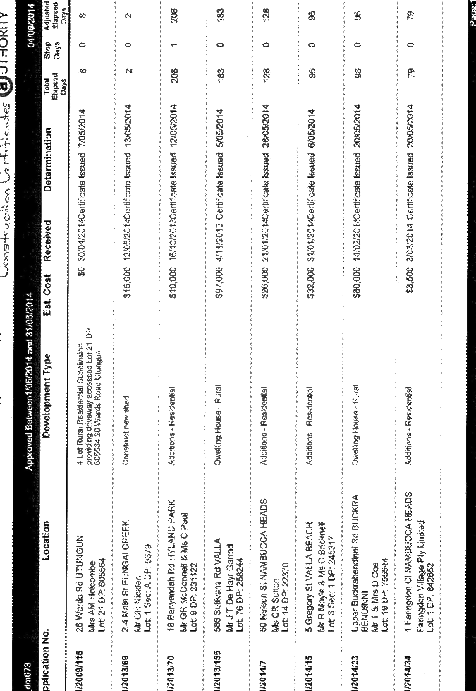
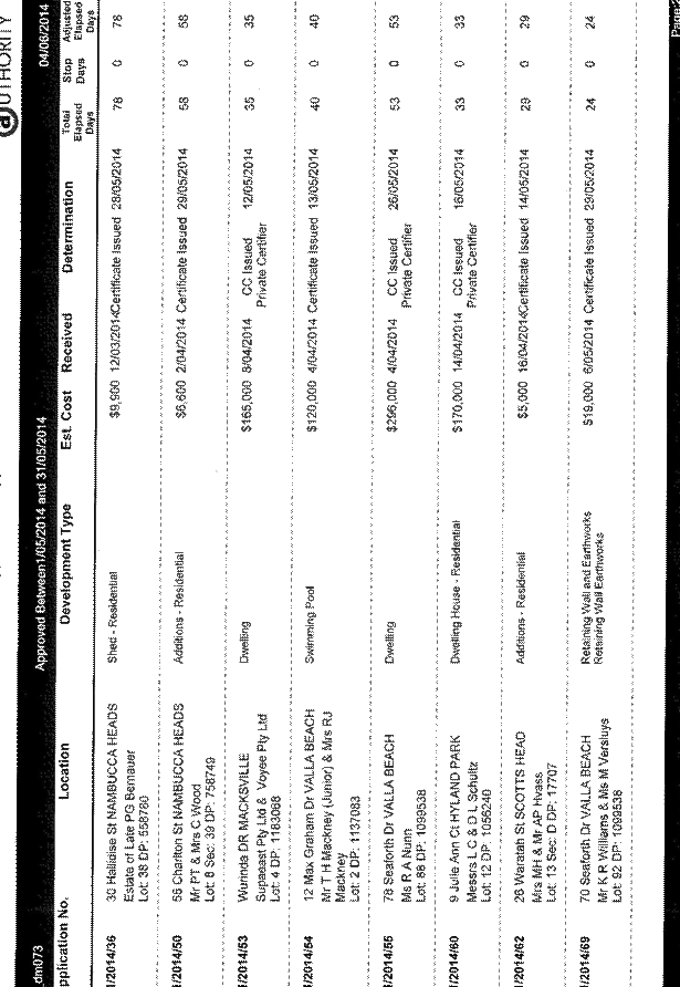

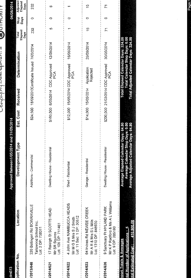
Ordinary Council Meeting 12
June 2014
General Manager's Report
ITEM 9.13 SF1947 120614 2014 May - Development and
Complying Development Applications Received
AUTHOR/ENQUIRIES: Lorraine Hemsworth, Executive Assistant
|
Summary:
Council at its
meeting 16 January 2014 resolved:
“That Council endorse the
method of reporting Construction and Complying Development Certificates as
presented to the 16 January 2014 meeting and further that the General Manager
investigate the possibility of reporting Development Applications lodged in
previous month.”
Below is a list of
Development Applications and Complying Development Applications received in
May 2014 as at 4 June 2014.
|
|
Recommendation:
That the
Development Applications and Complying Development Applications received in
May 2014 be received for information.
|
OPTIONS:
|
DA No
|
Date Received
|
Applicant/Owner
|
Proposal
|
Property
|
Amount
|
|
2014/68
|
02/5/14
|
Ritchie Kerr
|
5 Lot Residential
Subdivision
|
Lot 101 DP 1164163, 80 Upper
Warrell Creek Road Macksville
|
0
|
|
2014/069
|
06/5/14
|
K Williams, M Versluys &
G Cardow
|
Cut in house pad and
retaining wall construction
|
Lots 91 & 92 DP 1099538,
70 & 72 Seaforth Drive Valla Beach
|
19,000
|
|
2014/070
|
08/5/14
|
Shannon & Mitchell Tutt
|
New Dwelling and Rural Shed
|
Lot 8 DP1026500, Mitchells
Road Valla
|
380,000
|
|
2014/071
|
08/5/14
|
Spanline Coffs Harbour for S
Boucher & N Hopper
|
Deck
|
Lot 3 DP 264045, 3 Wattle
Close, Nambucca Heads
|
23,000
|
|
2014/072
|
08/5/14
|
Spanline Coffs Harbour for V
Craig
|
Screened Patio Cover
|
Lot 183 DP 259408, 30 Vista
Way, Scotts Head
|
25,000
|
|
2014/073
|
09/5/14
|
Mick Brooks Building Designs
for Ferrero & Chatenay
|
Dwelling & Swimming Pool
|
Lot 9 DP 1044587, 68 Ocean
View Drive, Valla Beach
|
280,000
|
|
2014/074
|
09/5/14
|
Mick Brooks Building Designs
for Gillpal & Knauer
|
Dwelling
|
Lot 10 DP 1059694, Glen
Sheather Drive, Nambucca Heads
|
200,000
|
|
2014/075
|
13/5/14
|
Terry Radnidge
|
Office / Security Block and
Retaining Wall
|
Lot 36 DP 731287, 8 Gumma
Close Macksville
|
73,000
|
|
2014/076
|
13/5/14
|
Adenbrook Homes / Heather
Gray
|
Single Level Dwelling,
garage, driveway and retaining wall
|
Lot 49 DP 1099538, 19
Seaforth Drive Valla Beach
|
332,778
|
|
2014/077
|
15/5/14
|
Stephanie Kay / Ivy Proctor
|
Existing Residence to Dual
Occupancy
|
Lot 19 DP 9654, 69 Sturdee
Street Macksville
|
30,000
|
|
2014/078
|
14/5/14
|
C Haddrick
|
Single Storey Dwelling and
Carport
|
Lot 168 DP 755537, Attards
Road Congarinni North
|
188,600
|
|
2014/079
|
14/5/14
|
Spanline Coffs Harbour / D J
& D M Morris
|
Addition - Patio Cover
|
Lot 15 DP 245783, 33 Nelson
Street Nambucca Heads
|
7,950
|
|
DA No
|
Date Received
|
Applicant/Owner
|
Proposal
|
Property
|
Amount
|
|
2014/80
|
20/5/14
|
Adam Styles & Michelle
Gruber
|
Home Business
|
Lot 21 DP 244537, 1 Buchanan
Street Valla Beach
|
|
|
2014/81
|
20/5/14
|
S W & J A Daw &
Quintessential Homes
|
Timber deck and stairs
|
Lot 3 DP 408073, 53 Palmer
Street Nambucca Heads
|
15,000
|
|
2014/82
|
20/5/14
|
S G & K M Osborne
|
3 Bay lock up shed
|
Lot 711 DP 630344, 116 Boat
Harbour Road Utungun
|
23,546
|
|
2014/83
|
20/5/14
|
North Coast Holiday Parks /
Nambucca Shire Council
|
Remove 63 sites and
establish 37 new sites
|
Lot 104 DP 622709, Adin
Street, Scotts Head
|
350,000
|
|
2014/84
|
21/5/14
|
Seren Building Services / C
J Ryan & R L Halloran
|
Construct split level
residence
|
Lot 2 DP1157698, 34 Short
Street Nambucca Heads
|
268,000
|
|
2014/85
|
21/5/14
|
Mick Brooks Building Designs
/ A M & A M Bulloch
|
Dwelling
|
Lot 10 DP 1048659, 14
Sandpiper Drive Scotts Head
|
250,000
|
|
2014/86
|
23/5/14
|
A R & S L Mills
|
Construct attached garage
|
Lot 1310 DP 848930, 64
Irvines Road Newee Creek
|
14,000
|
|
2014/87
|
26/5/14
|
Perry Homes / L Hyde & P
K M Nominees
|
Single storey dwelling
|
Lot 7 DP 1195236, 21 Rowe
Drive Macksville
|
178,000
|
|
2014/88
|
27/5/14
|
G R & J V Richter
|
Construct water storage dam
|
Lot 2 DP 869415, 10 Priory
Parade Valla
|
|
|
2014/89
|
29/5/14
|
Coral Homes C/- Professional
Certification / B & J Honeybrook
|
Two storey dwelling
|
Lot 81 DP 228703, 124 Ocean
View Drive Valla Beach
|
392,000
|
|
2014/90
|
29/5/14
|
Coral Homes C/- Professional
Certification / Sam Radoll
|
Single storey dwelling
|
Lot 711 DP 1190541, 61
Seaforth Drive Valla Beach
|
257,000
|
|
2014/91
|
20/5/14
|
Colin Haddrick / Crown
Reserve
|
Re Plank Crown Road timber
bridge
|
Attards Road North
Congarinni
|
5,000
|
|
2014/92
|
29/5/14
|
Paul Burgess
|
Single storey dwelling
|
Lot 42 DP 711098, Old Coast
Road North Macksville
|
160,000
|
|
CD No
|
Date Received
|
Applicant/
Owner
|
Private
Certifier
|
Proposal
|
Property
|
Amount
|
|
2014/621
|
13/5/14
|
Steve
Squires
|
Owner
Builder
|
Dwelling
|
Lot
106 DP 7111481, 17 Raleigh Street, Scotts Head
|
160,000
|
|
2014/622
|
15/5/14
|
M
G Smith
|
Private
Certifier - Brian Dwyer BPB0104
|
Shed
- Residential
|
Lot
11 Section 1 DP 30512, 4 John Avenue, Nambucca Heads
|
12,000
|
|
2014/623
|
15/5/14
|
A
R & S L Mills
|
|
Attached
Garage
|
Lot
1310 DP 848930, 64 Irvines Road Newee Creek
|
14,000
|
|
2014/624
|
28/5/14
|
Cavalier
Homes North Coast for Mitchell & McLeod
|
Cavalier
Homes North Coast
|
Dwelling
|
Lot
3 DP 1059694, 6 Coachwood Close, Nambucca Heads
|
203,963
|
|
2014/625
|
29/5/14
|
Mrs
M Fitzgerald
|
E
Coulter
|
Dwelling
Additions
|
Lot
2 DP 849631, 26 East Street, Macksville
|
48,000
|
Attachments:
There are no attachments for this report.
Ordinary Council Meeting 12
June 2014
Assistant
General Manager Corporate Services Report
ITEM 10.1 SF1875 120614 Investment Report To 31 May 2014
AUTHOR/ENQUIRIES: Faye Hawthorne, Accountant
|
Summary:
The return on investments from
1 July 2013 to 31 May 2014 is $1,354,202.28 (Cash Result)
Estimated Accrual interest up
to 30.6.14 is $583,036.63.
Anticipated interest return for
financial year is $1,937,238.91.
The budget allocation for the
financial year “2013/14” is $1,841,100.
Council currently has $39.34
Million invested:
· $5.8 Million with Managed Funds,
· $0.712 Million with On Call
Accounts
· $32.314 Million on Term Deposits,
· $0.514 Million in a Floating Rate
Note.
This report details all the
investments placed during April and Council funds invested as at 31 May 2014.
The following investment report
has been drawn up in accordance with the Local Government Act 1993 (as
amended), the Regulations and Council Policy 1.9 – Investment of Surplus
Funds
C P Doolan
Responsible Accounting
Officer
|
|
Recommendation:
That the
Accountants’ Report on Investments placed to 31 May 2014 be noted.
|


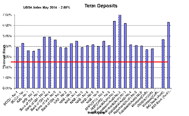

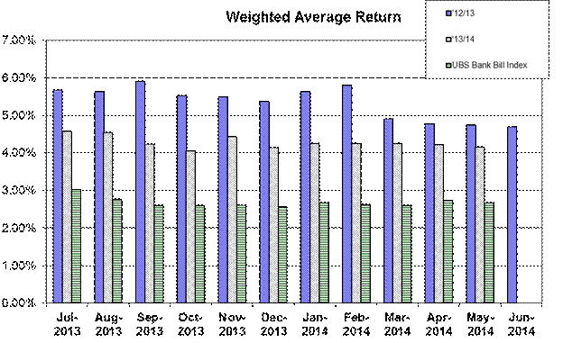
OPTIONS:
This report is for information
only.
DISCUSSION:
This report
details all the investments placed during May 2014 and Council funds invested
as at May 2014.
CONSULTATION:
Grove Research and Advisory
SUSTAINABILITY ASSESSMENT:
Environment
There are no environmental
implications.
Social
There are no
social implications.
Economic
Risk
That
Council may not meet its budget returns for 2013/2014 based on current
performance.
FINANCIAL
IMPLICATIONS:
Direct
and indirect impact on current and future budgets
A review of
budgeted interest returns for 2013/2014 has been completed with the March 2014
Budget Review and GPG Research & Advisory have provided Council with the
updated interest rates.
Source
of fund and any variance to working funds
Interest on
investments were assessed with the March 2014 Budget Review. Variances
have been distributed between the Water, Sewerage and General Funds for the
first half of the financial year.
Service
level changes and resourcing/staff implications
Not
applicable
Attachments:
There are no attachments for this report.
Ordinary Council Meeting 12
June 2014
Corporate Services
ITEM 10.2 SF251 120614 Schedule
of Council Public Meetings
AUTHOR/ENQUIRIES: Monika
Schuhmacher, Executive Assistant/Business Services Unit
|
SUMMARY:
The following is a schedule of
dates for public Council meetings. The meeting dates may change from to time
and this will be recorded in the next available report to Council.
|
|
Recommendation:
That the schedule of dates
for public Council meetings be noted and received for information by Council.
|
|
MEETING
|
DATE
|
VENUE
|
COMMENCING
|
|
Economic Directions C’tee
|
10/06/2014
|
Council Chambers
|
11.30
AM
|
|
Asset Management Workshop
|
12/06/2014
|
Council Chambers
|
4.00
PM
|
|
Ordinary Council Meeting
|
12/06/2014
|
Council Chambers
|
5.30
PM
|
|
Access Committee
|
24/06/2014
|
Council Chambers
|
2.00
PM
|
|
Ordinary Council Meeting
|
26/06/2014
|
Council Chambers
|
5.30
PM
|
|
Water Supply Steering
Committee
|
02/07/2014
|
Bowraville site
Leave Council Chambers at
10.15 am
|
10.45
AM
|
|
Ordinary Council Meeting
|
17/07/2014
|
Council Chambers
|
5.30
PM
|
|
Access Committee
|
22/07/2014
|
Council Chambers
|
2.00
PM
|
|
Ordinary Council Meeting
|
31/07/2014
|
Council Chambers
|
5.30
PM
|
|
Water Supply Steering
Committee
|
06/08/2014
|
Bowraville site
Leave Council Chambers at
10.15 am
|
10.45
AM
|
|
Ordinary Council Meeting
|
14/08/2014
|
Council Chambers
|
5.30
PM
|
|
Access Committee
|
26/08/2014
|
Council Chambers
|
2.00
PM
|
|
Ordinary Council Meeting
|
28/08/2014
|
Council Chambers
|
5.30
PM
|
|
Water Supply Steering
Committee
|
03/09/2014
|
Bowraville site
Leave Council Chambers at
10.15 am
|
10.45
AM
|
|
Economic Directions C’tee
|
09/06/2014
|
Council Chambers
|
11.30
AM
|
|
Ordinary Council Meeting
|
11/09/2014
|
Council Chambers
|
5.30
PM
|
|
Access Committee
|
23/09/2014
|
Council Chambers
|
2.00
PM
|
|
Ordinary Council Meeting
|
25/09/2014
|
Council Chambers
|
5.30
PM
|
|
Water Supply Steering
Committee
|
01/10/2014
|
Bowraville site
Leave Council Chambers at
10.15 am
|
10.45
AM
|
|
Ordinary Council Meeting
|
16/10/2014
|
Council Chambers
|
5.30
PM
|
|
Access Committee
|
28/10/2014
|
Council Chambers
|
2.00
PM
|
|
Ordinary Council Meeting
|
30/10/2014
|
Council Chambers
|
5.30
PM
|
|
Water Supply Steering
Committee
|
05/11/2014
|
Bowraville site
Leave Council Chambers at
10.15 am
|
10.45
AM
|
|
Ordinary Council Meeting
|
13/11/2014
|
Council Chambers
|
5.30
PM
|
|
Access Committee
|
25/11/2014
|
Council Chambers
|
2.00
PM
|
|
Ordinary Council Meeting
|
27/11/2014
|
Council Chambers
|
5.30
PM
|
|
Water Supply Steering
Committee
|
03/12/2014
|
Bowraville site
Leave Council Chambers at
10.15 am
|
10.45
AM
|
|
Ordinary Council Meeting
|
11/12/2014
|
Council Chambers
|
5.30
PM
|
Note:
Departure times to off-site meetings have been added.
Note:
Meetings at the Rural Halls commence with light refreshments at 5.00 pm.
Attachments:
There are no attachments for this report.
Ordinary Council Meeting 12
June 2014
Assistant
General Manager Engineering Services Report
ITEM 11.1 SF617 120614 Request for Council to upgrade the
end of Maras Creek Road to accommodate bus and truck movement
AUTHOR/ENQUIRIES: Clint Fitzsummons, Manager Assets
|
Summary:
On 23 March
2014 Council received a letter from Neville and Maureen Ward, 249 Maras Creek
Road requesting work on their dairy driveway which is frequently used as a
turnaround spot for the school bus and trucks.
|
|
Recommendation:
1 That Neville and Maureen Ward be advised that Council will
negotiate with the bus company regarding suitable turnaround locations and
that Council cannot level or extend the bitumen area on the dairy driveway as
this would be perceived as providing benefit to a private business.
2 Write to the bus company requesting information on bus routes, future
demand, and issues with buses turning around within the road reserve.
3 Incorporate bus route strategies within future Road Asset Management
Plans.
|
OPTIONS:
1 Receive
the report.
2 Construct
a turnaround area south of the dairy driveway at an approximate cost of
$20,000.
DISCUSSION:
The request
received from Neville and Maureen Ward was in two parts, but both related to
the use of their dairy driveway for a turnaround area for bus and trucks. The
first was a request to level the driveway to stop the bus from scraping while
performing the turning movement. The second was to seal the area to stop dust
in dry periods and mud during periods of wet weather. The dust in particular is
contaminating their milk supply.
As the
driveway is on private property it would not be advisable for Council to
provide any works that could be perceived as providing a benefit to a private
business. If Council was to do any work at all, it would have to be at a
location away from the dairy driveway. An estimate by Council’s Senior
Overseer indicated that construction of an area, to allow for a bus to
turnaround, would be in the order of $20,000. This could be located at the end
of the seal, approximately 20m south of the dairy driveway. It would however,
be difficult for Council to defend claims that the works did not provide
benefit to the dairy. This location is not at the end of the road, and it is
foreseeable that school children may need to be picked up by the school bus at
a point along the unsealed section of Maras Creek Road. This could then
require a new turnaround area to be constructed.
From time to
time Council receives requests for infrastructure in association with school
bus routes. Often these requests can be a substantial cost to Council, and are
only relevant for a short period of time. This is due to the school children
requiring the service, either growing up or moving on, which then makes the
service redundant at that location. Demographic changes mean that over time
different areas will require school bus services at different periods of time.
Precedence would then require similar services at the new locations that were
provided at the old locations. The problem being that any infrastructure
created, has a much longer life than the demand for the service.
CONSULTATION:
Manager Civil
Works
Senior
Overseer
SUSTAINABILITY
ASSESSMENT:
Environment
There may be
some environmental damage done, if a new turnaround area is constructed.
Social
There are no
social issues associated with this report.
Economic
There are no
social issues associated with this report.
Risk
There is a
risk that any works undertaken, could be perceived as benefiting a private
business.
FINANCIAL
IMPLICATIONS:
Direct
and indirect impact on current and future budgets
There is no
budget for this work. Funds would need to be sourced from existing budgeted
items. An increase in Asset area will impact on future renewal and maintenance
budgets.
Source
of fund and any variance to working funds
There is no
funding required with the recommendation. The construction of the turnaround
would require funding from the roads capital fund which would impact on the
existing programme.
Service
level changes and resourcing/staff implications
There are no
changes to service levels with the recommendation. The construction of a
turnaround area would be an increase in service level that may provide a
precedent for future requests.
Attachments:
There are no attachments for this report.
Ordinary Council Meeting 12
June 2014
Assistant General Manager
Engineering Services Report
ITEM 11.2 SF98 120614 Naming the Old Pacific Highway
AUTHOR/ENQUIRIES: Keith Williams, Manager Technical Services
|
Summary:
The Pacific
Highway within the Nambucca LGA is undergoing a number of by-pass projects
which involve detours of townships that exist on the highway alignment.
Currently 158 properties front the Pacific Highway in these localities and
they will all need new addresses.
The purpose of
this report is to consider a new road name for the existing highway that is
suitable as a property address and one that could be inviting for tourists
and revitalise / link the communities.
|
|
Recommendation:
That
Council contact and advise all property owners that have Pacific Highway
property frontage:
1 They will be required to change their
property address due to the Pacific Highway realignment when transfer of
ownership of the existing highway has been completed;
2 Council intends to adopt the road name
‘Nambucca Valley Way’ for the existing Pacific Highway alignment that will be
by-passed and that alternative names will be considered within the
advertising period and prior to final adoption;
3 The Datum Point or the point rural addressing
commences will be the intersection of Browns Crossing Road with numbering
proceeding in a northerly direction;
4 Road numbers will be allocated when
transfer of ownership of the existing highway has been completed.
|
OPTIONS:
1 Consult further with Bellingen Shire
Council for consideration of a suitable road name that extends through both
LGA’s
2 Advertise for submissions for a
suitable road name prior to advising Councils intention
3 Consider an alternative name
4 Seek advice from marketers for a name
that promotes the area
DISCUSSION:
The upgraded
highway through the Nambucca LGA will for the immediate term be known as
"Pacific Highway"
The 'old
Pacific Highway' will therefore need a new name, and with that new name will
come the requirement for addressing to change.
In terms of a
name it would be useful for the road to have the same name as the equivalent
sections in the Kempsey and Bellingen LGA’s, however Kempsey Shire have
recently named the Old Pacific Highway from South Kempsey to Eungai, Macleay
Valley Way which will eventually extent to Kundabung and link one side of the
shire to the other.
Bellingen
Shire may have already made decisions in relation to naming their section. At
its meeting of 31/5/2012 Council resolved as follows
That Council liaise with Bellingen Shire Council with suggestions to
rename the existing Pacific Highway that will be by-passed when the Warrell
Creek to Urunga Upgrade is complete, with examples being: Nambucca – Bellingen
Way or Twin Rivers Way.
Little
progress has been made, council staff had early discussions with consideration
given to naming the road ‘Twin Rivers Way’ extending across the Nambucca LGA,
through Urunga and connecting with Waterfall Way, this name however is not
suitable as there are more than two major rivers connected by the road.
Council will
need to select a new name before the upgrade is completed, so that all of the
signs are made with the new road name. This will be a good opportunity for the
community to consider a new road name that could be inviting for tourists and
link the communities.
An obvious
option for the road name is “Nambucca Valley Way”, however there may be more
imaginative suggestions such as ‘Giinagay Way’ as proposed by Council’s Manager
Community and Cultural Services, Giinagay is Hello in the local Gumbaynggirr
language. The Gumbaynggirr Nation stretches through both Bellingen and Nambucca
Shires.
Street
Numbers
Currently 158
properties front the Pacific Highway in the localities of Congarinni,
Donnellyville, Macksville, Nambucca Heads, North Macksville, Valla and Warrell
Creek with either Urban or Rural Road Numbers assigned, and will require new
addresses. (This excludes vacant rural properties that have not been assigned
a rural road number).
Based on the
Australian Standard for Urban and Rural Addressing, properties in the urban
areas of Mackville and North Mackville can retain their street numbers and
addresses of Cooper Street and Egan Street.
The urban
street numbering on the Pacific Highway at Nambucca Heads (Bellwood) begins at
Bellwood Creek/Riverside Drive and numbering proceeds in a southerly direction,
currently the Rural Road Numbers proceed in a northerly direction.
A decision on
the Datum Point or the point rural addressing commences is needed. Looking at
the document below, the intersection of Browns Crossing Road may be the Datum
Point with numbering proceeding in a northerly direction.
CONSULTATION:
General
Manager
Manager
Community Development
Senior GIS
Officer
Roads and
Maritime Services
Land &
Property Information Division - Department of Finance & Services
SUSTAINABILITY
ASSESSMENT:
Environment
No impact
Social
No impact
Economic
No perceived
impact
Risk
There is a
risk of missing out on an opportunity to adopt a road name that personifies the
attractions of the Valley and generates the interest of passing motorists.
FINANCIAL
IMPLICATIONS:
Direct
and indirect impact on current and future budgets
Costs
associated with advertising, measuring for road numbers and staff time
Source
of fund and any variance to working funds
Working
funds, or an application for RMS to cover costs
Service
level changes and resourcing/staff implications
A number of
days measuring and contacting affected residents and administration.
Attachments:
There are no attachments for this report.